Sainte-Lheurine
| Sainte-Lheurine | |
|---|---|
| Commune | |
 | |
 Sainte-Lheurine Location within Nouvelle-Aquitaine region  Sainte-Lheurine | |
| Coordinates: 45°31′52″N 0°21′54″W / 45.5312°N 0.365°WCoordinates: 45°31′52″N 0°21′54″W / 45.5312°N 0.365°W | |
| Country | France |
| Region | Nouvelle-Aquitaine |
| Department | Charente-Maritime |
| Arrondissement | Jonzac |
| Canton | Jonzac |
| Government | |
| • Mayor (2008–2014) | Jean-Pierre Mariau |
| Area1 | 17.78 km2 (6.86 sq mi) |
| Population (2016)2 | 519 |
| • Density | 29/km2 (76/sq mi) |
| Time zone | UTC+1 (CET) |
| • Summer (DST) | UTC+2 (CEST) |
| INSEE/Postal code | 17355 /17520 |
| Elevation |
36–109 m (118–358 ft) (avg. 106 m or 348 ft) |
|
1 French Land Register data, which excludes lakes, ponds, glaciers > 1 km2 (0.386 sq mi or 247 acres) and river estuaries. 2 Population without double counting: residents of multiple communes (e.g., students and military personnel) only counted once. | |
Sainte-Lheurine is a commune in the Charente-Maritime department in the Nouvelle-Aquitaine region in southwestern France.
Location and economy
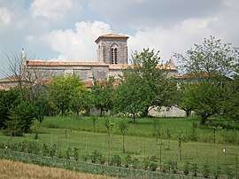
The village centre with its church from the 12th century is situated on a small hill that overlooks the vineyards, patches of forest, and the wheat, maize and sunflower fields that characterize the local landscape. A number of scattered small hamlets and single farmsteads in the plains below belong to the commune.
Sainte-Lheurine lies in the "Petite Champagne", and the cultivation of grapes for the production of Cognac and Pineau is the predominant local economic activity, with much of the production sold to the large cognac producers in nearby Cognac.
Population
| Historical population | ||
|---|---|---|
| Year | Pop. | ±% |
| 1962 | 529 | — |
| 1968 | 549 | +3.8% |
| 1975 | 510 | −7.1% |
| 1982 | 473 | −7.3% |
| 1990 | 476 | +0.6% |
| 1999 | 455 | −4.4% |
| 2008 | 461 | +1.3% |
| 2016 | 519 | +12.6% |
See also
References
External links
| Wikimedia Commons has media related to Sainte-Lheurine. |