Taillebourg, Charente-Maritime
| Taillebourg | ||
|---|---|---|
| Commune | ||
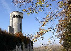 Chateau | ||
| ||
 Taillebourg Location within Nouvelle-Aquitaine region  Taillebourg | ||
| Coordinates: 45°50′15″N 0°38′32″W / 45.8375°N 0.6422°WCoordinates: 45°50′15″N 0°38′32″W / 45.8375°N 0.6422°W | ||
| Country | France | |
| Region | Nouvelle-Aquitaine | |
| Department | Charente-Maritime | |
| Arrondissement | Saint-Jean-d'Angély | |
| Canton | Saint-Jean-d'Angély | |
| Intercommunality | Pays Savinois | |
| Government | ||
| • Mayor (2008–2014) | Guy Perret | |
| Area1 | 14.25 km2 (5.50 sq mi) | |
| Population (2008)2 | 732 | |
| • Density | 51/km2 (130/sq mi) | |
| Time zone | UTC+1 (CET) | |
| • Summer (DST) | UTC+2 (CEST) | |
| INSEE/Postal code | 17436 /17350 | |
| Elevation | 2–63 m (6.6–206.7 ft) | |
|
1 French Land Register data, which excludes lakes, ponds, glaciers > 1 km2 (0.386 sq mi or 247 acres) and river estuaries. 2 Population without double counting: residents of multiple communes (e.g., students and military personnel) only counted once. | ||

Taillebourg is a commune in the Charente-Maritime department in southwestern France.
It is built on a rock, overlooking the Charente River, 9 km downstream from Saintes.
It was the site of three battles that bear its name: Battle of Taillebourg, on account of its strategically important position as a river crossing. There was also a fourth action, a siege.
The château dominates the town and was the garrison of Louis IX (known as 'Saint Louis'), before the eponymous 1242 battle.
The ancient bridge over the Charente has since been destroyed but there is a long causeway, which spans the surrounding marshes and serves to keep the road open, even during times of flooding.
Population
| Historical population | ||
|---|---|---|
| Year | Pop. | ±% |
| 1962 | 636 | — |
| 1968 | 681 | +7.1% |
| 1975 | 637 | −6.5% |
| 1982 | 626 | −1.7% |
| 1990 | 561 | −10.4% |
| 1999 | 600 | +7.0% |
| 2008 | 732 | +22.0% |
See also
References
External links
| Wikimedia Commons has media related to Taillebourg (Charente-Maritime). |