Saint-Nazaire-sur-Charente
| Saint-Nazaire-sur-Charente | |
|---|---|
| Commune | |
 | |
 Saint-Nazaire-sur-Charente Location within Nouvelle-Aquitaine region  Saint-Nazaire-sur-Charente | |
| Coordinates: 45°56′12″N 1°03′06″W / 45.9367°N 1.0517°WCoordinates: 45°56′12″N 1°03′06″W / 45.9367°N 1.0517°W | |
| Country | France |
| Region | Nouvelle-Aquitaine |
| Department | Charente-Maritime |
| Arrondissement | Rochefort |
| Canton | Tonnay-Charente |
| Intercommunality | Sud-Charente |
| Government | |
| • Mayor (2008–2014) | Christiane Le Roux |
| Area1 | 20.31 km2 (7.84 sq mi) |
| Population (2008)2 | 1,102 |
| • Density | 54/km2 (140/sq mi) |
| Time zone | UTC+1 (CET) |
| • Summer (DST) | UTC+2 (CEST) |
| INSEE/Postal code | 17375 /17780 |
| Elevation |
0–21 m (0–69 ft) (avg. 12 m or 39 ft) |
|
1 French Land Register data, which excludes lakes, ponds, glaciers > 1 km2 (0.386 sq mi or 247 acres) and river estuaries. 2 Population without double counting: residents of multiple communes (e.g., students and military personnel) only counted once. | |
Saint-Nazaire-sur-Charente is a commune in the Charente-Maritime department in southwestern France.
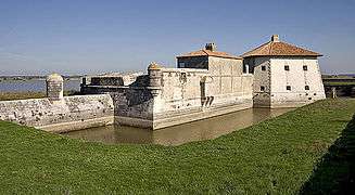
In the 1680s, Fort Lupin was constructed near Saint-Nazaire-sur-Charente.[1]
Population
| Historical population | ||
|---|---|---|
| Year | Pop. | ±% |
| 1962 | 743 | — |
| 1968 | 770 | +3.6% |
| 1975 | 664 | −13.8% |
| 1982 | 855 | +28.8% |
| 1990 | 834 | −2.5% |
| 1999 | 850 | +1.9% |
| 2008 | 1,102 | +29.6% |
See also
References
- ↑ "Monuments historiques". culture.gouv.fr (in French). Retrieved 8 September 2015.
| Wikimedia Commons has media related to Saint-Nazaire-sur-Charente. |
This article is issued from
Wikipedia.
The text is licensed under Creative Commons - Attribution - Sharealike.
Additional terms may apply for the media files.