Rosslyn station
Rosslyn | |||||||||||||||||||||
|---|---|---|---|---|---|---|---|---|---|---|---|---|---|---|---|---|---|---|---|---|---|
|
| |||||||||||||||||||||
 | |||||||||||||||||||||
| Location |
1850 North Moore Street Arlington, VA 22209 | ||||||||||||||||||||
| Owned by | WMATA | ||||||||||||||||||||
| Line(s) |
| ||||||||||||||||||||
| Platforms | 2 split platforms (1 on each level) | ||||||||||||||||||||
| Tracks | 2 (1 on each level) | ||||||||||||||||||||
| Connections |
| ||||||||||||||||||||
| Construction | |||||||||||||||||||||
| Structure type | Underground | ||||||||||||||||||||
| Depth |
175 feet (53 m) Upper Level 195 feet (59 m) Lower Level | ||||||||||||||||||||
| Platform levels | 2 | ||||||||||||||||||||
| Bicycle facilities | 20 racks | ||||||||||||||||||||
| Disabled access | Yes | ||||||||||||||||||||
| Other information | |||||||||||||||||||||
| Station code | C05 | ||||||||||||||||||||
| History | |||||||||||||||||||||
| Opened | July 1, 1977 | ||||||||||||||||||||
| Traffic | |||||||||||||||||||||
| Passengers (2017) |
12,436 daily[1] | ||||||||||||||||||||
| Services | |||||||||||||||||||||
| |||||||||||||||||||||
Rosslyn /ˈrɒzlɪn/ is the westernmost station on the shared segment of the Blue, Orange, and Silver lines of the Washington Metro. It is located in the Rosslyn neighborhood of Arlington, Virginia, United States. Rosslyn is the first station in Virginia heading westward from the District on the Orange and Silver Lines and southward on the Blue Lines. It is one of four interchange points on the Metrorail system west of the Potomac River and located in a growing business district.
Depending on the year, Rosslyn is the busiest, or one of the busiest stations outside the District of Columbia, along with Pentagon City and Pentagon, which are also in Arlington. Rosslyn is the biggest choke point of the Metro system. Due to this, planners are considering adding another station in the Rosslyn neighborhood, possibly as part of an inner loop through Washington and Arlington.[2]
Location
The station has entrances on the west side of North Moore Street between Wilson Boulevard and 19th Street North and on the east side of Fort Myer Drive between Wilson Boulevard and 19th Street North. A bank of three high-speed street elevators to the mezzanine (upper) level of the station is on the east side of North Moore Street, across the street from the station entrance. The station is a stop for several express Metrobus lines, including the 5A to Washington Dulles International Airport and L'Enfant Plaza.
History
The station opened on July 1, 1977.[3] Its opening coincided with the completion of 11.8 miles (19.0 km)[4] of rail between National Airport and RFK Stadium and the opening of the Arlington Cemetery, Capitol South, Crystal City, Eastern Market, Farragut West, Federal Center SW, Federal Triangle, Foggy Bottom–GWU, L'Enfant Plaza, McPherson Square, National Airport, Pentagon, Pentagon City, Potomac Avenue, Smithsonian and Stadium–Armory stations.[5] Orange Line service to the station began upon the line's opening on November 20, 1978.[6]
Station layout
Rosslyn is one of two stations (the other being the Pentagon station on the Blue and Yellow Lines) at which westbound trains serve a platform that is a level below the mezzanine-level platform for eastbound trains. This allows for trains to converge inbound and diverge outbound via a flying junction to avoid an at-grade crossing.[7]
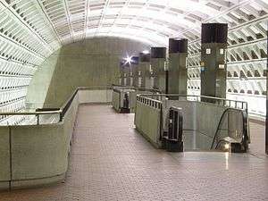
Since the neighborhood is on a bluff over the Potomac River and the shared rail line into Washington passes through a rock-bored tunnel, Rosslyn is deep: the deepest on the three lines servicing it. It is the second deepest station in the system, behind only Medical Center. The upper platform is 175 feet below street level; the lower platform is another 20 feet below that. An escalator ride between the street and mezzanine levels takes about three minutes.[8] It is one of three stations on the Metro with platform-level fare gates and elevators. A new bank of three high-speed elevators and an expanded mezzanine opened officially on October 7, 2013.[9] It replaces the original single street elevator, cutting elevator transit time from about a minute to about 17 seconds. The underground hallway to the new elevator bank contains a four-coffered arch like most underground stops on the Red Line that were opened after 1980. This is the only stop on the Blue, Orange, and Silver Lines with this arch. It is also the only stop in the system that contains both the waffle and four-coffer arch design.
| G | Street level | Exit/entrance |
| B2 | Eastbound | |
| Side platform, doors will open on the left | ||
| Mezzanine | One-way faregates, ticket machines, station agent | |
| B3 | Side platform, doors will open on the left | |
| Westbound | ← ← ← | |
Notable places nearby
Gallery
| Wikimedia Commons has media related to Rosslyn station. |
.jpg)

References
- ↑ "Metrorail Average Weekday Passenger Boardings" (PDF). Washington Metropolitan Area Transit Authority. May 2017. Retrieved February 17, 2018.
- ↑ "Metro considers building 'inner loop' of new stations to ease congestion in system's core". The Washington Post.
- ↑ Feaver, Douglas B. (July 1, 1977), "Today, Metro could be U.S. model", The Washington Post, p. A1
- ↑ "Sequence of Metrorail openings" (PDF). WMATA. 2017. p. 3. Retrieved April 25, 2018.
- ↑ Staff Reporters (June 24, 1977), "Metro's newest stations: Where they are, what's nearby", The Washington Post
- ↑ Eisen, Jack; John Feinstein (November 18, 1978), "City-County fanfare opens Orange Line; Ceremonies open new Orange Line", The Washington Post, p. D1
- ↑ "Rosslyn Station New Entrance Study" (PDF). WMATA. March 2007. Retrieved April 3, 2009.
- ↑ Rosslyn Magazine: Discover A New Horizon, Vol. 1, Issue 2, Summer 2006, p. 21.
- ↑ Arlington County news release 10/7/2013
- ↑ Johnson, Matt. "What are the Ten Longest Metro Escalators?". Greater Greater Washington, July 8, 2014. http://greatergreaterwashington.org/post/23038/what-are-the-10-longest-metro-escalators
External links
- WMATA: Rosslyn Station
- StationMasters Online: Rosslyn Station
- The Schumin Web Transit Center: Rosslyn Station
- Fort Myer Drive entrance from Google Maps Street View
- Moore Street entrance from Google Maps Street View
Coordinates: 38°53′46″N 77°04′19″W / 38.896031°N 77.071846°W