Mitcham, London
| Mitcham | |
|---|---|
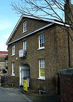
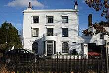
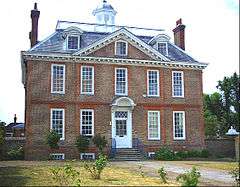 Eagle House, London Road, Mitcham, built in 1705 | |
 Mitcham Mitcham shown within Greater London | |
| Population | 63,393 (103,298 the Mitcham and Morden parliamentary seat)[1] |
| OS grid reference | TQ285685 |
| London borough | |
| Ceremonial county | Greater London |
| Region | |
| Country | England |
| Sovereign state | United Kingdom |
| Post town | MITCHAM |
| Postcode district | CR4 |
| Dialling code | 020 |
| Police | Metropolitan |
| Fire | London |
| Ambulance | London |
| EU Parliament | London |
| UK Parliament | |
| London Assembly | |
Mitcham is a district in south west London, located within the London Borough of Merton. It is centred 7.2 miles (11.6 km) south-west of Charing Cross. A suburban area, Mitcham is located on the border of Inner London and Outer London, and is in the historic county of Surrey. It is both residentially and financially developed and served by train, bus and tram routes. Localities within Mitcham include Mitcham Town Centre and Mitcham Common. Amenities include Mitcham Library and Mitcham Cricket Green. Nearby districts include Wimbledon, Streatham, Croydon, Tooting, Morden and Sutton. Mitcham itself had a population of 63,393 which includes the electoral wards of Cricket Green, Figges Marsh, Graveney, Lavender Fields, Longthornton and Pollards Hill in 2011[2] but its urban area had a population of 103,298.
Location
Mitcham is in the east of the London Borough of Merton and is bounded by the London Borough of Wandsworth, the London Borough of Croydon, the London Borough of Lambeth and the London Borough of Sutton. Mitcham is close to Wimbledon, Croydon, Streatham and Tooting. The River Wandle bounds the town to the southwest. The original village lies in the west, although expansion has pushed the eastern boundary the furthest. Mitcham Common takes up the greater part of the boundary and area to the south.
History
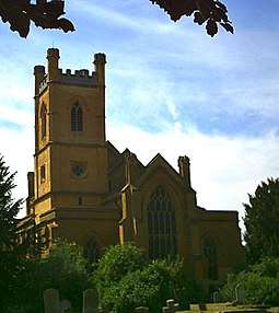
The toponym "Mitcham" is Old English in origin and means big settlement. Before the Romans and Saxons were present, there was a Celtic settlement in the area, with evidence of a hill fort in the Pollards Hill area. The discovery of Roman-era graves and a well on the site of the Mitcham gas works evince Roman settlement. The Saxon graveyard, located on the North bank of the Wandle is the largest discovered to date, and many of the finds therein are on display in the British Museum. Scholars such as Myres have suggested that Mitcham and other Thames Valley settlements were some of the first populated by the Anglo-Saxons. The area is a possible location for the Battle of Merton, 871, in which King Ethelred of Wessex was either mortally wounded or killed outright. The Church of England parish church of St Peter and St Paul dates from the Saxon era. Although it was mostly rebuilt in 1819–21, the current building retains the original Saxon tower. The Domesday Book of 1086 lists Mitcham as a small farming community, with 250 people living in two hamlets; Mitcham, an area known today as Upper Mitcham; and Whitford, today known as the Lower Green area.
The area lay within the Anglo-Saxon administrative division of Wallington hundred.
The Domesday Book records Mitcham as Michelham. It was held partly by the Canons of Bayeux; partly by William, son of Ansculf and partly by Osbert.[3] Its domesday assets were: 8 hides and 1 virgate. It had ½ mill worth £1, 3½ ploughs, 56 acres (23 ha) of meadow. It rendered £4 5s 4d.
During her reign Queen Elizabeth I made at least five visits to the area. John Donne and Sir Walter Raleigh also had residences here in this era. It was at this time that Mitcham became gentrified, as due to the abundance of lavender fields Mitcham became renowned for its soothing air. The air also led people to settle in the area during times of plague.
When industrialisation occurred, Mitcham quickly grew to become a town and most of the farms were swallowed up in the expansion. Remnants of this farming history today include: Mitcham Common itself; Arthur's Pond, sited on the corner of Watney's Road and Commonside East, and named for a local farmer; Alfred Mizen School (Now named Garden Primary), named after a local nursery man who was very charitable towards the burgeoning town; and the road New Barnes Avenue, which was named after the farm that stood on that site.
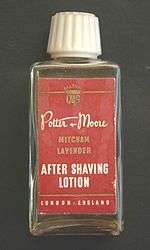
There were many lavender fields in Mitcham, and peppermint and lavender oils were also distilled. In 1749 two local physic gardeners, John Potter and William Moore, founded a company to make and market toiletries made from locally-grown herbs and flowers.[4] Lavender features on Merton Council's coat of arms and the badge of the local football team, Tooting & Mitcham United F.C., as well as in the name of a local council ward, Lavender Field.
Mitcham was industrialised first along the banks of the Wandle, where snuff, copper, flour, iron and dye were all worked. Mitcham, along with nearby Merton Abbey, became the calico cloth printing centres of England by 1750. Asprey, suppliers of luxury goods made from various materials, was founded in Mitcham as a silk-printing business in 1781. William Morris opened a factory on the River Wandle at Merton Abbey. Merton Abbey Mills were the Liberty silk-printing works. It is now a craft village and its waterwheel has been preserved.
The activity along the Wandle led to the building of the Surrey Iron Railway, the World's first public railway, in 1803. The decline and failure of the railway in the 1840s also heralded a change in industry, as horticulture gradually gave way to manufacturing, with paint, varnish, linoleum and firework manufacturers moving into the area. The work provided and migratory patterns eventually resulted in a doubling of the population between the years 1900 and 1910.
Mitcham became a borough on 19 September 1934 with the charter of incorporation being presented to the 84-year-old mayor, Mr. R.M. Chart, by the Lord Lieutenant of Surrey, Lord Ashcombe.[5]
| 19th Century | 20th Century | ||
|---|---|---|---|
| 1801 | 3,466 | 1901 | 14,903 |
| 1811 | 4,175 | 1911 | 29,606 |
| 1821 | 4,453 | 1921 | 35,119 |
| 1831 | 4,387 | 1931 | 56,859 |
| 1841 | 4,532 | 1941¹ | war |
| 1851 | 4,641 | 1951 | 67,269 |
| 1861 | 5,078 | 1961 | 63,690 |
| 1871 | 6,498 | 1971 | 60,608 |
| 1881 | 8,960 | 1981 | 57,158 |
| 1891 | 12,127 | 1991² | n/a |
| |||
| source: UK census | |||
Social housing schemes in the 1930s included New Close, aimed at housing people made homeless by a factory explosion in 1933 and Sunshine Way, for housing the poor from inner London. This industry made Mitcham a target for German bombing during World War II. During this time Mitcham also returned to its agricultural roots, with Mitcham Common being farmed to help with the war effort.
From 1929 the electronics company Mullard had a factory on New Road.
Post war, the areas of Eastfields, Phipps Bridge and Pollards Hill were rebuilt to provide cheaper more affordable housing. The largest council housing project in Mitcham is Phipps Bridge estate. Further expansion of the housing estates in Eastfields, Phipps Bridge and Pollards Hill occurred after 1965. In Mitcham Cricket Green, the area lays reasonable, although not definitive, claim to having the world's oldest cricket ground in continual use, and the world's oldest club in Mitcham Cricket Club.[6] The ground is also notable for having a road separate the pavilion from the pitch.[6] The club believes it is underthreat from development as its landlord has, in August 2018, put in a housing planning permission application. [6] Local folklore also claims Mitcham has the oldest fair in England, believing it to have been granted a charter by Queen Elizabeth I, although this claim has not been proven.
- Literature
Mitcham is referred to in a rhyme dating back to the 18th century. The rhyme was revised in the Victorian era as:
| “ | Sutton for good mutton; Cheam for juicy beef; |
” |
Open Space
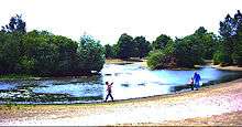
Mitcham is home to a large area (460 acres) of South London's open green space in the form of Mitcham Common. There are several ponds and buildings on the Common.
The Seven Islands pond is the largest of all the ponds, and was created as the result of gravel extraction conducted in the 19th century.[8] The most recent, Bidder's pond, was created in 1990 and named after George Parker Bidder.
Notable buildings
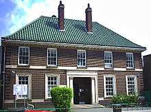
- The Canons. House originally built in 1680; it was the home of the family Cranmer until it was sold to the local council in 1939. The name originates from an Augustinian priory that was given this site in the 12th Century. The pond next to which it is located and the dovecote both predate the house.[9]
- Eagle House, built in 1705. Eagle House is a Queen Anne house built in the Dutch style on land formerly owned by Sir Walter Raleigh. It is on London Road, Mitcham, the grounds forming a triangle bounded by London Road, Bond Road and Western Road. The building was commissioned by the marrano doctor Fernando Mendes (1647–1724), former physician to King Charles II.
- Mitcham Common Windmill, a post mill dating from 1806.
- Old Mitcham Station, on the Surrey Iron Railway route. Now called Station Court, the building was a former merchant's home and is possibly the oldest station in the world.
- The Tate Almshouses, built in 1829 to provide for the poor by Mary Tate.
- The Watermead Fishing Cottages.
- Vestry Hall, the annex of which now houses the Wandle Industrial Museum.
- Mitcham Public Library, built in 1933.
- Elm Lodge, 1808. This listed Regency house was occupied by Dr. Parrott, a village doctor, in the early 19th century, and for a short time by the artist, Sir William Nicholson. The curved canopy over the entrance door is a typical feature of this period.
- Mitcham Court. The centre portion, first known as Elm Court, was built in 1840, the wings later. Caesar Czarnikow, a sugar merchant, lived here circa 1865–86 and presented the village with a new horse-drawn fire engine. Sir Harry Mallaby-Deeley, M.P., conveyed the house to the borough in the mid-1930s. The Ionic columned porch and the ironwork on the ground floor windows are notable features.
- Renshaw's factory, a marzipan factory, founded in 1898 in the City and thus one of the earliest in the country, which came to Mitcham in 1924. It was on Locks Lane until 1991, when the company moved its operations to Liverpool. The factory was featured in three 1950s British Pathe News shorts. The building has lent its name to the area where it stood, Renshaw Corner.
- Poulters Park, Home to Mitcham Rugby Union Football Club
- Imperial Fields, Tooting & Mitcham United F.C.'s home ground.
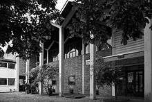
- Mitcham Methodist Church was designed by the architect Edward Mills (1915–1998), and built in 1958-9. Regarded as the best surviving work by the most successful Nonconformist architect of the period. A radical and inspiring building that was forwarded by the 20th Century Society for listing as it was under threat. Grade II listed on 5 March 2010.[10]
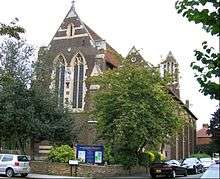
- St Barnabas church, Gorringe Park Avenue, Mitcham. Built in the gothic style, on 17 May 1913 the foundation stone of the church building was laid, and on 14 November 1914 the church was consecrated - by the bishop of Southwark. The architect was HP Burke-Downing. The building is still in use as an Anglican church. Both the church itself and the adjacent parish hall are Grade II listed.
- The White House, Mitcham on which the wall plaque says: "This 18th Century house was renovated in the Regency style in 1826 by Dr.A.C.Bartley, a village doctor, whose daughter wrote reminiscences of old Mitcham. The house remained in his family until 1919. Fluted Greek Doric columns support a slightly altered porch with a bowed front." Grade II listed.
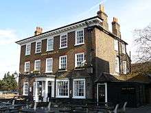
- The Burn Bullock Public House, London Road, Mitcham is a three-storey Grade II listed building originally called the King's Head Hotel. The front of the building dates from the 18th century whilst its wing dates from the 16th and 17th centuries.[11] It is named after a well known, former cricket player from the locality.[12][6]
Notable residents
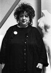
- Jo Brand – comedian
- Steve Brookstein – winner of The X Factor
- Roy Budd – jazz musician
- John Donne – Jacobean poet
- M.I.A. – singer, songwriter and rapper
- Master Shortie – MC
- Michael Fielding – The Mighty Boosh comedian
- Noel Fielding – The Mighty Boosh comedian
- Mike Fillery – footballer
- David Gibson – cricketer
- Florence Harmer - historian
- Neil Howlett – opera singer
- Maxwell Knight – spymaster
- Chris Powell – manager of League One football club Southend United and former footballer
- Annie Ross – jazz singer
- Shane Smeltz – New Zealand footballer
- Alex Stepney – former Manchester United footballer and 1968 European Cup winner
- Herbert Strudwick – cricket wicket-keeper
- John Mosely Turner – supercentenarian
- Slick Rick - East coast Rapper who was born in Surrey then moved to the U.S at the age of 11
- William Allison White – recipient of the Victoria Cross
- Faryadi Sarwar Zardad – Afghan warlord; later tried for war crimes, convicted and imprisoned
- Jill Gascoine – actress - married to actor Alfred Molina and starred in The Gentle Touch. Lived in Caithness Road, Mitcham
Demography
- Mitcham and Morden (Westminster Parliamentary Constituency)
- Population - 103,298[1]
- Ethnic Group[13]
British - 40,608, Irish - 1,840, Gypsy or Irish Traveller - 161, Other White - 12,899
White and Black Caribbean - 1,862, White and Black African - 856, White and Asian - 1,163, Other Mixed - 1,444
Indian - 4,536, Pakistani - 5,054, Bangladeshi - 1,484, Chinese - 1,169, Other Asian - 10,194
- Black/African/Caribbean
African - 9,036, Caribbean - 7,029, Other Black - 1,912
- Other Ethnic Group
Arab - 670, Other ethnic group - 1,381
- Religion[14]
Buddhist - 862, Sikh - 252, Jewish - 147, Other Religion - 362
- Gender[15]
- Female: 52,237
- Male: 51,061
Transport and locale
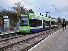
Mitcham is served by two train stations, Mitcham Junction and Mitcham Eastfields. Mitcham Eastfields is the first suburban station to be built in 50 years in the area. Both stations are served by Southern and Thameslink with direct trains to London Victoria, London Bridge (peaks only), Blackfriars, City Thameslink, St Pancras railway station for the Central London stations, as well as direct links by train to St Albans, Bedford and Luton airport north of London and Epsom, Horsham and Dorking south of London. Trains on the Thameslink route from Central London continue on the loop via Sutton and Wimbledon back towards Central London. London Tramlink also serves Mitcham with 4 stops in the area; Mitcham Junction, Mitcham, Belgrave Walk & Phipps Bridge. Trams provide a direct service to Wimbledon, Croydon and New Addinton from Mitcham and also Beckenham Junction and Elmers End with a change at Croydon.
Bus
Bus services operated by London Buses are available from Mitcham. These include night buses to Aldwych and Liverpool Street in central London.
Coach
National Express services 024 London Victoria to Eastbourne, 025 London Victoria to Brighton and Worthing via Gatwick Airport, 026 London Victoria to Bognor Regis and A3 London Victoria to Gatwick Airport hourly shuttle all stop at Mitcham (Downe Road/Mitcham Library bus stop)
Neighbouring areas | |
|---|---|
Footnotes
- "Merry Making at Mitcham". Wayback Machine. The University of Sheffield's National Fairground Archive. Archived from the original on 21 December 2004.
- "Making Merton". Merton Council. Archived from the original on 26 April 2009.
- "A Brief History of Merton by John Precedo: Part 1 - Romans to the Norman Conquest". Wayback Machine. Tooting Community Website. Archived from the original on 13 April 2005.
- Eric Norman Montague (1976). The 'Canons' Mitcham. Merton Historical Society. ISBN 0-9501488-3-0.
- Eric Norman Montague (2001). North Mitcham. Merton Historical Society. ISBN 1-903899-07-9.
- Eric Norman Montague (1996). The Historic River Wandle: Phipps Bridge to Morden Hall. Merton Historical Society. ISBN 0-905174-25-9.
References
- 1 2 "Population Density, 2011". Area: Mitcham and Morden (Westminster Parliamentary Constituency). Office for National Statistics.
- ↑ "Archived copy". Archived from the original on 22 February 2014. Retrieved 2014-06-09.
- ↑ "Surrey". The Domesday Book online - Surrey.
- ↑ "Potter and Moore - An Introduction". Potter & Moore.
- ↑ Daily Mirror page 13, 19 September 1934
- 1 2 3 4 Siddique, Haroon (19 August 2018). "World's oldest village cricket green under threat from developers, club says". the Guardian. Retrieved 19 August 2018.
- ↑ "Chapter XIV: Local Allusions to Women". sacred-texts.com. Retrieved 5 December 2013.
- ↑ wandlevalleypark.co.uk
- ↑ "The Canons, Mitcham: Dovecote - Merton Memories Photographic Archive". photoarchive.merton.gov.uk. Retrieved 2016-01-26.
- ↑ "Mitcham Methodist Church, exterior (E. Mills)". Flickr.
- ↑ "British Listed Buildings: Burn Bullock Public House, Merton". britishlistedbuildings.co.uk.
- ↑ "Burn Bullock, Mitcham, Surrey". ukpubfinder.com.
- ↑ "Ethnic Group, 2011". Area: Mitcham and Morden (Westminster Parliamentary Constituency). Office for National Statistics.
- ↑ "Religion, 2011". Area: Mitcham and Morden (Westminster Parliamentary Constituency). Office for National Statistics.
- ↑ "Se, 2011". Area: Mitcham and Morden (Westminster Parliamentary Constituency). Office for National Statistics.
External links
| Districts | 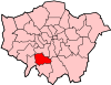 | |
|---|---|---|
| Attractions | ||
| Parks and open spaces | ||
| Constituencies | ||
| Tube, rail stations and tram stops | ||
| Other topics | ||