List of districts in the London Borough of Havering
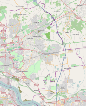
Neighbourhoods: metropolitan centres (blue) and district centres (green)
This is a list of the districts of the London Borough of Havering in London, England.
Neighbourhoods
All these areas became part of the borough when it was created on 1 April 1965. It is indicated where a district formed an earlier independent unit of local administration. As the planning authorities, Havering London Borough Council classify seven locations as town centres. The Greater London Authority identifies Romford to be a metropolitan centre and the remaining town centres as district centres.
Wards and area committees
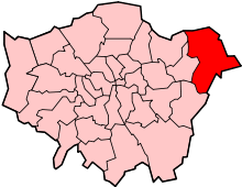
Havering within Greater London
Within London, population figures are not collected for localities, instead they are enumerated for political wards.
| Ward | Area committee | Population (2011)[1] | Parliamentary constituency |
|---|---|---|---|
| Brooklands | Romford | 14,957 | Romford |
| Cranham | Upminster | 12,528 | Hornchurch and Upminster |
| Elm Park | Elm Park and Hylands | 12,466 | Dagenham and Rainham |
| Emerson Park | Emerson Park and Harold Wood | 11,977 | Hornchurch and Upminster |
| Gooshays | Harold Hill | 14,692 | Hornchurch and Upminster |
| Hacton | Hornchurch | 12,262 | Hornchurch and Upminster |
| Harold Wood | Emerson Park and Harold Wood | 12,650 | Hornchurch and Upminster |
| Havering Park | North Romford | 13,000 | Romford |
| Heaton | Harold Hill | 12,570 | Hornchurch and Upminster |
| Hylands | Elm Park and Hylands | 12,952 | Romford |
| Mawneys | North Romford | 12,915 | Romford |
| Pettits | Gidea Park | 12,955 | Romford |
| Rainham and Wennington | South Hornchurch and Rainham | 12,482 | Dagenham and Rainham |
| Romford Town | Romford | 15,921 | Romford |
| St Andrew's | Hornchurch | 13,334 | Hornchurch and Upminster |
| South Hornchurch | South Hornchurch and Rainham | 13,544 | Dagenham and Rainham |
| Squirrel's Heath | Gidea Park | 13,194 | Romford |
| Upminster | Upminster | 12,833 | Hornchurch and Upminster |
References
- Footnotes
- ↑ Census Information Scheme (2012). "2011 Census Ward Population Estimates". Greater London Authority. Retrieved 30 January 2013.
- Bibliography
- Mills, D. (2000). Oxford Dictionary of London Place Names. Oxford.
- Royal Mail (2004). Address Management Guide (4 ed.). Royal Mail Group.
| Districts |
| |
|---|---|---|
| Attractions | ||
| Major retail | ||
| Places of worship | ||
| Parks and open spaces | ||
| Constituencies | ||
| Tube and rail stations | ||
| Other topics | ||
This article is issued from
Wikipedia.
The text is licensed under Creative Commons - Attribution - Sharealike.
Additional terms may apply for the media files.