Seven Kings
| Seven Kings | |
|---|---|
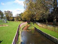 Seven Kings - Westwood Recreation Ground | |
 Seven Kings Seven Kings shown within Greater London | |
| Population | 15,164 (2011 Census.Ward)[1] |
| OS grid reference | TQ455875 |
| London borough | |
| Ceremonial county | Greater London |
| Region | |
| Country | England |
| Sovereign state | United Kingdom |
| Post town | ILFORD |
| Postcode district | IG3 |
| Dialling code | 020 |
| Police | Metropolitan |
| Fire | London |
| Ambulance | London |
| EU Parliament | London |
| UK Parliament | |
| London Assembly | |
Seven Kings is a district of Ilford in east London, England. It is part of the London Borough of Redbridge and forms part of the Ilford post town.
Seven Kings Park is a large open space containing sports facilities such as tennis courts,a sports ground, and a bandstand; there is also Westwood Park, a smaller open space and playground in Meads Lane. It also borders the districts of Ilford and Goodmayes.
History
The earliest recorded use of the name is as Sevekyngg or Sevekyngges in 1285, meaning 'settlement of the family or followers of a man called Seofoca'.[2]
Seven Kings has not historically formed a parish or other division; instead it was part of the ancient parish of Ilford in the Becontree hundred of the county of Essex,[3] which formed from 1894 the Ilford Urban District (later municipal borough).[4] Seven Kings is situated next to the ancient Roman road between London and Colchester and was rapidly developed during the 19th century following construction of the Great Eastern Main Line railway.
In 1965 the Ilford parish and municipal borough were abolished by the London Government Act 1963, and the area of Essex including Seven Kings has since formed part of Greater London.[4]
Education
Located in the immediate area are Mayfield High School (London), Palmer Catholic Academy and Seven Kings High School. Primary schools in this area include Downshall Primary School, Farnham Green Primary School, South Park Primary School, Seven Kings Primary School and Eastcourt Independent School.
Transport
The area is served by Seven Kings railway station on the Great Eastern Main Line to/from Liverpool Street station. Train services are operated by TfL Rail, branded as Crossrail since May 2017.
The nearest London Underground station is Newbury Park on the Central line.
References
- ↑ "Redbridge Ward population 2011". Neighbourhood Statistics. Office for National Statistics. Retrieved 18 October 2016.
- ↑ Mills, A., Oxford Dictionary of London Place Names, (2001)
- ↑ Vision of Britain - Ilford parish (historic map Archived 1 October 2007 at the Wayback Machine.)
- 1 2 Vision of Britain Archived 1 October 2007 at the Wayback Machine. - Ilford UD/MB
External links
![]()
| Districts | 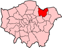 | |
|---|---|---|
| Attractions |
| |
| Constituencies | ||
| Parks and open spaces |
| |
| Tube and rail stations | ||
| History | ||
| Other topics | ||