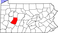
Robinson, Indiana County, Pennsylvania
| Robinson, Pennsylvania | |
|---|---|
| Census-designated place | |
 Robinson  Robinson | |
| Coordinates: 40°24′18″N 79°08′18″W / 40.40500°N 79.13833°WCoordinates: 40°24′18″N 79°08′18″W / 40.40500°N 79.13833°W | |
| Country | United States |
| State | Pennsylvania |
| County | Indiana |
| Township | West Wheatfield |
| Area | |
| • Total | 0.99 sq mi (2.56 km2) |
| • Land | 0.98 sq mi (2.55 km2) |
| • Water | 0.004 sq mi (0.01 km2) |
| Elevation | 1,119 ft (341 m) |
| Population (2010) | |
| • Total | 614 |
| • Density | 620/sq mi (240/km2) |
| Time zone | UTC-5 (Eastern (EST)) |
| • Summer (DST) | UTC-4 (EDT) |
| ZIP code | 15949 |
| FIPS code | 42-65360 |
| GNIS feature ID | 2630035 |
Robinson is a census-designated place[1] located in West Wheatfield Township, Indiana County in the state of Pennsylvania. The community is located near the Westmoreland County line and the borough of Bolivar, along Pennsylvania Route 259. As of the 2010 census the population was 614 residents.[2]
References
- ↑ https://www.census.gov/2010census/
- ↑ "American FactFinder". United States Census Bureau. Retrieved 2011-05-14.
External links
This article is issued from
Wikipedia.
The text is licensed under Creative Commons - Attribution - Sharealike.
Additional terms may apply for the media files.
