Dilltown, Pennsylvania
| Dilltown, Pennsylvania | |
|---|---|
| Unincorporated community | |
 Dilltown  Dilltown | |
| Coordinates: 40°27′59″N 79°00′09″W / 40.46639°N 79.00250°WCoordinates: 40°27′59″N 79°00′09″W / 40.46639°N 79.00250°W | |
| Country | United States |
| State | Pennsylvania |
| County | Indiana |
| Township | East Wheatfield |
| Elevation | 1,345 ft (410 m) |
| Time zone | UTC-5 (Eastern (EST)) |
| • Summer (DST) | UTC-4 (EDT) |
| ZIP code | 15929 |
| Area code(s) | 814 |
| GNIS feature ID | 1173725[1] |
Dilltown is an unincorporated community in Indiana County, Pennsylvania, United States.[1] The community is located along Blacklick Creek and Pennsylvania Route 403 13.3 miles (21.4 km) southeast of Indiana. Dilltown has a post office with ZIP code 15929.[2][3]
References
- 1 2 "Dilltown". Geographic Names Information System. United States Geological Survey.
- ↑ United States Postal Service. "USPS - Look Up a ZIP Code". Retrieved December 19, 2015.
- ↑ "Postmaster Finder - Post Offices by ZIP Code". United States Postal Service. Retrieved December 19, 2015.
Municipalities and communities of Indiana County, Pennsylvania, United States | ||
|---|---|---|
| Boroughs | 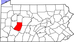 | |
| Townships | ||
| CDPs | ||
| Unincorporated communities | ||
This article is issued from
Wikipedia.
The text is licensed under Creative Commons - Attribution - Sharealike.
Additional terms may apply for the media files.