Coral, Pennsylvania
| Coral, Pennsylvania | |
|---|---|
| Census-designated place | |
 Coral  Coral | |
| Coordinates: 40°30′08″N 79°10′28″W / 40.50222°N 79.17444°WCoordinates: 40°30′08″N 79°10′28″W / 40.50222°N 79.17444°W | |
| Country | United States |
| State | Pennsylvania |
| County | Indiana |
| Township | Center |
| Area | |
| • Total | 0.18 sq mi (0.47 km2) |
| • Land | 0.18 sq mi (0.46 km2) |
| • Water | 0.004 sq mi (0.01 km2) |
| Elevation | 1,066 ft (325 m) |
| Population (2010) | |
| • Total | 325 |
| • Density | 1,800/sq mi (690/km2) |
| Time zone | UTC-5 (Eastern (EST)) |
| • Summer (DST) | UTC-4 (EDT) |
| ZIP code | 15731 |
| FIPS code | 42-16136 |
| GNIS feature ID | 2634210 |
Coral is a census-designated place[1] located in Center Township, Indiana County, Pennsylvania, United States. The community is located between the borough of Homer City and the community of Black Lick on U.S. Route 119. It is bordered to the north by Graceton. As of the 2010 census the population of Coral was 325.[2]
References
- ↑ "Archived copy". Archived from the original on 2013-12-21. Retrieved 2015-12-29.
- ↑ "American FactFinder". United States Census Bureau. Archived from the original on 2013-09-11. Retrieved 2011-05-14.
External links
Municipalities and communities of Indiana County, Pennsylvania, United States | ||
|---|---|---|
| Boroughs | 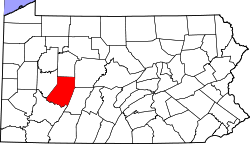 | |
| Townships | ||
| CDPs | ||
| Unincorporated communities | ||
| Counties |  Map of the Pittsburgh Tri-State with green counties in the metropolitan area and yellow counties in the combined area. | |
|---|---|---|
| Major cities | ||
| Cities and towns 15k-50k (in 2010) | ||
| Airports | ||
| Topics | ||
| ||
This article is issued from
Wikipedia.
The text is licensed under Creative Commons - Attribution - Sharealike.
Additional terms may apply for the media files.