Alverda, Pennsylvania
| Alverda, Pennsylvania | |
|---|---|
| Unincorporated community | |
 Alverda  Alverda | |
| Coordinates: 40°37′49″N 78°51′25″W / 40.63028°N 78.85694°WCoordinates: 40°37′49″N 78°51′25″W / 40.63028°N 78.85694°W | |
| Country | United States |
| State | Pennsylvania |
| County | Indiana |
| Township | Pine |
| Elevation | 1,913 ft (583 m) |
| Time zone | UTC-5 (Eastern (EST)) |
| • Summer (DST) | UTC-4 (EDT) |
| ZIP code | 15710 |
| Area code(s) | 814 |
| GNIS feature ID | 1168240[1] |
Alverda is an unincorporated community in Indiana County, Pennsylvania, United States.[1] The community is located on Pennsylvania Route 553 15.5 miles (24.9 km) east of Indiana. Alverda has a post office with ZIP code 15710.[2][3]
References
- 1 2 "Alverda". Geographic Names Information System. United States Geological Survey.
- ↑ United States Postal Service. "USPS - Look Up a ZIP Code". Retrieved December 19, 2015.
- ↑ "Postmaster Finder - Post Offices by ZIP Code". United States Postal Service. Retrieved December 19, 2015.
Municipalities and communities of Indiana County, Pennsylvania, United States | ||
|---|---|---|
| Boroughs | 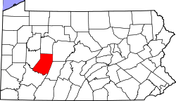 | |
| Townships | ||
| CDPs | ||
| Unincorporated communities | ||
This article is issued from
Wikipedia.
The text is licensed under Creative Commons - Attribution - Sharealike.
Additional terms may apply for the media files.