East Mahoning Township, Indiana County, Pennsylvania
| East Mahoning Township, Pennsylvania | |
|---|---|
| Township | |
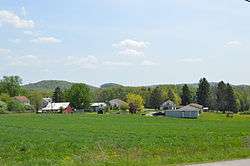
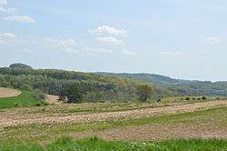 Fields along Pennsylvania Route 210 | |
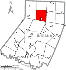 Map of Indiana County, Pennsylvania Highlighting East Mahoning Township | |
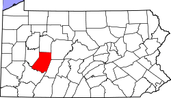 Map of Pennsylvania highlighting Indiana County | |
| Country | United States |
| State | Pennsylvania |
| County | Indiana |
| Area[1] | |
| • Total | 31.37 sq mi (81.25 km2) |
| • Land | 31.28 sq mi (81.01 km2) |
| • Water | 0.09 sq mi (0.24 km2) |
| Population (2010) | |
| • Total | 1,077 |
| • Estimate (2016)[2] | 1,024 |
| • Density | 32.74/sq mi (12.64/km2) |
| Time zone | UTC-5 (Eastern (EST)) |
| • Summer (DST) | UTC-4 (EDT) |
| FIPS code | 42-063-21456 |
East Mahoning Township is a township in Indiana County, Pennsylvania, in the United States. As of the 2010 census, the township population was 1,077,[3] down from 1,196 at the 2000 census. East Mahoning Township was created when Mahoning Township was divided into four parts (East, West, North, and South) in 1846. It contains the communities of Georgeville, Hamill, Mottarns Mill, and Savan.[4] It surrounds but does not include the borough of Marion Center.
Geography
According to the United States Census Bureau, the township has a total area of 31.4 square miles (81 km2), all of it land.
Demographics
| Historical population | |||
|---|---|---|---|
| Census | Pop. | %± | |
| 2010 | 1,077 | — | |
| Est. 2016 | 1,024 | [2] | −4.9% |
| U.S. Decennial Census[5] | |||
As of the census[6] of 2000, there were 1,196 people, 423 households, and 326 families residing in the township. The population density was 38.1 people per square mile (14.7/km2). There were 473 housing units at an average density of 15.1/sq mi (5.8/km2). The racial makeup of the township was 98.24% White, 0.33% African American, 1.00% Asian, 0.25% from other races, and 0.17% from two or more races.
There were 423 households, out of which 39.0% had children under the age of 18 living with them, 63.4% were married couples living together, 9.7% had a female householder with no husband present, and 22.7% were non-families. 20.3% of all households were made up of individuals, and 9.0% had someone living alone who was 65 years of age or older. The average household size was 2.83 and the average family size was 3.28.
In the township the population was spread out, with 29.2% under the age of 18, 10.0% from 18 to 24, 28.0% from 25 to 44, 21.9% from 45 to 64, and 10.9% who were 65 years of age or older. The median age was 35 years. For every 100 females there were 92.3 males. For every 100 females age 18 and over, there were 91.2 males.
The median income for a household in the township was $28,700, and the median income for a family was $33,523. Males had a median income of $28,906 versus $20,795 for females. The per capita income for the township was $13,168. About 16.5% of families and 19.3% of the population were below the poverty line, including 26.8% of those under age 18 and 4.7% of those age 65 or over.
References
- ↑ "2016 U.S. Gazetteer Files". United States Census Bureau. Retrieved Aug 14, 2017.
- 1 2 "Population and Housing Unit Estimates". Retrieved June 9, 2017.
- ↑ "Geographic Identifiers: 2010 Census Summary File 1 (G001): East Mahoning township, Indiana County, Pennsylvania". American Factfinder. U.S. Census Bureau. Retrieved April 11, 2018.
- ↑ http://www.rootsweb.ancestry.com/~paicgs/townships/eastmahoning.shtml
- ↑ "Census of Population and Housing". Census.gov. Retrieved June 4, 2016.
- ↑ "American FactFinder". United States Census Bureau. Archived from the original on 2013-09-11. Retrieved 2008-01-31.
Coordinates: 40°47′00″N 78°59′59″W / 40.78333°N 78.99972°W
Municipalities and communities of Indiana County, Pennsylvania, United States | ||
|---|---|---|
| Boroughs | | |
| Townships | ||
| CDPs | ||
| Unincorporated communities | ||
| Counties |  Map of the Pittsburgh Tri-State with green counties in the metropolitan area and yellow counties in the combined area. | |
|---|---|---|
| Major cities | ||
| Cities and towns 15k-50k (in 2010) | ||
| Airports | ||
| Topics | ||
| ||