Redlands, California
| Redlands, California | ||
|---|---|---|
| City | ||
| ||
| Nickname(s): "Jewel of the Inland Empire"[1] | ||
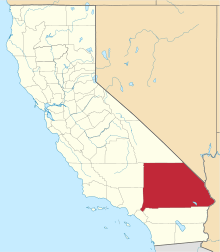
 Location of Redlands in California | ||
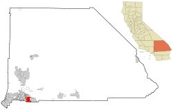
 Redlands Location in the United States  Redlands Redlands (the US) | ||
| Coordinates: 34°3′17″N 117°10′57″W / 34.05472°N 117.18250°WCoordinates: 34°3′17″N 117°10′57″W / 34.05472°N 117.18250°W | ||
| Country |
| |
| State |
| |
| County | San Bernardino | |
| Incorporated | December 3, 1888[2] | |
| Government | ||
| • Type | Council-Manager[3] | |
| • Mayor | Paul Foster[3] | |
| Area[4] | ||
| • Total | 36.33 sq mi (94.10 km2) | |
| • Land | 36.03 sq mi (93.32 km2) | |
| • Water | 0.30 sq mi (0.78 km2) 0.83% | |
| Elevation[5] | 1,358 ft (414 m) | |
| Population (2010)[6] | ||
| • Total | 68,747 | |
| • Estimate (2016)[7] | 71,288 | |
| • Density | 1,900/sq mi (730/km2) | |
| Time zone | UTC-8 (Pacific) | |
| • Summer (DST) | UTC-7 (PDT) | |
| ZIP codes[8] | 92373–92374 | |
| Area code | 909[9] | |
| FIPS code | 06-59962 | |
| GNIS feature IDs | 0252966, 2411532 | |
| Website |
www | |
Redlands /ˈrɛdlɪndz/ (Serrano: Tukut) is a city in San Bernardino County, California, United States. It is a part of the Greater Los Angeles area. As of the 2010 census, the city had a population of 68,747,[6] up from 63,591 at the 2000 census. The population was estimated at 69,999 in 2013.[6] The city is located approximately 10 miles (16 km) east of downtown San Bernardino.
History
The area now occupied by Redlands was originally part of the territory of the Morongo and Aguas Calientes tribes of Cahuilla people. Explorations such as those of Pedro Fages and Francisco Garcés sought to extend Catholic influence to the indigenous people and the dominion of the Spanish crown into the area in the 1770s. The Serrano (Mountain-Dwellers) village of Guachama, located just to the west of present-day Redlands, was visited by Fr. Francisco Dumetz in 1810, and was the reason the site was chosen for a mission outpost. Dumetz reached the village on May 20, the feast day of Saint Bernardino of Siena, and thus named the region the San Bernardino Valley.[10] The Franciscan friars from Mission San Gabriel established the San Bernardino Asistencia in 1819 and embarked on the usual program of training the native tribes to raise crops and encouraging permanent settlements. By 1820, a ditch, known as a zanja, was dug by the natives for the friars from Mill Creek to the Asistencia. In 1822, word of the Mexican triumph in the War of Independence reached the inland area, and lands previously claimed by Spain passed to the custody of the Mexican government.
In 1842, the Lugo family bought the Rancho San Bernardino Mexican land grant and this became the first fixed settler civilization in the area. The area northwest of current Redlands, astride the Santa Ana River, would become known as Lugonia. In 1851, the area received its first Anglo inhabitants in the form of several hundred Mormon pioneers, who purchased the entire Rancho San Bernardino, founded nearby San Bernardino, and established a prosperous farming community watered by the many lakes and streams of the San Bernardino Mountains. The Mormon community left wholesale in 1857, recalled to Utah by Brigham Young during the tensions with the federal government that ultimately led to the brief Utah War. Benjamin Barton purchased 1,000 acres (4 km2) from the Latter-day Saints and planted extensive vineyards and built a winery.[11]
"The first settler on the site of the present Redlands is recorded to have erected a hut at the corner of what is now Cajon St. and Cypress Ave.; he was a sheep herder, and the year, 1865," reported Ira L. Swett in "Tractions of the Orange Empire." Lugonia attracted settlers; in 1869, Barry Roberts, followed a year later by the Craw and Glover families. "The first school teacher in Lugonia, George W. Beattie, arrived in 1874—shortly followed by the town's first negro settler, Israel Beal."[12]
Railroads
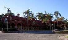
In the 1880s, the arrival of the Southern Pacific and Atchison, Topeka and Santa Fe Railroads, connecting Southern California to San Francisco and Salt Lake triggered a land boom, with speculators such as John W. North flooding the area now known as the Inland Empire. North and others saw the area, with its hot, dry climate and ready access to water as an ideal center for citrus production. The city of Redlands was soon established by Frank E. Brown, a civil engineer, and E. G. Judson, a New York stock broker, to provide a center (along with North's nearby settlement at Riverside) for the burgeoning citrus industry. They named their city “Redlands” after the color of the adobe soil.[13] So large had the area grown by 1888 that it was decided to incorporate. "A red-letter day in the Annals of Redlands," pronounced Scipio Craig, editor of The Citrograph newspaper, of the November 26 incorporation.[14][15] The original community of Lugonia was absorbed at this time. The newspaper was first published in July 1887 by The Citrograph Printing Company, which remains in 2017 as both Redlands' oldest business and the longest-operating printing company in California.[16]
The Redlands Street Railway Company was incorporated on March 22, 1888, acquiring on June 5 a franchise from the San Bernardino County Supervisors dating to December 1887, conveying the right to construct, operate and maintain for a term of 50 years a line of street railways in Redlands, Terracina and vicinity.[17] The initial operations began in June 1889 with a single-track line operating two-mule-team cars, the first street railway company of several to provide service to the community. Electrification and new rails replaced mules in 1899,[18] with electrical operation beginning in December.[19] Most Redlands street railways would pass to the San Bernardino Valley Traction Company in a consolidation on June 3, 1903,[20] and thence to the Pacific Electric in the "Great Merger" of Huntington properties under new ownership by the Southern Pacific Transportation Company on February 8, 1911.[21] Henry E. Huntington, nephew of late Southern Pacific president Collis P. Huntington, had gained control of the four-mile (6 km)-long streetcar line of the Redlands Central Railway Company in 1908.[22]
The Pacific Electric Railway completed an interurban connection between Los Angeles and San Bernardino in 1914, providing a convenient, speedy connection to the fast-growing city of Los Angeles and its new port at San Pedro, bringing greater prosperity to the town and a new role as a vacation destination for wealthy Angelenos. Redlands was the eastern terminus of the "Big Red Car" system. At its peak, PE operated five local routes in Redlands, with streetcars running to Smiley Heights, and on Orange, Olive, and Citrus Avenues.[23] Pacific Electric interurban service to Redlands was abandoned on July 20, 1936, with 2.07 miles (3.33 km) of track into the city lifted,[24] although PE and Southern Pacific (parent company of PE) provided freight service as far as the Sunkist packing plant at Redlands Heights on San Bernardino Avenue[25] into at least the 1970s. The Smiley Heights line was abandoned at this time, as well. Bus service operated by the Motor Transit Company, a subsidiary of Pacific Electric, began on July 20.[26] This also affected mail delivery in Redlands as "Approximately 80 percent of our mail from all directions arrives on the 5 a.m. electric car," explained Postmaster James B. Stone. "This dispatch is sorted and morning deliveries started by 8:30 a.m. on most routes. The post office department has temporarily arranged for this mail to be brought in by the Santa Fe train at 6:05 a.m. As this arrival is an hour later, our service will be one hour later."[27] The abandoned Pacific Electric La Quinta trestle over the Santa Ana River stands today, immediately south of San Bernardino International Airport.
Electricity
"History was made in the electrical industry July 27, 1892, when a franchise was granted to the Electric Light & Power Co., which was incorporated Oct. 6 and began building a powerhouse in Mill Creek canyon. Thus the groundwork was laid for the world's first (three)-phase transmission line, which brought electricity to Redlands and later became a unit in the Southern California Edison Co."[28] The 250 kilowatt AC Mill Creek No. 1 Hydroelectric Plant was designed by Almirian Decker.[29] Electric arc lamps were first illuminated over Redlands streets on August 5, 1893. George B. Ellis, one of seven men who spearheaded the undertaking, is largely credited with originating the plan.[19]
"The first line was extended from the Mill Creek powerhouse to East Citrus avenue, thence to Redlands and to Mr. Ellis' Terracina hotel. By September the company was advertising power for sale to the public. The firm boasted of ability to supply current enough for 55 arc lamps, and 1,500 homes."[28] Engineer O. H. Ensign was "largely responsible for the success of the undertaking." When gas lighting became available in Redlands in 1900, many homes already had electricity.[19]
"The same group of men in 1894 organized the Southern California Power Co. Later it was merged with the Edison Electric Co., of Los Angeles, a forerunner of the Southern California Edison Co."[19]
Citrus
In the spring of 1882, Mr. E. J. Waite of Wisconsin planted the first orange grove in the city. For almost 75 years, the city was the center of the largest navel orange producing region in the world.[30] By the late 1930s, Redlands was a fruit-packing center surrounded by more than 15,000 acres (61 km2) of citrus groves. The city produced more than 4,200 railcars of navel oranges and 1,300 cars of Valencia oranges during the 1937–38 growing season.[31] During the 1930s and 1940s, labor activists campaigned in the canneries and packing houses for union representation and higher wages. The United Cannery, Agricultural, Packing, and Allied Workers of America (UCAPAWA) won 13 National Labor Relations Board representation elections in the Riverside-Redlands area in 1943. In 1945, the first annual Orange Queen Ball at the Redlands City Auditorium was held to raise funds for the union.[32]
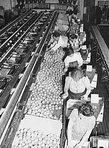
The citrus industry declined in the area as more agricultural areas were replaced by subdivisions, and all three citrus packing houses (two in downtown and one on San Bernardino Avenue) had closed by the end of the 1900s. Today only one packing house remains to serve the needs of approximately the 2,500 acres (10 km2) of citrus that remains in production in the area.
Community
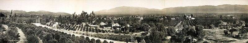
At the turn of the 20th century, Redlands was the "Palm Springs" of the next century, with roses being planted along many city thoroughfares. Some of these plantings would survive as wild thickets into the 1970s, especially adjacent to orange groves where property management was lax. Washingtonia palms (Washingtonia robusta) were planted along many main avenues. In fact, Redlands was the first city to have center medians with trees or gardens in between roads. So beautifully kept was the area, with the dramatic mountain backdrops, that for several years the Santa Fe Railroad operated excursion trains along the loop that passed through the orange groves of Redlands and Mentone, across the Santa Ana River, and back into San Bernardino via East Highlands, Highlands and Patton, and advertised as the "Kite Route" due to its multi-sided alignment. The trestle over "the Wash" north of Mentone was carried away during a flood in March 1938 and never replaced, the line being truncated there. The Southern Pacific branch line from the San Timoteo Canyon to Crafton was abandoned after the downtown packing house business died. A thru-truss bridge over the Zanja (locally pronounced "san-kee") exists today, abandoned in place. Burlington Northern Santa Fe, result of the AT&SF-Burlington Northern merger, applied to abandon its San Bernardino-connected branch line east of downtown Redlands in 2007, the last shippers at Crafton and Mentone having ceased operations. A move was made by transit activists to have this branch revitalized as part of the Southern California transit districts, but it came to nothing.
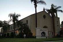
The city has been visited by three U.S. Presidents: William McKinley was the first in 1901, followed by Theodore Roosevelt in 1903 and William Howard Taft in 1909. Local landmarks include the A.K. Smiley Public Library, a Moorish-style library built in 1898, and the Redlands Bowl, built in 1930 and home of the oldest continuously free outdoor concert series in the United States. Located behind the Smiley Library is the Lincoln Shrine,[33] the only memorial honoring the "Great Emancipator", the sixteenth president, west of the Mississippi River. Famous homes include “America’s Favorite Victorian,” the Morey Mansion,[34] on Terracina Boulevard, and the Kimberly Crest House and Gardens, a home museum featured on the PBS series “America’s Castles.” Named after the family that purchased the house, the owners of Kimberly-Clark (makers of paper goods and Kleenex), it is a beautiful mansion set high on a hill overlooking the whole valley. Redlands is still regarded as the "Jewel of the Inland Empire."[35]
In the mid-late 20th Century, Redlands was home to various light manufacturing firms, and became a bedroom community for the military personnel and contractor employees of the aerospace industry that supported missions at Norton Air Force Base, as well as the Lockheed Propulsion Company plant in Mentone.
Geography
According to the United States Census Bureau, the city has a total area of 36.4 square miles (94 km2). 36.1 square miles (93 km2) of it is land and 0.3 square miles (0.78 km2) of it (0.83%) is water.
Climate
The climate in this area is described by the Köppen Climate Classification System as "dry-summer subtropical" often referred to as "Mediterranean" and abbreviated as Csa.[36]
Demographics
| Historical population | |||
|---|---|---|---|
| Census | Pop. | %± | |
| 1890 | 1,904 | — | |
| 1900 | 4,797 | 151.9% | |
| 1910 | 10,449 | 117.8% | |
| 1920 | 9,571 | −8.4% | |
| 1930 | 14,177 | 48.1% | |
| 1940 | 14,324 | 1.0% | |
| 1950 | 18,429 | 28.7% | |
| 1960 | 26,829 | 45.6% | |
| 1970 | 36,355 | 35.5% | |
| 1980 | 43,619 | 20.0% | |
| 1990 | 60,394 | 38.5% | |
| 2000 | 63,591 | 5.3% | |
| 2010 | 68,747 | 8.1% | |
| Est. 2016 | 71,288 | [7] | 3.7% |
| U.S. Decennial Census[37] | |||
2010
The 2010 United States Census[38] reported that Redlands had a population of 68,747. The population density was 1,887.3 people per square mile (728.7/km²). The racial makeup of Redlands was 47,452 (69.0%) White (54.0% Non-Hispanic White),[6] 3,564 (5.2%) African American, 625 (0.9%) Native American, 5,216 (7.6%) Asian, 235 (0.3%) Pacific Islander, 8,266 (12.0%) from other races, and 3,389 (4.9%) from two or more races. Hispanic or Latino of any race were 20,810 persons (30.3%).
The Census reported that 66,379 people (96.6% of the population) lived in households, 1,856 (2.7%) lived in non-institutionalized group quarters, and 512 (0.7%) were institutionalized.
There were 24,764 households, out of which 8,598 (34.7%) had children under the age of 18 living in them, 12,374 (50.0%) were opposite-sex married couples living together, 3,397 (13.7%) had a female householder with no husband present, 1,291 (5.2%) had a male householder with no wife present. There were 1,255 (5.1%) unmarried opposite-sex partnerships, and 164 (0.7%) same-sex married couples or partnerships. 6,083 households (24.6%) were made up of individuals and 2,198 (8.9%) had someone living alone who was 65 years of age or older. The average household size was 2.68. There were 17,062 families (68.9% of all households); the average family size was 3.21.
The population was spread out with 16,273 people (23.7%) under the age of 18, 8,185 people (11.9%) aged 18 to 24, 17,381 people (25.3%) aged 25 to 44, 17,930 people (26.1%) aged 45 to 64, and 8,978 people (13.1%) who were 65 years of age or older. The median age was 36.2 years. For every 100 females, there were 90.9 males. For every 100 females age 18 and over, there were 87.3 males.
There were 26,634 housing units at an average density of 731.2 per square mile (282.3/km²), of which 15,061 (60.8%) were owner-occupied, and 9,703 (39.2%) were occupied by renters. The homeowner vacancy rate was 2.2%; the rental vacancy rate was 7.9%. 41,102 people (59.8% of the population) lived in owner-occupied housing units and 25,277 people (36.8%) lived in rental housing units.
During 2009–2013, Redlands had a median household income of $66,835, with 12.5% of the population living below the federal poverty line.[6]
2000
As of the census[39] of 2000, there were 63,591 people, 23,593 households, and 16,019 families residing in the city. The population density was 1,793.1 inhabitants per square mile (692.2/km²). There were 24,790 housing units at an average density of 699.0 per square mile (269.8/km²). The racial makeup of the city was 73.7% White, 4.3% African American, 0.9% Native American, 5.1% Asian, 0.2% Pacific Islander, 11.3% from other races, and 4.4% from two or more races. Hispanic or Latino of any race were 24.1% of the population.
There were 23,593 households out of which 33.5% had children under the age of 18 living with them, 50.6% were married couples living together, 13.0% had a female householder with no husband present, and 32.1% were non-families. 26.0% of all households were made up of individuals and 9.2% had someone living alone who was 65 years of age or older. The average household size was 2.6 and the average family size was 3.2.
In the city, the population was spread out with 26.2% under the age of 18, 10.7% from 18 to 24, 27.9% from 25 to 44, 22.7% from 45 to 64, and 12.6% who were 65 years of age or older. The median age was 35 years. For every 100 females, there were 89.4 males. For every 100 females age 18 and over, there were 85.4 males.
The median income for a household in the city was $58,155, and the median income for a family was $76,254. Males had a median income of $64,408 versus $52,122 for females. The per capita income for the city was $24,237. About 2.7% of families and 1.5% of the population were below the poverty line, including 8.5% of those under age 18 and 5.2% of those age 65 or over.
The 2008 population estimated by the California Department of Finance was 71,807.[40]
Economy
- Esri – a major geographic information systems software company.
- Five Ten Footwear – headquarters.
- La-Z-Boy – western U.S. headquarters/distribution and manufacturing center.
- Salton Inc. – general contractors – industrial buildings and warehouses. (George Foreman Grills)
- Gill Batteries – manufacturer of aviation batteries, used in everything from general aviation aircraft to airliners.[41]
- University of Redlands – a private liberal arts college.
- ChurchWest Insurance Services – largest church-specific insurance agency in the United States.
Government
Federal
Redlands is represented in the United States Senate by Democrats Dianne Feinstein and Kamala Harris.
In the United States House of Representatives, Redlands is split between California's 8th congressional district, represented by Republican Paul Cook, and California's 31st congressional district, represented by Democrat Pete Aguilar.[42]
State
In the California State Legislature, Redlands is in the 23rd Senate District, represented by Republican Mike Morrell, and in the 40th Assembly District, represented by Republican Marc Steinorth.[43]
Municipal government
Redlands is a general law city that uses the council-manager form of government. All five members of the city council are elected at-large; however, the council has voted to switch to council districts beginning with the 2018 and 2020 elections (phased implementation).[44] The mayor and mayor-pro-tempore are not directly elected, but are chosen by the council.[3]
Education
Higher education
- University of Redlands
- ESRI Learning Center
- Community Christian College
Public education
Redlands Unified School District
- Citrus Valley High School
- Redlands East Valley High School
- Redlands High School
- Orangewood High School (continuation)
- The Grove School (charter)
- Beattie Middle School
- Cope Middle School
- Clement Middle School
- Moore Middle School
- Colton-Redlands-Yucaipa Regional Occupational Program
Gorman Learning Center (K-12 charter school)
Private education
- Christ the King Lutheran Church & School[45]
- Arrowhead Christian Academy
- The Packinghouse Christian Academy
- Chartwell School
- Hope Christian School
- Redlands Adventist Academy
- Redlands Christian School
- Valley Preparatory School
- Montessori in Redlands
- Sacred Heart Academy
Transportation

Coming east from Los Angeles and continuing toward Palm Springs, Interstate 10 bisects Redlands. A tempestuous political battle occurred in the 1950s when three routes for the new freeway were considered, one north of town through the Lugonia district - the Lugonia-Sand Canyon route, the center route through the city, and a southern alignment through San Timoteo Canyon, parallelling the Southern Pacific railroad tracks - the San Timoteo-Live Oak Canyon route.[46] The central route was finalized in 1957 and Redlands Mayor Charles Parker cut the ceremonial ribbon to open the new interstate on August 28, 1962.[47] The new State Route 210 or Foothill Freeway ends at Interstate 10 in Redlands, then heads west toward Pasadena and Los Angeles. The San Bernardino-based Omnitrans bus system which handles the bus service for the area serves Redlands.[35] The San Bernardino line of the Greater Los Angeles regional transportation system called Metrolink has a stop in nearby San Bernardino. A passenger rail connection to San Bernardino is planned to open in the mid to late 2010s.[48]
Airports
- Los Angeles International Airport, 70 miles (110 km) west.
- Redlands Municipal Airport is a general aviation airport located on the Northeastern end of the city.
- LA/Ontario International Airport is about 20 miles (32 km) west.
- San Bernardino International Airport, the former Norton Air Force Base.
Culture
Historic structures
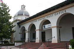
- National Register of Historic Places in Redlands: A. K. Smiley Public Library, Beverly Ranch (Fisk-Burgess house), Kimberly Crest, the Mill Creek Zanja, the Redlands Central Railway Company Car Barn, the Redlands Santa Fe Depot District, the Smiley Park Historic District, and the US Post Office—Redlands Main.[49]
- California Historical Landmarks in Redlands: A.K. Smiley Library (994), Kimberly Crest (1019), the San Bernardino de Sena Estancia (42), and the Zanja (43). The Barton house has been nominated and is pending approval.[50]
- Redlands Heritage Awards: a list of numerous Victorian, Craftsman, etc. homes in Redlands.[51]
- The Barton School House, built in 1877, is the oldest building in Redlands. The historic elementary school closed down in the 1960s and deteriorated at its Nevada Street location. By early 2008, construction had become huge in the area surrounding it and the land the property sat on was purchased for development. Instead of destroying the building, the company paid to move it to Orange Avenue at The Grove School's farm campus. The building was moved in three pieces and has been renovated and remodeled. It is now owned and operated by The Grove School.
- Victorian Structures
Edwards Mansion 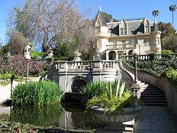
Kimberly Crest 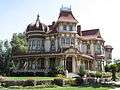
Morey Mansion
- Edwards Mansion, built in 1890 by one of the founders of Redlands, Citrus grower James S. Edwards, this structure was originally used not as a family home but as a boarding house. Mr. Edwards used standard plans and built the house on a small rise on Cajon St. from where the young orange groves he planted could be seen in every direction. Eventually the Edwards family moved into the structure and occupied it continually until 1958 when Mrs. Edwards died. Almost a decade later, Plymouth Village acquired the home and used it for their business offices until it was acquired by the Edwards Mansion complex in 1973 for one dollar. The structure was moved to its current location off of Interstate 10 and restored to serve its current purpose as a popular wedding location.[52]
- Kimberly Crest House and Gardens, built in 1897 this French château-style home is preserved by the Kimberly-Shirk Association that was formed for that purpose. This three-story chateau is over 7,000 square feet (650 m2) and was originally built for Mrs. Cornelia A. Hill. In 1905 J. Alfred Kimberly (co-founder of Kimberly-Clark) purchased this home for his family. His daughter, Mary Kimberly Shirk, lived in the home until her death in 1979. Before she passed the majority of the grounds were sold to the City of Redlands to become a botanical park, now known as Prospect Park. After her death, the home was left to "the people of Redlands" and the monies from the sale of the park were used to create the Kimberly-Shirk Association that cares for the home and provides tours within.[53]
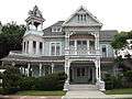
- Morey Mansion, built in 1890 with the proceeds from the sale of Sarah Morey's citrus nursery there is no known architect to this beautiful structure. David and Sarah Morey moved to Redlands in 1882 where David did carpentry work on many of the local structures and the Big Bear dam. Sarah started a citrus nursery using seeds from local growers that became one of the foremost citrus nurseries in the area. She eventually sold it and used 1/2 the proceeds to build their family home. After the Morey family sold the house it was alternatively a bed and breakfast and private residence and now serves both functions. Located on the bluffs overlooking San Timoteo Canyon it is known for its commanding view.[54]
Museums
- The Lincoln Shrine is a museum and research facility located in Smiley Park and dedicated to Abraham Lincoln and the American Civil War.[55]
- Redlands Historical Museum, located inside the A. K. Smiley Library on the grounds of Smiley Park in downtown Redlands. The Museum will refurbish the old 1940 City Hall, now used as the Redlands Police Department as their new Museum Center. The Heritage Center holds various pictures, pamphlets, maps, yearbooks, newspapers, manuscripts and books all relating to the rise of Redlands as a navel orange producing mecca to the close knit community it has become today.[56]
- Redlands Historical Glass Museum holds displays of American Glassware dating from the early 19th century to contemporary times. Displays include, glass from Heisey, Cambridge, Fenton Art Glass Company, Fostoria, and Sandwich factories as well as those that produced depression-era glassware. Items on display include candlesticks, compotes, milk glass, stems, bowls, historical plates, salts, kerosene lamps-and even several items from the estate of Liberace.[57]
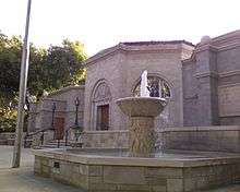
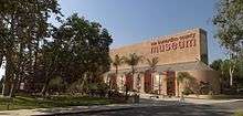
- San Bernardino County Museum (SBCM), is a regional museum with exhibits and collections in cultural and natural history. Special exhibits, the Exploration Station live animal discovery center, extensive research collections, and public programs for adults, families, students, and children are all part of the museum experience. The SBCM also runs the San Bernardino de Sena Estancia.[58]
Theater and music
- Fox Event Center is located in downtown Redlands. The historic 1928 Fox Theatre offers dinner theater, film festivals, art shows, comedy shows, open mic nights, and concerts featuring different music genres including acoustic, blues, rock, jazz and classical.[59]
 LifeHouse Theater
 - The LifeHouse Theater is an interdenominational (Judeo-Christian) community theater, founded in 1993.[60]
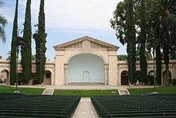
- Redlands Bowl Summer Festival is the oldest continuously running music festival in Southern California, and the United States, where no admission is charged. Performances feature symphony concerts, band, dance troupes, musical and opera. It is located in Smiley Park in the Redlands Bowl amphitheatre.[61]
- Redlands Chamber Music Society holds five performances of visiting artists at the Frederick Lowe Performance Hall each year.[62]
- Redlands Footlighters is a volunteer community theater founded in 1945 that produces five shows each season.[63]
- Redlands Symphony performs through the academic year at the University of Redlands and during the summer at the Redlands Bowl.[64]
- Redlands Theatre Festival is a summer volunteer community theater festival founded in 1972 that produces around five plays in repertory that feature a different production each night which typically include: a major Broadway musical, an Off-Broadway musical, a contemporary drama, a recent Broadway release and a period piece. The season begins the second week of July and continues through the third week of August. Performances are held in the Avice Meeker Sewall Theater (an outdoor amphitheater) in Prospect Park.[65]
- Redlands Shakespeare Festival occurs each May at the Redlands Bowl outdoor amphitheater in Smiley Park, and features full-scale repertory performances, a University Lecture Series, an Educational Workshop Series, Director’s Insight Series, and other special events.[66]
Open spaces
The city of Redlands owns and operates 24 public parks totaling more than 143 acres (0.58 km2):
- Brookside Park: a 9.2-acre (37,000 m2) neighborhood park with picnic and playground facilities. (Brookside Avenue between Terracina Boulevard and Bellevue Avenue)
- Caroline Park: a 16.8-acre (68,000 m2) nature park with trails and open space planted with native California plants and a water conservation garden. It houses a large variety of animals. Especially active near sundown. (Sunset Drive and Mariposa Drive)
- Community Park: an 18.2-acre (74,000 m2) park with lighted baseball fields, tennis courts, picnic and playground facilities. (San Bernardino Avenue and Church Street)
- Crafton Park: a 7.5-acre (30,000 m2)-neighborhood park with lighted soccer field, picnic and playground facilities. (Wabash Avenue and Independence Avenue)
- Ed Hales Park: a .7-acre (2,800 m2) downtown park with picnic facilities. (State Street and Fifth Street)
- Jennie Davis Park: a 5.2-acre (21,000 m2) neighborhood park with picnic and playground facilities. (Redlands Boulevard and New York Street)
- Ford Park: a 27-acre (110,000 m2) park with two ponds for fishing, lighted tennis courts, dog park, picnic and playground facilities. (Redlands Boulevard and Ford Street)
- Franklin Park: a .6-acre (2,400 m2) natural open space area. (Garden Street and Franklin Avenue)
- Prospect Park: an 11.4-acre (46,000 m2) natural park with trails and picnic facilities. The park contains the Avice Meeker Sewall Theater, an outdoor amphitheater with seating for 407. (Cajon Street and Highland Avenue)
- San Timoteo Canyon Nature Preserve: a 40-acre (160,000 m2) natural preserve facility. (San Timoteo Canyon Road and Alessandro Road)
- Simonds Parkway: a .9-acre (3,600 m2) neighborhood park. (Garden Street and Rossmont Drive)
- Smiley Park: a 9.2-acre (37,000 m2) park at the Redlands Civic Center. This park is home to A.K. Smiley Public Library, a facility listed on the National Register of Historic Places; the Lincoln Memorial Shrine, built in 1932, containing the largest collection of Abraham Lincoln memorabilia west of the Mississippi River; and the Redlands Bowl, an outdoor amphitheater with seating for approximately 4,000 where summer concerts are performed each Tuesday and Friday evening during July and August. (Eureka Street and Vine Street). The Lincoln Shrine is host to the annual Boy Scout Pilgrimage to the Lincoln Shrine.[67]
- Sylvan Park: a 23.3-acre (94,000 m2) park with softball field, horseshoe pits, volleyball area, group and individual picnic areas and playground facilities. (Colton Avenue and University Street)
- Texonia Park: a 10.7-acre (43,000 m2) neighborhood park with lighted softball field, basketball courts, picnic and playground facilities. (Texas Street and Lugonia Avenue)
- Redlands Sports Park: The 120-acre (0.49 km2) facility includes soccer fields, softball fields, group picnic facilities, playground and recreations elements. (Wabash Avenue and San Bernardino Avenue) by Redlands Municipal Airport
The Redlands Conservancy has established 10 city-approved trails:[68]
- Bluffs Trail
- Caroline Park Trail
- East Valley Corridor Bikeway
- Garden-Mariposa Trail
- Gold Hill/Panorama Point Trail
- Oak Ridge and Oakmont Trails
- Orange Blossom Rail Trail
- Teddy's Trail
- San Timoteo Creek Flood Control Trail
- Sylvan Park Trail
Cemetery
The Hillside Memorial Park Cemetery, established in 1886 as a private cemetery, was acquired by the city in 1918.[69][70] Notable burial include actress Gloria Holden,[71] television journalist Robert Pierpoint,[72] and author Charles Nordhoff.[70][73]
Local attractions
- Citrus Plaza: a large open-air shopping center.
- Hangar 24 Craft Brewery: Regional Craft Brewery with Tours and Tasting located at the Redlands Municipal Airport.
- Redlands Mall: a former indoor shopping mall, now closed (except for a chain drug store), scheduled for demolition, to be replaced by a boutique hotel and residential housing.
- Pharaoh's Adventure Park: 20-acre (81,000 m2) theme park which re-opened in late 2010. The park incorporates Egyptian themes, and includes a Go-Cart raceway, miniature golf, bumper cars, an amphitheater, and a water park. The park has been used in television filming, including a 2006 episode of C.S.I. Las Vegas featuring a rollercoaster accident.
Local events
- Community July 4 includes picnic at Sylvan Park with more than 50 service and civic clubs, a parade, and the annual fireworks spectacular at Ted Runner Stadium with jet flyovers, skydivers, July 4 Band and fireworks – it is one of the largest Independence Day celebrations in California.[74]
- Lincoln Pilgrimage, held each February, attracts more than a thousand Scouts and other youth to honor the ideals and life of President Abraham Lincoln, and is coordinated by the Grayback District of the California Inland Empire Council, Boy Scouts of America.[67]
- Redlands Bicycle Classic, a cycling stage race, has been held in Redlands each spring (usually in March) since 1985.[75]
- Redlands Triathlon/Duathlon, your choice of a 5K run/10 mile bike/100 yard swim or a 5K run/10 mile bike/5K run-walk through Redlands held each February.[76]
- Run through Redlands, established in 1984, one of the biggest running events in the Inland Empire Area including a kinder-dash, 5K, 10K, and a half-marathon, is held each March.[77]
- Redlands Bowl Summer Music Festival, established in 1924, is an outdoor performing arts festival that runs every summer.[78]
Local references
- Jardien's Dream, a young adult novel published in October 2009, takes place in Redlands.[79]
- The Rocketeer – in the Disney movie version, the heroine, Jenny, hails from Redlands.[80]
- According to the Los Angeles Times, the town in Tamara Thorne's horror novel Bad Things is based on Redlands.[81]
- In Frank Zappa's song "San Ber'dino", the lyrics comment that the song "ain't talkin' about the Redlands, no no."[82]
Religion
A variety of religions have a presence in Redlands, including a number of Christian faiths, Judaism, and Islam. There is a Redlands Area Interfaith Council.[83]
Redlands has a large Mormon and Seventh-day Adventist population each, nearby is the town of Loma Linda.
A Baptist university, the University of Redlands is the "center" of California's "Bible Belt" stretching from Kern County through the High Desert down to San Diego County and may include Orange County with its strongly conservative Republican suburbs.
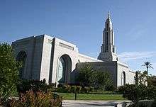
The Redlands California Temple is the 116th operating temple of The Church of Jesus Christ of Latter-day Saints (LDS Church) and one of four LDS temples in Southern California. The LDS Church also has multiple chapels in Redlands. It has the San Bernardino Mission and also another in Riverside.
Congregation Emanu El, formerly located in nearby San Bernardino, in 2013 dedicated its new building on Ford Street in Redlands. The Congregation claims to trace its history back to the 1850s.
Notable people
- Matt Andriese, professional baseball player for Tampa Bay Rays
- Ashley Argota, actress
- Lil Xan, rapper
- Joan Baez, folk singer and songwriter[84]
- Brian Billick, head coach of NFL's Baltimore Ravens 1999-2007, television commentator
- Harry Blackstone, Jr., professional magician[85]
- Hugh "Lumpy" Brannum, actor, Mr. Green Jeans on Captain Kangaroo show
- Tyler Chatwood, Current MLB starting pitcher for the Chicago Cubs.
- Barney Childs, composer
- Ryan Christenson, MLB player for four teams, minor-league manager
- Jack Dangermond, founder of ESRI
- Tyler Clary, born in Redlands, won men's 200-meter backstroke at 2012 London Olympics[86]
- Landon Donovan, professional soccer player for Los Angeles Galaxy, US National Team and Club León.
- Skip Ewing, country music star
- James Fallows, journalist for The Atlantic Monthly
- Davey Faragher, musician with Elvis Costello
- John Mack Faragher, American historian and author[87]
- Helen G. Fisk (1895–1986), vocational services executive
- Tommy Hanson, professional baseball player for Los Angeles Angels
- Johnny Hickman, musician, guitarist for Cracker
- Taylor Horn, singer-songwriter and actress
- Brion James, actor in films such as Blade Runner and 48 Hrs.
- Patrick Johnson, professional football player Baltimore Ravens
- John Jorgenson, guitar virtuoso with Desert Rose Band, the Hellecasters, the John Jorgenson Quintet, and six-year member of Elton John's tour band; attended Moore Junior High, and Redlands High School
- James LeGros, actor
- Harlan Lewis, Award winning botanist and UCLA Dean of Life Sciences
- Jerry Lewis, former congressman, ranking member of the House Appropriations Committee
- David Lowery, musician, lead singer for Camper Van Beethoven and Cracker
- Greta Morris, former United States Ambassador to Republic of the Marshall Islands
- Doris Niles, dancer, choreographer
- Kye Palmer, trumpet player and studio musician
- DeWayne Patterson, football player
- Leah Pritchett, NHRA Top Fuel driver
- Michael A. Rogers, author, futurist
- Benji Schwimmer, winner of second season of So You Think You Can Dance
- Lacey Schwimmer, professional dancer on Dancing with the Stars
- Mark R. Shepherd, Democratic Party activist and politician
- J.D.B. Stillman, physician, author, first American governor of California
- Stephen Shadegg, political consultant in Phoenix, Arizona, associated in particular with Barry Goldwater; reared in Redlands
- Naomi Smalls, drag queen and finalist on RuPaul's Drag Race Season 8
- Dave Stockton, professional golfer, two-time PGA Championship winner
- Dan Straily, MLB pitcher for Miami Marlins
- Tim Tackett, martial artist
- Mark Teahen, Major League Baseball player 2005-11
- Joan Tewkesbury, film director
- The Tornadoes, surf rock band featured on Pulp Fiction soundtrack
- Tom Wheeler, 31st Chairman of Federal Communications Commission
- Josh Whitesell, MLB player for Arizona Diamondbacks
Sister cities
Redlands has two sister cities, as designated by Sister Cities International:


See also
References
- ↑ Gold, Scott (November 25, 2001). "'Jewel of Inland Empire' Is Not Cherished by All". Los Angeles Times. Retrieved January 23, 2015.
- ↑ "California Cities by Incorporation Date". California Association of Local Agency Formation Commissions. Archived from the original (Word) on February 21, 2013. Retrieved August 25, 2014.
- 1 2 3 "City Council Members". City of Redlands. Retrieved January 23, 2015.
- ↑ "2016 U.S. Gazetteer Files". United States Census Bureau. Retrieved Jun 28, 2017.
- ↑ "Redlands". Geographic Names Information System. United States Geological Survey. Retrieved November 4, 2014.
- 1 2 3 4 5 "Redlands (city) QuickFacts". United States Census Bureau. Retrieved February 8, 2015.
- 1 2 "Population and Housing Unit Estimates". Retrieved June 9, 2017.
- ↑ "ZIP Code(tm) Lookup". United States Postal Service. Retrieved November 12, 2014.
- ↑ "Number Administration System – NPA and City/Town Search Results". Archived from the original on September 29, 2007. Retrieved February 20, 2007.
- ↑ Robinson, W.W. (1962). The Story of San Bernardino County. San Bernardino, California: Title Insurance and Trust Company.
- ↑ Hinckley, Edith B. (1951). On the Banks of the Zanja: The Story of Redlands. Claremont, California: The Saunders Press. p. 42.
- ↑ Swett, Ira L., "Tractions of the Orange Empire", Interurbans Special Number Forty-One, Interurbans Magazine, Los Angeles, California, August 1967, Chapter 7, Redlands The Beautiful, page 61.
- ↑ "About the City of Redlands". Redlands.edu. Retrieved July 16, 2014.
- ↑ Craig, Scipio, "HURRAH! For the City of Redlands ! ! – Incorporation Carried by a Rousing Majority", The Citrograph, Redlands, California, Extra, November 27, 1888, Volume 3, Number -, front page.
- ↑ Swett, Ira L., "Tractions of the Orange Empire", Interurbans Special Number Forty-One, Interurbans Magazine, Los Angeles, California, August 1967, Chapter 7, Redlands The Beautiful, pages 60–61.
- ↑ "Citrograph Printing Co. Redlands CA Original Print Shop Est. 1887". Citrograph Printing Co.
- ↑ Swett, Ira L., "Tractions of the Orange Empire", Interurbans Special Number Forty-One, Interurbans Magazine, Los Angeles, California, August 1967, Chapter 7, The Horse Cars of Redlands, page 34.
- ↑ Swett, Ira L., "Tractions of the Orange Empire", Interurbans Special Number Forty-One, Interurbans Magazine, Los Angeles, California, August 1967, Chapter 7, Official Corporate (PE) Histories – The Redlands Street Railway Company, page 35.
- 1 2 3 4 Staff, "Historic Redlands Lighting System Today 50 Years Old - Street Illumination Proved Feasibility Of World's First Long Transmission Line", The San Bernardino Daily Sun, San Bernardino, California, Friday 6 August 1943, Volume 49, page 12.
- ↑ Swett, Ira L., "Tractions of the Orange Empire", Interurbans Special Number Forty-One, Interurbans Magazine, Los Angeles, California, August 1967, Chapter 7, The Redlands Street Railway Company, page 54.
- ↑ Swett, Ira L., "Tractions of the Orange Empire", Interurbans Special Number Forty-One, Interurbans Magazine, Los Angeles, California, August 1967, Chapter 21, Pacific Electric Waxes and Wanes, page 235.
- ↑ Crump, Spencer, "Ride the Big Red Cars – The Pacific Electric Story", Trans-Anglo Books, a division of Interurban Press, Glendale, California, 1983, Seventh Edition – Summer 1988, LCCN 77-72017, ISBN 0-87046-047-1, page 65.
- ↑ Crump, Spencer, "Ride the Big Red Cars – The Pacific Electric Story", Trans-Anglo Books, a division of Interurban Press, Glendale, California, 1983, Seventh Edition – Summer 1988, LCCN 77-72017, ISBN 0-87046-047-1, page 95.
- ↑ "Pacific Electric San Bernardino Line". www.erha.org.
- ↑ Swett, Ira L., "Tractions of the Orange Empire", Interurbans Special Number Forty-One, Interurbans Magazine, Los Angeles, California, August 1967, Chapter 7, The Redlands Interurban Line, page 85.
- ↑ Staff, "Rail Service On Interurban Lines Dropped - Abandonment Effective Monday Of Car Service; Busses To Be Substituted", The San Bernardino Daily Sun, San Bernardino, California, Sunday 19 July 1936, pages 13, 23.
- ↑ Staff, "Late Mail To Result From P.E. Stoppage", The San Bernardino Daily Sun, San Bernardino, California, Sunday 19 July 1936, page 15.
- 1 2 "Golden Jubilee, Redlands, California: 1888-1938", Citrograph Printing Company, Redlands, California, 1938.
- ↑ http://www.ieeeghn.org/wiki/index.php/Milestones:Mill_Creek_No._1_Hydroelectric_Plant,_1893 IEEE Milestones, Mill Creek No. 1 Hydroelectric Plant, retrieved 2012 Jan 4
- ↑ "Historic Citrus Preservation". City of Redlands. Retrieved March 31, 2015.
- ↑ Workers of the Writers' Program (1941). Los Angeles: A Guide to the City and its Environs. Hastings House Press.
- ↑ Vicki L. Ruiz. Cannery Women, Cannery Lives. University of New Mexico Press, 1987, pp. 81–83.
- ↑ "The Lincoln Memorial Shrine – A Lincoln Museum in Redlands, CA". www.lincolnshrine.org.
- ↑ "Morey Mansion". moreymansion.com.
- 1 2 "ESRI: Redlands Brochure (2007) –" (PDF). Retrieved January 5, 2007.
- ↑ "Redlands, California Köppen Climate Classification (Weatherbase)". Weatherbase.
- ↑ "Census of Population and Housing". Census.gov. Retrieved June 4, 2015.
- ↑ "2010 Census Interactive Population Search: CA - Redlands city". U.S. Census Bureau. Retrieved July 12, 2014.
- ↑ "American FactFinder". United States Census Bureau. Retrieved 2008-01-31.
- ↑ "State of California, Department of Finance, E-1 Population Estimates for Cities, Counties and the State with Annual Percent Change — January 1, 2007 and 2008. Sacramento, California, May 2008". Dof.ca.gov. Archived from the original on February 17, 2011. Retrieved February 22, 2011.
- ↑ "Gill Batteries". Gill Batteries. Retrieved February 22, 2011.
- ↑ "Communities of Interest - City". California Citizens Redistricting Commission. Retrieved September 27, 2014.
- ↑ "Statewide Database". UC Regents. Retrieved November 23, 2014.
- ↑ "By-District City Council Election System - City of Redlands". cityofredlands.org.
- ↑ "Christ the King REDLANDS Pre-K". Ctkredlands.org. Retrieved February 22, 2011.
- ↑ Staff, "Hearing Scheduled On Freeway Route", San Bernardino Sun, Thursday 24 January 1957, Volume 63, Number 125, page 22.
- ↑ Moore, Frank Ensor (1995). "Redlands Astride the Freeway: The Development of Good Automobile Roads". Redlands, California: Moore Historical Foundation. ISBN 0-914167-07-3.
- ↑ "Imperfect Rail Solution". The Press-Enterprise. May 16, 2011. Archived from the original on November 6, 2011. Retrieved November 5, 2011.
- ↑ "National Register of Historic Place Website".
- ↑ "California Historical Landmarks Website".
- ↑ "Redlands Historical Society Website".
- ↑ "Edwards Mansion Website". Archived from the original on December 30, 2007.
- ↑ "Kimberly Crest Website". Archived from the original on April 5, 2008.
- ↑ "Morey Mansion Website". Archived from the original on September 6, 2007.
- ↑ "Lincoln Shrine Website".
- ↑ "Redlands Historical Museum". Redlands Historical Museum. Retrieved February 22, 2011.
- ↑ "Redlands Historical Glass Museum". Historicalglassmuseum.com. August 2, 2005. Retrieved February 22, 2011.
- ↑ "San Bernardino County Museum". Co.san-bernardino.ca.us. Archived from the original on February 17, 2011. Retrieved February 22, 2011.
- ↑ "Fox Event Center Website". Archived from the original on September 20, 2011.
- ↑ "Lifehouse Theater Website".
- ↑ "Redlands Bowl Website".
- ↑ "Redlands Chamber Music Society Website".
- ↑ "Redlands Footlighters Website".
- ↑ "Redlands Symphony Website".
- ↑ "Redlands Theatre Festival Website".
- ↑ "Redlands Shakespeare Festival Website".
- 1 2 "Redlands Events, Lincoln Pilgrimage".
- ↑ "Redlands Conservancy Website".
- ↑ U.S. Geological Survey Geographic Names Information System: Hillside Cemetery
- 1 2 "Hillside Memorial Park Cemetery - City of Redlands". www.cityofredlands.org.
- ↑ Gloria Holden at Find a Grave
- ↑ Robert C. Pierpoint at Find a Grave
- ↑ Charles Nordhoff at Find a Grave
- ↑ "Redlands Events Website". Archived from the original on November 14, 2011.
- ↑ "Redlands Bicycle Classic Website".
- ↑ "Redlands Events Website".
- ↑ "Redlands Events Website".
- ↑ "About Us". redlandsbowl.org. Retrieved 2017-11-08.
- ↑ "Jardien's Dream". Jardiensdream.blogspot.com. Retrieved February 22, 2011.
- ↑ "Internet Movie Data Base Website".
- ↑ Masello, Robert (28 October 2004). "The Skeleton Crew". Los Angeles Times. Retrieved 20 April 2015.
- ↑ "Frank Zappa - San Ber'dino Lyrics - MetroLyrics". www.metrolyrics.com.
- ↑ See Redlands Detailed Profile, Redlands Worship, and Religious Diversity News.
- ↑ Goldsmith, Barbara. "LIFE ON STRUGGLE MOUNTAIN". nytimes.com.
- ↑ Burleigh, Nina (October 29, 1989). "Take A Card, Any Card ..." Chicago Tribune. Retrieved March 25, 2015.
- ↑ "RD Facts Article". redlandsdailyfacts.com.
- ↑ SCOTT, JANNY (September 25, 1993). "Times Announces Winners of Annual Book Awards". Los Angeles Times. Retrieved 24 July 2018.
External links
| Wikimedia Commons has media related to Redlands, California. |
Places adjacent to Redlands, California | |
|---|---|