Kramer Junction, California
| Kramer Junction | |
|---|---|
| Unincorporated community | |
| Nickname(s): Four Corners | |
| Country | United States |
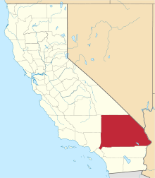
| State | California |
| County | San Bernardino |
| Population | |
| • Total | 2,231 |
| Time zone | PST |
| ZIP code | 93516 |
| Area code(s) | 760 |

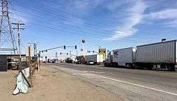
Kramer Junction (also known as "Four Corners" or "Sludge Junction") is an unincorporated community in San Bernardino County, California. Kramer Junction is located in the Mojave Desert at the intersection of U.S. Route 395 and State Route 58, 2.3 miles (3.7 km) east of Kramer.[1] As of the 2000 census, Kramer Junction had a total population of 2,231.[2]
The intersection of US 395 and California State Route 58 has long been an infamous zone of highway backups; a nearly $200 million Caltrans project to bypass this intersection is under construction as of 2018[3] (and expected to be eventually part of SR 58 being the long-anticipated westward extension of I-40 from its current terminus at Barstow, through Bakersfield, to an interchange with I-5).
Solar Energy Generating Systems sites SEGS III-VII are located less than a mile to the northwest.
The United States Air Force once maintained a communications relay station east of Kramer Junction at Hawes airfield, known as the Hawes Radio Tower, that had an antenna tower in excess of 1,200 feet tall. This tower was removed in the 1980s.
References
- ↑ "Kramer Junction". Geographic Names Information System. United States Geological Survey.
- ↑ "USA.com : Location information of the United States". Zipareacode.net. Retrieved 2013-10-24.
- ↑ Orr, Patti (July 13, 2018). "Kramer Junction Expressway Project Update". Mojave Desert News. Retrieved 2018-09-02.
Coordinates: 34°59′33″N 117°32′30″W / 34.99250°N 117.54167°W