Rødøy
| Rødøy kommune | |||
|---|---|---|---|
| Municipality | |||
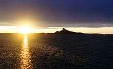
 View of the island of Hestmona | |||
| |||
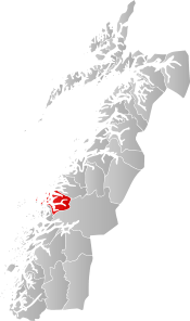 Rødøy within Nordland | |||
| Coordinates: 66°35′36″N 13°21′34″E / 66.59333°N 13.35944°ECoordinates: 66°35′36″N 13°21′34″E / 66.59333°N 13.35944°E | |||
| Country | Norway | ||
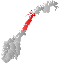
| County | Nordland | ||
| District | Helgeland | ||
| Established | 1838 | ||
| Administrative centre | Vågaholmen | ||
| Government | |||
| • Mayor (2003) | Olav Terje Hoff (Sp) | ||
| Area | |||
| • Total | 711.29 km2 (274.63 sq mi) | ||
| • Land | 686.16 km2 (264.93 sq mi) | ||
| • Water | 25.13 km2 (9.70 sq mi) | ||
| Area rank | #158 in Norway | ||
| Population (2017) | |||
| • Total | 1,267 | ||
| • Rank | #371 in Norway | ||
| • Density | 1.8/km2 (5/sq mi) | ||
| • Change (10 years) | -5.7% | ||
| Demonym(s) | Rødøyfjerding[1] | ||
| Time zone | UTC+01:00 (CET) | ||
| • Summer (DST) | UTC+02:00 (CEST) | ||
| ISO 3166 code | NO-1836 | ||
| Official language form | Neutral | ||
| Website |
rodoy | ||
Rødøy is a municipality in Nordland county, Norway. It is part of the Helgeland traditional region. The administrative centre of the municipality is the village of Vågaholmen. Other villages include Gjerøy, Jektvika, Kilboghamn, Melfjorden, Oldervika, Sørfjorden, and Tjong. The municipality consists of many islands to the west of Norway's second biggest glacier, Svartisen.
The 711-square-kilometre (275 sq mi) municipality is the 158th largest by area out of the 422 municipalities in Norway. Rødøy is the 371st most populous municipality in Norway with a population of 1,267. The municipality's population density is 1.8 inhabitants per square kilometre (4.7/sq mi) and its population has decreased by 5.7% over the last decade.[2]
General information


The municipality of Rødøy was established on 1 January 1838 (see formannskapsdistrikt). On 1 January 1884, the northern district of Rødøy was separated to form the new municipality of Meløy. This division left Rødøy with 1,945 residents. The borders of the municipality have not changed since that time.[3]
Name
The Old Norse form of the name was Rauðøy. The first element is rauðr which means "red" (probably referring to the color of the rocks of the island) and the last element is øy which means "island".[4]
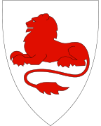
Coat-of-arms
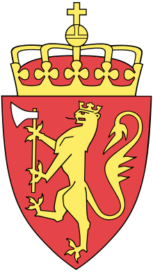
The coat-of-arms is from modern times; they were granted on 12 February 1988. The arms show a red lion on a silver background symbolizing the mountain called Rødøyløva (English: the lion of Rødøy) because its profile resembles a lion. (See picture). It is not the highest mountain in the municipality, however, Blokktinden is one that is higher.[5]
Churches
The Church of Norway has two parishes (sokn) within the municipality of Rødøy. It is part of the Nord-Helgeland prosti (deanery) in the Diocese of Sør-Hålogaland.
| Parish (Sokn) | Church Name | Location of the Church | Year Built |
|---|---|---|---|
| Rødøy | Rødøy Church | Rødøya | 1885 |
| Rødøy indre | Sørfjorden Church | Sørfjorden | 1916 |
| Tjongsfjorden Church | Tjong | 1962 |
Geography
The eastern part of Rødøy is located on the mainland, just east of the Saltfjellet mountain range. The rest of the municipality consists of islands to the west including Gjerdøya, Hestmona, Myken, Nesøya, Rangsundøya, Renga, and Rødøya. The westernmost part of the municipality is the Myken islands in the Vestfjorden, where the Myken Lighthouse is located.
The Tjongsfjorden is located in the northern part of the mainland of Rødøy, just north of the mountain Blokktinden. The Melfjorden is located in the southern part of the mainland, flowing out of the Saltfjellet–Svartisen National Park.
Government
All municipalities in Norway, including Rødøy, are responsible for primary education (through 10th grade), outpatient health services, senior citizen services, unemployment and other social services, zoning, economic development, and municipal roads. The municipality is governed by a municipal council of elected representatives, which in turn elect a mayor.
Municipal council
The municipal council (Kommunestyre) of Rødøy is made up of 17 representatives that are elected to four year terms. Currently, the party breakdown is as follows:[6]
| Party Name | Name in Norwegian | Number of representatives | |
|---|---|---|---|
| Progress Party | Fremskrittspartiet | 1 | |
| Centre Party | Senterpartiet | 6 | |
| Local Lists | Lokale lister | 10 | |
| Total number of members: | 17 | ||
References
- ↑ "Navn på steder og personer: Innbyggjarnamn" (in Norwegian). Språkrådet. Retrieved 2015-12-01.
- ↑ Statistisk sentralbyrå (2017). "Table: 06913: Population 1 January and population changes during the calendar year (M)" (in Norwegian). Retrieved 2017-09-19.
- ↑ Jukvam, Dag (1999). "Historisk oversikt over endringer i kommune- og fylkesinndelingen" (PDF) (in Norwegian). Statistisk sentralbyrå.
- ↑ Rygh, Oluf (1905). Norske gaardnavne: Nordlands amt (in Norwegian) (16 ed.). Kristiania, Norge: W. C. Fabritius & sønners bogtrikkeri. p. 163.
- ↑ "Kommunevåpenet". Rødøy kommune. Archived from the original on 2016-03-04. Retrieved 2012-02-03.
- ↑ "Table: 04813: Members of the local councils, by party/electoral list at the Municipal Council election (M)" (in Norwegian). Statistics Norway. 2015.
External links
- Municipal fact sheet from Statistics Norway (in Norwegian)
| Wikimedia Commons has media related to Rødøy. |

| |||||||||||||||||
| |||||||||||||||||