Qasr Abu Samrah
| Qasr Abu Samrah قصر أبو سمرة | |
|---|---|
 Qasr Abu Samrah | |
| Coordinates: 35°21′16″N 36°58′19″E / 35.35444°N 36.97194°E | |
| Country |
|
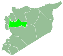
| Governorate | Hama Governorate |
| District | Hama |
| Subdistrict | Suran |
| Population (2004)[1] | |
| • Total | 849 |
| Time zone | UTC+2 (EET) |
| • Summer (DST) | UTC+3 (EEST) |
Qasr Abu Samrah (Arabic: قصر أبو سمرة) is a village and archaeological site in Syria, administratively a part of the Hama District of the Hama Governorate, located 31 kilometers (19 mi) northeast of Hama city. Nearby localities include Zughba to the north, al-Tulaysiyah to northwest, al-Junaynah to the west, Fan al-Shamali and Qasr al-Makhram to the southwest, Duma to the southeast, and al-Hazim to the northeast.[2]
According to the Syria Central Bureau of Statistics, Qasr Abu Samrah had a population of 849 in the 2004 census.[1] Its inhabitants are predominantly Alawites.
Qasr Abu Samrah contains the ruins of a Byzantine-era tower and church, both of them not well-preserved. The church was built completely from basalt. One row of five columns, out of the original two, remains standing,large doorway of the structure.[3]
References
- 1 2 General Census of Population and Housing 2004. Syria Central Bureau of Statistics (CBS). Hama Governorate. (in Arabic)
- ↑ "Qasr Abu Samrah - Wikimapia". Wikimapia.
- ↑ Boulanger, 1966, p. 376.
Bibliography
- Boulanger, Robert (1966). The Middle East, Lebanon, Syria, Jordan, Iraq, Iran. Hachette.