Western Water Catchment
| Western Water Catchment | |
|---|---|
| Planning Area | |
| Other transcription(s) | |
| • Chinese | 西部集水区 |
| • Pinyin | Xībù jíshuǐqū |
| • Malay | Kawasan Tadahan Air Barat |
| • Tamil | மேற்கத்திய நீர் நீர்ப்பிடிப்பு |
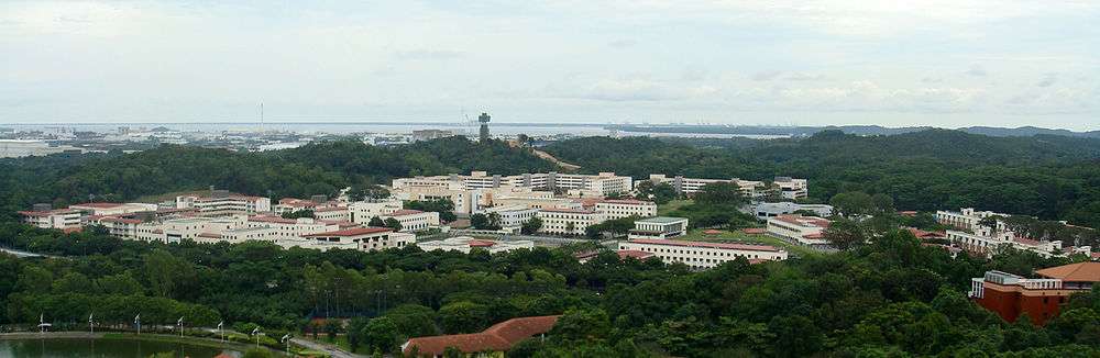 _participate_in_a_live-fire_exercise.jpg) From top to bottom: An overview of Pasir Laba Camp, soldiers at the Murai Urban Training Facility | |
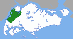 Western Water Catchment Area | |
 Western Water Catchment Location in Singapore | |
| Coordinates: 1°23′13″N 103°41′31″E / 1.387°N 103.692°ECoordinates: 1°23′13″N 103°41′31″E / 1.387°N 103.692°E | |
| Country |
|
| Region |
|
| CDC | |
| Town councils |
|
| Constituencies | |
| Government | |
| • Mayor |
South West CDC |
| • Members of Parliament |
Chua Chu Kang GRC
|
| Area[1] | |
| • Total | 69.5 km2 (26.8 sq mi) |
| Area rank | 1st |
| Population (2017)[1] | |
| • Total | 710 |
| • Rank | 38th |
| • Density | 10/km2 (26/sq mi) |
| • Density rank | 41st |
| Postal district | 24 |
The Western Water Catchment (Chinese: 西部集水区; Malay: Tadahan Air Bagian Barat; Tamil: மேற்கத்திய நீர் நீர்ப்பிடிப்பு) is a planning area located in the West Region of Singapore. The planning area borders Tuas and Pioneer to its south, Sungei Kadut, Choa Chu Kang and Tengah to its east, Jurong West to its southeast, Lim Chu Kang to its north and the Straits of Johor to its west.
The area currently houses four reservoirs, Tengeh Reservoir, Poyan Reservoir, Murai Reservoir and Sarimbun Reservoir. The Western Water Catchment is also a live-firing area in which it is used by the Singapore Armed Forces for training purposes. It is also a restricted area in which it is out of bounds to all members in the public except for military personnel from Pasir Laba Camp (South) and Sungei Gedong Camp (North).
The SAFTI Live Firing Area commenced operations in 1968 and was revamped in 2008, the eastern part began operations in 2002 and has been extended to Lim Chu Kang Tracks 11 and 13, but it has been remained unnamed, and it could be named 'Murai North'.
In the future, the area will be redeveloped into HDB towns cum forest park/Green Corridor, replacing Pulau Tekong as the island is still for military use, but is not in Land Use Plan 2030. There are many common names in the Western Water Catchment, including Bajau, Elephant Hill, Pasir Laba, Poyan, Murai, Sungei Gedong, Poyan North, Wrexham and Sarimbun.
Education
There is only one university in the Western Water Catchment which is Nanyang Technological University and National Institute of Education.
Camps and bases
There are three army camps in the Western Water Catchment. These include Pasir Laba Camp, Chua Chu Kang Camp at Lorong Danau and Sungei Gedong Camp. Additionally, there are various army firing ranges in the Western Water Catchment - Multi-Mission Range Complex, MATADOR Range, M203 Range, several SAFTI ranges and Poyan 300m Range. In Murai area, there are Murai Urban Live Firing Facility (MULFAC), Murai Urban Training Facility (MUTF) and MEXCON.
History
The SAFTI Live Firing Area was drawn out in 1967 but there are 504 signboards in the vicinity (the signboards do indicate 'Danger. Live Firing Area-KEEP CLEAR'). On the 14 July 1968, four villagers were killed in SAFTI Live Firing Area, which is very near to Kampong Berih, nine others were injured and seven other villagers sneaked into the Pasir Laba by sampans to pick durians and rambutans. They were injured by mortar rounds.[2] There are many cases of trespassers in the live firing area.[3][4]
Sentries are posted at 11 entrance points at Pasir Laba Camp to keep out trespassers. In September 2008, Training Resource Management Centre (TRMC) officers have standardised the live firing area signboards in all four languages, but in the later part of 2014, TRMC have added "Do Not Go Beyond This Line Without Authorisation - Live Firing in Progress" into the signboard. Keeping out trespassers into the live firing area have been discussed in Pasir Laba Camp's yearly general meetings. Those signboards are commonly found near NTU, Old Choa Chu Kang Road, Jalan Murai and Lim Chu Kang Road.[5]
Reservoirs
As of 2017, this water catchment has a total of 4 reservoirs.
Tengeh Reservoir
| Tengeh Reservoir | |
|---|---|
| Location | Western Water Catchment |
| Coordinates | 1°20′45″N 103°38′50″E / 1.34583°N 103.64722°E |
| Type | reservoir |
| Basin countries | Singapore |
Tengeh Reservoir (Chinese: 登格蓄水池) was formerly a river, Sungei Tengeh, which emptied into the Straits of Johor and was dammed to become a reservoir in the early 1980s (which is part of 'Western Water Catchment Scheme'). Construction of the reservoir began on 11 March 1977.[6]
Tengeh Reservoir is part of the SAFTI Live Firing Area (South) and has restricted access since 19 January 1992,[7] where possible there are two bridges at the ends of the vicinity. One is for road at the western end called "Wrexham Bridge", which is just a road bridge which connects Jalan Ahmad Ibrahim and Wrexham Drive, next to Tuas Checkpoint and one is for walking at the eastern end next to Pasir Laba Road and Tengeh Pumping Station. The western end of Pasir Laba Road is also located at the Elephant West Hill, where it becomes Wrexham Drive straightaway. The Chinese name of the reservoir sounds similar to the English one.
On 11 April 1991, there was a naked body of a woman floating in the reservoir.[8]
The southern side of Tengeh Reservoir is the Raffles Country Club, and the golf areas can see the reservoir clearly. The Raffles Country Club construction began on 29 October 1987. The government of Singapore has made the second large acquisition of land for the project by requiring Raffles Country Club to vacate its plot as the site offers the "most suitable location" to run the HSR tracks after the bridge crossing and to place the tunnel portal leading to the underground tunnels that would take the HSR to the Jurong East terminus. The site has to be vacated by July 31, 2018, to be used for HSR crossover tracks and a siding facility to temporarily house a train near the border for safety or operational reasons.[9]
On 3 November 2011, Public Utilities Board (PUB) and Economic Development Board (EDB), had decided to install floating solar panel at Tengeh Reservoir, which is part of S$11 million project. This is the first solar panel to be at the reservoir/river, and Western Water Catchment (Located at Wrexham Village).[10]
Poyan Reservoir
| Poyan Reservoir | |
|---|---|
| Location | Western Water Catchment |
| Coordinates | 1°22′37″N 103°39′50″E / 1.37694°N 103.66389°E |
| Type | reservoir |
| Basin countries | Singapore |
Poyan Reservoir (Chinese: 波扬蓄水池; Malay: Tadahan Air Poyan) was previously part of the river Sungei Poyan and its delta, which was dammed to become a reservoir. Sungei Poyan emptied into the Straits of Johor. Construction of the reservoir began in 11 March 1977.[6]
On 27 April 1984, two men were fined for trespassing into the live firing area.[11] On 14 February 1991, two men were fined $1,000 for fishing in a live firing area off Pasir Laba Road. On 17 August 1991, two RSAF pilots were killed at Poyan Reservoir.
It is part of SAFTI Live Firing Area (South), which has restricted access.[7] There are two restricted access gates at the end of Old Choa Chu Kang Road for connection to either end of Poyan Reservoir, as the road is quite narrow (is only accessible to pedestrians, bicycles and all military vehicles), together with the Lorong Danau (between Chua Chu Kang Camp and Jalan Sungei Poyan). Access to the reservoir was restricted since December 1999. At the end of Old Choa Chu Kang Road, there are several shared bicycles (Ofo and Obike) being parked from the bus stop to the narrow road.[12] The future training outfield, SAFTI City (formerly Poyan Court) will also be located there.[13]
At the reservoir, only the Mobility 3rd Generation raft is deployed to load and unload military vehicles when crossing from the western side to the eastern side.
Murai Reservoir
| Murai Reservoir | |
|---|---|
| Location | Western Water Catchment |
| Coordinates | 1°24′00″N 103°40′25″E / 1.40000°N 103.67361°E |
| Type | reservoir |
| Basin countries | Singapore |
Murai Reservoir (Chinese: 慕莱蓄水池; pinyin: Mù lái xù shuǐ chí) was formerly Sungei Murai, which was dammed in early 1980s, to create a reservoir. Construction work had begun on November 1977.[6]
It is part of SAFTI Live Firing Area (North), of which is restricted to only from the TRMC Operations Room.[7] The Murai Urban Training Facility is east of Murai Reservoir, which can be accessed through Jalan Murai from Lim Chu Kang Road, together with the Murai Urban Live Firing Facility (MULFF).[14]
There is also a road east of Murai Urban Training Facility which goes from Lim Chu Kang Road to Jalan Murai, called Murai Farmway. Only Murai Farmway and part of Jalan Murai is opened to the public. Access to the area and the reservoir has been restricted since October 1999. Murai North has four dirt roads named (with Lim Chu Kang Tracks 11 & 13).
Sarimbun Reservoir
| Sarimbun Reservoir | |
|---|---|
| Location | Western Water Catchment |
| Coordinates | 1°25′35″N 103°41′00″E / 1.42639°N 103.68333°E |
| Type | reservoir |
| Basin countries | Singapore |
Sarimbun Reservoir (Chinese: 莎琳汶蓄水池) was constructed by damming Sungei Sarimbun and widening of Sungei Karang, Sungei Hantu, and Sungei Sarimbun.[15] Construction work began in November 1977.[6]
It is part of SAFTI Live Firing Area in the north, which has restricted access since 19 January 1992 and only accessible through the TRMC Operations Room.[7] The public can cut through from Bahtera Track to enter Sarimbun Reservoir area.
Sarimbun was where General Tomoyuki Yamashita landed his troops during World War II, and was engaged in the Battle of Sarimbun Beach. Sarimbun is also home to many small vegetable and fruit farms and health farms. These farms are normally owned by local entrepreneurs. Sarimbun also hosts multiple permanent campsites, especially on Jalan Bahtera. These campsites include the Singapore Scout Association's Sarimbun Campsite, Girl Guides Singapore's Camp Christine, and Ministry of Education's Jalan Bahtera Adventure Centre.
Etymology
Sarimbun is a Malay place name, and existed probably since the early nineteenth century. The Franklin and Jackson's Plan of Singapore (1830) refers to Sungei Sarimbun, or Sarimbun River in Malay, as "Serimhone".
Rimbun means "luxuriant", "in great quantity" or "thick".
Other place names with Sarimbun include Pulau Sarimbun, a small island in the Straits of Johor off the coast at Sarimbun. Pulau Sarimbun is within the SAFTI Live Firing Area as shown in the map.
Islands
There are three islands in the Western Water Catchment - Pulau Bajau, Pulau Pergam and Pulau Sarimbun. Pulau Bajau is a hypsographic island within Poyan Reservoir. It is part of the SAFTI live firing area.
Etymology
Pulau Bajau means Bajau island, in which Bajau is an indigenous ethnic group residing in Sabah, eastern Malaysia, Brunei, Indonesia, the Philippines and parts of Sarawak.
References
- 1 2 Western Water Catchment (Planning Area, Singapore) - Population Statistics, Charts, Map and Location
- ↑ Trespassers at firing ground: 4 die, 15 July 1968
- ↑ Don't go picking fruits in the live firing area
- ↑ at firing 12 arrested for entering live firing area
- ↑ Pasir Laba Camp sentries
- 1 2 3 4 Work on Murai and Sarimbun Reservoir to start next month
- 1 2 3 4 SAFTI Live Firing Area map
- ↑ "Naked body of woman in the reservoir". The Straits Times. 11 April 1991.
- ↑ "Raffles Country Club to give up site for KL-Singapore High Speed Rail". AsiaOne.com. Retrieved 22 April 2017.
- ↑ "Archived copy". Archived from the original on 2012-12-24. Retrieved 2012-09-07. Floating solar panel at Tengeh Reservoir
- ↑ Two men were fined for trespassing into the live firing area
- ↑ The map of the access gate
- ↑ Fact Sheet: Next Gen SAFTI City to Revamp the SAFTI Training Area
- ↑ Murai Urban Live Firing Facility
- ↑ "Sarimbun". Lee Kong Chian Natural History Museum. The Digital Nature Archive of Singapore. Retrieved 22 February 2016.