Prestwich tram stop
| Prestwich | |||||||||||||||||||||||||||||||||||||||||||||||||||||||||||||||||||||||||||||||||||||||||||||||||||||||||||||
|---|---|---|---|---|---|---|---|---|---|---|---|---|---|---|---|---|---|---|---|---|---|---|---|---|---|---|---|---|---|---|---|---|---|---|---|---|---|---|---|---|---|---|---|---|---|---|---|---|---|---|---|---|---|---|---|---|---|---|---|---|---|---|---|---|---|---|---|---|---|---|---|---|---|---|---|---|---|---|---|---|---|---|---|---|---|---|---|---|---|---|---|---|---|---|---|---|---|---|---|---|---|---|---|---|---|---|---|---|---|
| Metrolink | |||||||||||||||||||||||||||||||||||||||||||||||||||||||||||||||||||||||||||||||||||||||||||||||||||||||||||||
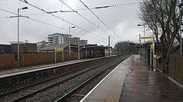 Prestwich Metrolink station in Jan 2017. | |||||||||||||||||||||||||||||||||||||||||||||||||||||||||||||||||||||||||||||||||||||||||||||||||||||||||||||
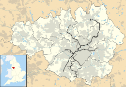 Prestwich Location of Prestwich in Greater Manchester | |||||||||||||||||||||||||||||||||||||||||||||||||||||||||||||||||||||||||||||||||||||||||||||||||||||||||||||
| Location | |||||||||||||||||||||||||||||||||||||||||||||||||||||||||||||||||||||||||||||||||||||||||||||||||||||||||||||
| Place | Prestwich | ||||||||||||||||||||||||||||||||||||||||||||||||||||||||||||||||||||||||||||||||||||||||||||||||||||||||||||
| Local authority | Bury | ||||||||||||||||||||||||||||||||||||||||||||||||||||||||||||||||||||||||||||||||||||||||||||||||||||||||||||
| Coordinates | 53°32′00″N 2°16′56″W / 53.5334°N 2.2823°WCoordinates: 53°32′00″N 2°16′56″W / 53.5334°N 2.2823°W | ||||||||||||||||||||||||||||||||||||||||||||||||||||||||||||||||||||||||||||||||||||||||||||||||||||||||||||
| Grid reference | SD814041 | ||||||||||||||||||||||||||||||||||||||||||||||||||||||||||||||||||||||||||||||||||||||||||||||||||||||||||||
| Platforms | 2 | ||||||||||||||||||||||||||||||||||||||||||||||||||||||||||||||||||||||||||||||||||||||||||||||||||||||||||||
| Fare zone information | |||||||||||||||||||||||||||||||||||||||||||||||||||||||||||||||||||||||||||||||||||||||||||||||||||||||||||||
| Metrolink Zone | B | ||||||||||||||||||||||||||||||||||||||||||||||||||||||||||||||||||||||||||||||||||||||||||||||||||||||||||||
| Present status | In operation | ||||||||||||||||||||||||||||||||||||||||||||||||||||||||||||||||||||||||||||||||||||||||||||||||||||||||||||
| Operations | |||||||||||||||||||||||||||||||||||||||||||||||||||||||||||||||||||||||||||||||||||||||||||||||||||||||||||||
| Original operator | Lancashire and Yorkshire Railway | ||||||||||||||||||||||||||||||||||||||||||||||||||||||||||||||||||||||||||||||||||||||||||||||||||||||||||||
| Pre-grouping company | Lancashire and Yorkshire Railway | ||||||||||||||||||||||||||||||||||||||||||||||||||||||||||||||||||||||||||||||||||||||||||||||||||||||||||||
| Post-grouping company |
London, Midland and Scottish Railway British Rail | ||||||||||||||||||||||||||||||||||||||||||||||||||||||||||||||||||||||||||||||||||||||||||||||||||||||||||||
| History | |||||||||||||||||||||||||||||||||||||||||||||||||||||||||||||||||||||||||||||||||||||||||||||||||||||||||||||
| Opened | 1 September 1879 | ||||||||||||||||||||||||||||||||||||||||||||||||||||||||||||||||||||||||||||||||||||||||||||||||||||||||||||
| Closed as rail station | 17 August 1991 | ||||||||||||||||||||||||||||||||||||||||||||||||||||||||||||||||||||||||||||||||||||||||||||||||||||||||||||
| Conversion to Metrolink operation | 6 April 1992 | ||||||||||||||||||||||||||||||||||||||||||||||||||||||||||||||||||||||||||||||||||||||||||||||||||||||||||||
| |||||||||||||||||||||||||||||||||||||||||||||||||||||||||||||||||||||||||||||||||||||||||||||||||||||||||||||
|
| |||||||||||||||||||||||||||||||||||||||||||||||||||||||||||||||||||||||||||||||||||||||||||||||||||||||||||||
Prestwich tram stop is a stop on the Bury Line of Greater Manchester's light rail Metrolink system. It is located at Prestwich, a town within the Metropolitan Borough of Bury, England.
The stop was originally Prestwich railway station, which was along the Manchester to Bury heavy rail line, completed by the Lancashire & Yorkshire Railway, in 1879 and opened on 1 September. The line was converted from steam to electric power as from 17 April 1916, using the third rail system. The station closed on 17 August 1991 to allow conversion of the route to the Metrolink system using overhead power lines, reopening on 6 April 1992.
The station forms part of Ticketing Zone B. It is located off Rectory Lane a walkway connects the station to the Longfield Suite Precinct and Bury New Road (A56).
Services
Services mostly run every 12 minutes on 2 routes, forming a 6-minute service between Bury and Manchester at peak times.
| Preceding station | Following station | |||
|---|---|---|---|---|
towards Altrincham | Altrincham – Bury Line | towards Bury |
||
towards Piccadilly | Bury – Piccadilly Line |
Connecting bus routes
Cumfybus service 484 runs to Eccles and Manchester Community Transport service 90 to the nearby Tesco stops outside the station.
On Bury New Road, which is on the opposite side of the shopping centre, First services 92, 93 and 98 run between Bury and Manchester (92 via Unsworth, Hollins and Pilsworth, 93 via Unsworth and 98 via Whitefield and Radcliffe), along with Maytree's 95 service between Bury and Pendleton and 495 service to Simister. Blackburn Bus Company services X40 and X41 between Manchester and Blackburn or Great Harwood via Accrington and Burnley Bus Company service X43 between Manchester and Nelson via Rawtenstall and Burnley also stop on Bury New Road.[1]
References
- ↑ "Network Maps". Transport for Greater Manchester. Archived from the original on 2 November 2012. Retrieved 10 September 2012.
External links
| Wikimedia Commons has media related to Prestwich Metrolink station. |
- Prestwich Stop Information
- Prestwich area map
- A Youtube video of Class 504s at Prestwich, before conversion into Metrolink.
- "The Directory of Railway Stations", R.V.J.Butt, 1995, Patrick Stephens, Sparkford UK, ISBN 1-85260-508-1
| Tram stops |
|   | ||||||||||||||||||
|---|---|---|---|---|---|---|---|---|---|---|---|---|---|---|---|---|---|---|---|---|
| Operations |
| |||||||||||||||||||
| History (Timeline) |
| |||||||||||||||||||
| Proposed developments |
| |||||||||||||||||||