Oldham King Street tram stop
| Oldham King Street | |
|---|---|
| Metrolink | |
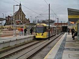 A tram at Oldham King Street tram stop in January 2014 | |
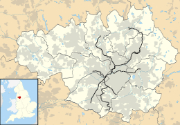 Oldham King Street Location of Oldham King Street in Greater Manchester | |
| Location | |
| Place | Oldham |
| Local authority | Oldham |
| Coordinates | 53°32′25″N 2°07′01″W / 53.5402°N 2.1169°WCoordinates: 53°32′25″N 2°07′01″W / 53.5402°N 2.1169°W |
| Grid reference | SD923048 |
| Platforms | 2 |
| Fare zone information | |
| Metrolink Zone | K |
| Present status | In operation |
| Operations | |
| Original operator | Manchester Metrolink |
| History | |
| Opened | 27 January 2014[1] |
|
| |
Oldham King Street is a tram stop on the Oldham and Rochdale Line (ORL) of Greater Manchester's light-rail Metrolink system and is located opposite Oldham Sixth Form College, at the junction of King Street and Union Street in Oldham, England. The stop opened on 27 January 2014. It is built on the site of the former King Street Baptist Church, which occupied the site from 1862 to 2005. The site was acquired by Compulsory Purchase Order in 2005, and the Church was rebuilt nearby in Chaucer Street with the compensation it received. A plaque, acknowledging this, on a stone pillar from the original church stands on the corner of the site.

Oldham King Street Metrolink station, under construction in February 2013
Service pattern
- 12 minute service to Shaw and Crompton with double trams in the peak
- 12 minute service to Rochdale Town Centre with double trams in the peak
- 6 minute service to East Didsbury with double trams in the peak
| Preceding station | Following station | |||
|---|---|---|---|---|
towards East Didsbury | East Didsbury – Rochdale Town Centre Line | towards Rochdale Town Centre |
References
- ↑ "> News > Date set for Oldham Metrolink line". Place North West. Retrieved 2014-02-02.
External links
| Wikimedia Commons has media related to Oldham King Street tram stop. |
| Tram stops |
|   | ||||||||||||||||||
|---|---|---|---|---|---|---|---|---|---|---|---|---|---|---|---|---|---|---|---|---|
| Operations |
| |||||||||||||||||||
| History (Timeline) |
| |||||||||||||||||||
| Proposed developments |
| |||||||||||||||||||
This article is issued from
Wikipedia.
The text is licensed under Creative Commons - Attribution - Sharealike.
Additional terms may apply for the media files.