Monsall tram stop
| Monsall | |
|---|---|
| Metrolink | |
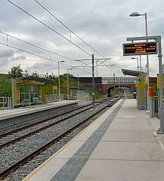 Monsall tram stop on its opening day | |
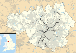 Monsall Location of Monsall in Greater Manchester | |
| Location | |
| Place | Monsall |
| Local authority | Manchester |
| Coordinates | 53°30′04″N 2°12′36″W / 53.5011°N 2.2101°WCoordinates: 53°30′04″N 2°12′36″W / 53.5011°N 2.2101°W |
| Platforms | 2 |
| Fare zone information | |
| Metrolink Zone | J |
| Present status | In operation |
| Operations | |
| Original operator | Metrolink |
| History | |
| Opened | 13 June 2012[1] |
|
| |
Monsall is a tram stop on the Oldham and Rochdale Line (ORL) of Greater Manchester's light-rail Metrolink system in the Monsall area of Manchester in North West England. It was built as part of Phase 3a of the system's expansion, on the route of the former Oldham Loop Line, and opened to passengers on 13 June 2012.[1]
The station is on the ex-Lancashire and Yorkshire Railway's Cheetham Hill Loop line between the former Thorpe's Bridge Junction (near Newton Heath TMD) and Irk Valley Junction, where the Oldham route joins the line from Bury en route to Victoria. The line through the station had previously been used by Manchester to Rochdale and Leeds services via the Caldervale Line to avoid the notorious Miles Platting incline and also by trains accessing the Red Bank carriage sidings until its closure in 1998 as part of the Manchester North re-signalling scheme.
Service pattern
- 12 minute service to Shaw and Crompton with double trams in the peak
- 12 minute service to Rochdale Town Centre with double trams in the peak
- 6 minute service to East Didsbury with double trams in the peak
| Preceding station | Following station | |||
|---|---|---|---|---|
towards East Didsbury | East Didsbury – Rochdale Town Centre Line | towards Rochdale Town Centre |
Connecting bus routes
Monsall station is served by First Greater Manchester/JPT services 88 and 89, which runs a circular route with buses running to Manchester Piccadilly Gardens or to Manchester Shudehill via White Moss, Higher Blackley and North Manchester General Hospital. Stagecoach Manchester service 80 also stops outside and runs westbound to Manchester and easbound to Middleton via Moston. The 151, operated by Stagecoach, stops nearby and runs between Hightown and Hollinwood.[2]
References
- 1 2 "Metrolink line to Oldham set to open". Transport for Greater Manchester. Retrieved 8 June 2012.
- ↑ "Transport for Greater Manchester - Journey Planning - Network Maps". Transport for Greater Manchester. Archived from the original on 2 November 2012. Retrieved 10 September 2012.
External links
| Wikimedia Commons has media related to Monsall Metrolink station. |
- https://web.archive.org/web/20120211143030/http://www.lrta.org/Manchester/Oldham_Rochdale.html
- Metrolink stop information
- Monsall area map
Manchester railways | |||||||||||||||||||||||||||||||||||||||||||||||||||||||||||||||||||||||||||||||||||||||||||||||||||||||||||||||||||||||||||||||||||||||||||||||||||||||||||||||||||||||||||||||||||||||||||||||||||||||||||||||||||||||||||||||||||||||||||||||||||||||||||||||||||||||||||||||||||||||||||||||||||||||||||||||||||||||||||||||||||||||||||||||||||||||||||||||||||||||||||||||||||||||||||||||||||||||||||||||||||||||||||||||||||||||||||||||||||||||||||||||||||||||||||||||||||||||||||||||||||||||||||||||||||||
|---|---|---|---|---|---|---|---|---|---|---|---|---|---|---|---|---|---|---|---|---|---|---|---|---|---|---|---|---|---|---|---|---|---|---|---|---|---|---|---|---|---|---|---|---|---|---|---|---|---|---|---|---|---|---|---|---|---|---|---|---|---|---|---|---|---|---|---|---|---|---|---|---|---|---|---|---|---|---|---|---|---|---|---|---|---|---|---|---|---|---|---|---|---|---|---|---|---|---|---|---|---|---|---|---|---|---|---|---|---|---|---|---|---|---|---|---|---|---|---|---|---|---|---|---|---|---|---|---|---|---|---|---|---|---|---|---|---|---|---|---|---|---|---|---|---|---|---|---|---|---|---|---|---|---|---|---|---|---|---|---|---|---|---|---|---|---|---|---|---|---|---|---|---|---|---|---|---|---|---|---|---|---|---|---|---|---|---|---|---|---|---|---|---|---|---|---|---|---|---|---|---|---|---|---|---|---|---|---|---|---|---|---|---|---|---|---|---|---|---|---|---|---|---|---|---|---|---|---|---|---|---|---|---|---|---|---|---|---|---|---|---|---|---|---|---|---|---|---|---|---|---|---|---|---|---|---|---|---|---|---|---|---|---|---|---|---|---|---|---|---|---|---|---|---|---|---|---|---|---|---|---|---|---|---|---|---|---|---|---|---|---|---|---|---|---|---|---|---|---|---|---|---|---|---|---|---|---|---|---|---|---|---|---|---|---|---|---|---|---|---|---|---|---|---|---|---|---|---|---|---|---|---|---|---|---|---|---|---|---|---|---|---|---|---|---|---|---|---|---|---|---|---|---|---|---|---|---|---|---|---|---|---|---|---|---|---|---|---|---|---|---|---|---|---|---|---|---|---|---|---|---|---|---|---|---|---|---|---|---|---|---|---|---|---|---|---|---|---|---|---|---|---|---|---|---|---|---|---|---|---|---|---|---|---|---|---|---|---|---|---|---|---|---|---|---|---|---|---|---|---|---|---|---|---|---|---|---|---|---|---|---|---|---|---|---|---|---|---|---|---|---|---|---|---|---|---|---|---|---|---|---|---|---|---|---|---|---|---|---|---|---|---|---|---|---|---|---|---|---|---|---|---|---|---|---|---|---|---|---|---|---|---|---|---|---|---|---|---|---|---|---|
City Centre and North Past, present and future | |||||||||||||||||||||||||||||||||||||||||||||||||||||||||||||||||||||||||||||||||||||||||||||||||||||||||||||||||||||||||||||||||||||||||||||||||||||||||||||||||||||||||||||||||||||||||||||||||||||||||||||||||||||||||||||||||||||||||||||||||||||||||||||||||||||||||||||||||||||||||||||||||||||||||||||||||||||||||||||||||||||||||||||||||||||||||||||||||||||||||||||||||||||||||||||||||||||||||||||||||||||||||||||||||||||||||||||||||||||||||||||||||||||||||||||||||||||||||||||||||||||||||||||||||||||
| |||||||||||||||||||||||||||||||||||||||||||||||||||||||||||||||||||||||||||||||||||||||||||||||||||||||||||||||||||||||||||||||||||||||||||||||||||||||||||||||||||||||||||||||||||||||||||||||||||||||||||||||||||||||||||||||||||||||||||||||||||||||||||||||||||||||||||||||||||||||||||||||||||||||||||||||||||||||||||||||||||||||||||||||||||||||||||||||||||||||||||||||||||||||||||||||||||||||||||||||||||||||||||||||||||||||||||||||||||||||||||||||||||||||||||||||||||||||||||||||||||||||||||||||||||||
| Tram stops |
|   | ||||||||||||||||||
|---|---|---|---|---|---|---|---|---|---|---|---|---|---|---|---|---|---|---|---|---|
| Operations |
| |||||||||||||||||||
| History (Timeline) |
| |||||||||||||||||||
| Proposed developments |
| |||||||||||||||||||