West Lakes, South Australia
| West Lakes South Australia | |||||||||||||||
|---|---|---|---|---|---|---|---|---|---|---|---|---|---|---|---|
 West Lakes | |||||||||||||||
| Coordinates | 34°52′22″S 138°29′43″E / 34.872650°S 138.495410°ECoordinates: 34°52′22″S 138°29′43″E / 34.872650°S 138.495410°E | ||||||||||||||
| Population | 5,730 (2011 census)[1] | ||||||||||||||
| Established | 1970s | ||||||||||||||
| Postcode(s) | 5021 | ||||||||||||||
| LGA(s) | City of Charles Sturt | ||||||||||||||
| State electorate(s) | Lee | ||||||||||||||
| Federal Division(s) | Hindmarsh | ||||||||||||||
| |||||||||||||||
| Footnotes |
Coordinates.[2] Adjoining suburbs[2] | ||||||||||||||
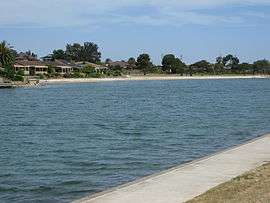
West Lakes is a suburb of Adelaide, the state capital of South Australia, Australia. It lies within the City of Charles Sturt. It contains the Westfield West Lakes Shopping Centre, AAMI Stadium and the Riverside Golf Course. It also contains Delfin Island, a residential island within Boating Lake.
West Lakes has an irregular shape and shares borders with Port Adelaide, Queenstown, Royal Park, Seaton, Grange, Tennyson and West Lakes Shore.
The counted population on the night of the 2001 census was 5,940, and in 2011 was recorded 5,730.[1]
History
West Lakes was constructed on a tidal swamp by property developer Delfin (now Lend Lease Communities) from reclaimed land during the early 1970s. Development earthworks commenced in September 1970 and West Lakes was officially opened on 18 March 1977 by the Hon Des Corcoran, MP, Deputy Premier and Minister of Marine. West Lakes Post Office opened on 27 August 1975.[3]
The suburb is home to Football Park (also known by its sponsored name of AAMI Stadium), a 51,240-seat sports stadium and home of the SANFL between 1974 and 2013.
References
- 1 2 Australian Bureau of Statistics (31 October 2012). "West Lakes". 2011 Census QuickStats. Retrieved 10 April 2013.

- 1 2 "Search result for "WEST LAKES (SUB)" (Record no SA0019442) with the following layers being selected - "Suburbs and Localities", "Local Government Areas", "Development Plan Layers", "Place names (gazetteer)" and "Counties"". Property Location Browser. Government of South Australia. Retrieved 2 May 2017.
- ↑ Premier Postal History. "Post Office List". Premier Postal Auctions. Retrieved 26 May 2011.
External links
- West Lakes — Summary of historical information relevant to the dispersal of sludge from the South Australian Environment Protection Authority (EPA).
- West Lakes: You'll want to live here. Promotional film includes footage of the area pre-development, then South Australian Premier Don Dunstan and Deputy Premier Des Corcoran, aerial views of the land and coastal development, creation of the central lake, Football Park and the finished suburb. South Australian Film Corporation, Adelaide, 1974.