Port Egmont
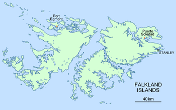
Port Egmont (Spanish: Puerto de la Cruzada; French: Poil de la Croisade) was the first British settlement in the Falkland Islands, on Saunders Island and is named after the Earl of Egmont.
History


Port Egmont was established in on 25 January 1765, by an expedition led by Commodore John Byron consisting of the boats HMS Dolphin, HMS Tamar and HMS Florida. The expedition left a watering place and a vegetable garden.
Another expedition arrived around a year later in January 1766, led by Captain John MacBride, with the ships HMS Jason, HMS Carcass and HMS Experiment after which Carcass Island and the Jason Islands are named. This was to secure possession, and McBride ordered one of the ships to stay at Port Egmont, and develop the settlement, resulting in several permanent buildings and a garrison. MacBride, in command of HMS Jason, carried out the first hydrographic survey of the Falklands in 1766 and discovered a number of minor islands including Weddell, Beaver and New Islands off the southwest extremity of the archipelago. The chart based on that survey[2] was one of the most accurate for its time.[3][4] MacBride also made the first systematic meteorological observations in the Falklands. In January and February the thermometer at Port Egmont rose to 59 °F (15 °C), but no higher; in August, it once fell to 20 °F (−7 °C), but was seldom lower than 32 °F (0 °C).[5]
The next few years resulted in conflicting claims with the French and Spanish, with the British using Port Egmont as a basis for their claim. In early 1770 Spanish commander Don Juan Ignacio de Madariaga briefly visited Port Egmont. He returned from Argentina on 10 June with five armed ships and a 1400 soldiers forcing the British to leave Port Egmont.
In 1771, after threats of war with Spain, the colony was re-established by Captain John Stott with the ships HMS Juno, HMS Hound and HMS Florida, the latter being at the founding of the original settlement. The port became an important stop for ships going around Cape Horn
In 1774, Britain abandoned many of its overseas garrisons for economic reasons and Port Egmont was no exception, and in 1776, the British forces left. In the next few years, the colony was taken over by sealers, until in 1780 it was finally destroyed under orders from Spanish authorities.
See also
- Port Saint Louis, the first settlement on the islands (by French colonists)
Notes
- ↑ D. Andrew. Malaspina, Alejandro. In: Dictionary of Falklands Biography including South Georgia. Ed. David Tatham. London, 2008. 576 pp.
- ↑ J. MacBride. A chart of Hawkins’s Maidenland, discovered by Sr. Richard Hawkins in 1574 and Falkland Sound, so called by Capn. John Strong of the Farewell from London who sailed through it in 1689. Scale 1:1000000. In: An account of the voyages undertaken by the order of His present Majesty for making discoveries in the Southern Hemisphere. Eds. J. Hawkesworth and J. Byron. Vol. I. London: W. Strahan and T. Cadell, 1773 (following p. 40)
- ↑ The Malaspina Expedition 1789–1794. The Journal of the Voyage by Alejandro Malaspina. Vol. I. Cadiz to Panama. Eds. A. David, F. Fernandez-Armesto, C. Novi and G. Williams. London: Hakluyt Society, 2001. 436 pp. (The Spanish navigator Alejandro Malaspina wrote in 1789: ... we found Captain MacBride’s chart very accurate, while the chart we acquired in Montevideo, even though recommended as the best one of this area, was most inaccurate, at least for this part of the coast.)
- ↑ R. Lorton. Falklands Wars – the History of the Falkland Islands with particular regard to Spanish and Argentine pretensions and taking some account of South Georgia, the South Sandwich Islands and Britain’s Antarctic territories. 2017. p. 115
- ↑ J. MacBride. Journal of the Winds and Weather and Degrees of Heat and Cold by the Thermometer, at Falkland Islands, from 1st February 1766 to 19th January 1767. In: A. Dalrymple. A Collection of Voyages, Chiefly in the Southern Atlantick Ocean. London, 1775. 198 pp.
External links
| Wikimedia Commons has media related to Port Egmont. |
Coordinates: 51°21′13.44″S 60°3′50.57″W / 51.3537333°S 60.0640472°W