Cape Juby
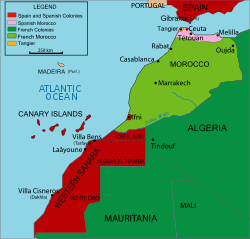
Cape Juby (Arabic: رأس جوبي, trans. Raʾs Juby, Spanish: Cabo Juby) is a cape on the coast of southern Morocco, near the border with Western Sahara, directly east of the Canary Islands.
Its surrounding area, called Cape Juby Strip or Tarfaya Strip, while making up presently the far South of Morocco, is in a way a semi-desertic buffer zone between Morocco proper and the Western Sahara, and was under Spanish rule as the southern part of the Spanish protectorate in Morocco in the first half of the 20th century.
Modern history
Precolonial era
On May 28, 1767, Mohammed ben Abdallah, the Sultan of Morocco, signed a peace and commerce treaty with King Charles III of Spain. In the treaty, Morocco did not guarantee the security of Spanish fishermen in the coasts south of the Noun River, as Morocco did not have control over the Tekna tribes of that area (Art. 18). [1] [2]
On March 1, 1799, Sultan Slimane of Morocco signed an accord with King Charles IV of Spain, in which he recognized that the Saguia el Hamra and Cape Juby regions were not part of his dominions (Art. 22).[1][2]
In 1879, the British North West Africa Company established a trading post near Cape Juby called "Port Victoria". On March 26, 1888, Moroccan soldiers attacked the post, killing the director of the post and leaving two workers badly injured.[3] In 1895, the company sold its post to the Sultan of Morocco.
Spanish protectorate
In 1912, Spain negotiated with France (which controlled the affairs of Morocco at the time) for concessions on the southern edge of Morocco. Francisco Bens officially occupied the Cape Juby region for Spain on July 29, 1916. It was administered by Spain as a single entity with Spanish Sahara and Ifni, as Spanish West Africa.
The Spanish area 12,700 sq mi (33,000 km2), and had a population of 9,836. Its main town was founded by the Spanish as Villa Bens (now called Tarfaya). Villa Bens was used as a staging post for airmail flights.
Retrocession to Morocco
When Morocco became independent in 1956, it asked for the cession of Moroccan areas controlled by Spain. After some resistance and some fighting during 1957 (the Ifni War), the Spanish government in 1958 ceded the Cape Juby strip to Morocco.
Sahara sea
In 1877 the Scottish engineer Donald Mackenzie was the first to propose the creation of a Sahara Sea. Mackenzie's idea was to cut a channel from one of the sand-barred lagoons north of Cape Juby south to a large plain which Arab traders had identified to him as El Djouf.[4][5] Mackenzie believed this vast region was up to 61 metres (200 ft) below sea level and that flooding it would create an inland sea of 155,400 square kilometres (60,000 sq mi) suited to commercial navigation and even agriculture. He further believed that geological evidence suggested this basin had once been connected to the Atlantic via a channel near the Saguia el-Hamra. He proposed that this inland sea, if augmented with a canal, could provide access to the Niger River and the markets and rich resources of West Africa.[5] There are several small depressions in the vicinity of Cape Juby; at 55 m below sea level, the Sebkha Tah[6] is the lowest and largest. But it covers less than 250 km² and is 500 km north of the geographical area identified as El Djouf (also known as the Majabat al-Koubra[7]) which has an average elevation of 320 m. Mackenzie never travelled in this area but had read of other sub-sea level desert basins in present-day Tunisia, Algeria and Egypt similar to those found near Cape Juby.[5] These basins contain seasonally dry salt lakes, known as chotts or sebkhas. Egypt's Qattara Depression is perhaps the largest such basin in North Africa.
See also
References
- 1 2 Pedro Giménez de Aragón Sierra. "Proyecto Ibn Jaldun. VII. El colonialismo español en el s. XIX: África. 2. Chafarinas, Sidi Ifni y el Sáhara" (in Spanish). Junta de Andalucía. Retrieved 2010-06-15.
- 1 2 Cesáreo Fernández Duro (08-09-1877). "Cautivos españoles en Cabo Blanco" (PDF) (in Spanish). La Ilustración Española y Americana nº XXXIII. p. 156. Retrieved 2010-06-16. Check date values in:
|date=(help) - ↑ José Fernández Bromón (1888-05-15). "Sucesos de Marruecos" (PDF) (in Spanish). La Ilustración Española y Americana nº XVIII. p. 307. Retrieved 2010-07-23.
- ↑ Cust, R. (1884). "The railway over the Sahára from Algeria to the Senegál and the destruction of Colonel Flatters". Journal of the Royal United Service Institution. Royal United Services Institute for Defence Studies. 28 (77): 839–856. doi:10.1080/03071848409424351. Retrieved 18 December 2012.
- 1 2 3 Mackenzie, Donald (1877). The flooding of the Sahara: an account of the proposed plan for opening Central Africa to commerce and civilization from the north-west coast, with a description of Soudan and western Sahara, and notes of ancient manuscripts, &c. London: Sampson Low, Marston, Searle, & Rivington. Retrieved 18 December 2012.
- ↑ fr:Sebkha Tah
- ↑ "El Djouf desert, Mauritania". mr.geoview.info.
Coordinates: 27°56′52″N 12°55′24″W / 27.94778°N 12.92333°W