Ifni
| Ifni | |||||
| Province of Spain | |||||
| |||||
 | |||||
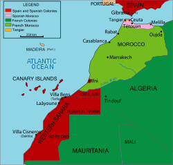 central red area (click to enlarge). | |||||
| Capital | Sidi Ifni | ||||
| Governor-General | |||||
| • | 1958–1961 (first) | Mariano Gómez Zamalloa y Quirce | |||
| • | 1969 (last) | José Rodríguez | |||
| History | |||||
| • | Established | 12 January 1958 | |||
| • | Returned to Morocco | 4 January 1969 | |||
| Area | |||||
| • | 1969 | 1,502 km2 (580 sq mi) | |||
| Population | |||||
| • | 1964 | 51,517 | |||

Ifni was a Spanish province on the Atlantic coast of Morocco, south of Agadir and across from the Canary Islands.
It had a total area of 1,502 km² (580 sq mi), and a population of 51,517 in 1964. The main industry was fishing.
History
Spain's presence in the area can be traced to a settlement called Santa Cruz de la Mar Pequeña, founded in 1476. After attacks by the Berbers, the Spanish decided to focus on colonising other areas of North Africa and abandoned the region.
In the mid-19th century, when the European powers looked again to Africa for resources, Spain suddenly mooted an interest in its lost late medieval fortress in order to stake a claim to the southern part of Morocco. This served as a pretext for a short war with Morocco in 1859.
The territory and its main town of Sidi Ifni were ceded to Spain by the Sultanate of Morocco on 26 April 1860, but there was little interest in this colonial acquisition until 1934, when the Governor-General of Spanish Sahara took up residence.
Until 1952, Ifni region had the status of a protectorate. In this year, the region became part of Spanish West Africa (entity that grouped the colonies of Spanish Sahara and Cape Juby).
After the Ifni War (1957), most of the territory became occupied de facto by Morocco. In 1958, the colony was made into a Spanish province in order to forestall United Nations criticism of continued colonisation.
Spain formally returned the territory to Morocco on 30 June 1969.[1] The territory was integrated into the Moroccan region of Souss-Massa-Drâa.
Postage stamps
Spain began issuing postage stamps for Ifni in 1941, initially overprinting Spanish stamps with "TERRITORIO DE IFNI", then issuing new designs in 1943. Issues followed at the rate of about ten per year with the last on 23 November 1968. Most are commonly available and are more often seen unused than used.
See also
References
- ↑ United Nations Yearbook 1969, pp. 661-64.
External links
- (in Spanish) Ifni Friend's Association (Asociación de Amigos de Ifni)
- (in Spanish) Ifni stamp gallery
- (in Spanish) The Corner of Sidi Ifni (El Rincón de Sidi Ifni)
- (in Spanish) Ifni today (Links for traveling to Ifni)
- (in Spanish) Jomabase photo album on Picasa
- (in German) Maps of Ifni