Mount Kent
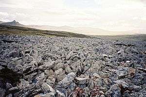
Stone run at Mount Kent, East Falkland
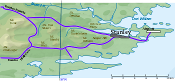
Position of Mount Kent relative to other surrounding hills
Mount Kent is a mountain on East Falkland, Falkland Islands,[1] It is north of Mount Challenger and saw action in the Falklands War during the Battle of Mount Harriet – some of the area is still mined.
Murrell River rises on Mount Challenger, but tributaries coming off Mount Kent, Harriet and Two Sisters... it could be seen as part of the catchment area.
Mount Kent also has an impressive stone run – see picture.
The mountain's top is occupied by the RRH Mount Kent (Remote Radar Head Mount Kent) of the British Forces South Atlantic Islands (BFSAI),[2] part of an early warning and airspace control network including also RRH Mount Alice and RRH Byron Heights on West Falkland.
References
- ↑ Strange, Ian (1983) The Falkland Islands
- ↑ Post Conflict and RAF Stanley. Think Defence Website, 2017
This article is issued from
Wikipedia.
The text is licensed under Creative Commons - Attribution - Sharealike.
Additional terms may apply for the media files.