Cape Pembroke
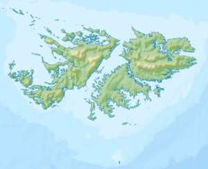
Cape Pembroke (Spanish: Cabo San Felipe)[1] is the easternmost point of the Falkland Islands, and is on East Falkland. There is an automated lighthouse here.
Lighthouse
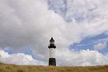 Cape Pembroke Lighthouse | |
 Cape Pembroke Lighthouse Falkland Islands | |
| Location |
Cape Pembroke Falkland Islands |
|---|---|
| Coordinates | 51°40′55″S 57°43′13″W / 51.681834°S 57.720400°W |
| Year first constructed | 1855 (first) |
| Year first lit | 1987 (current) |
| Deactivated | 1982 (first) |
| Construction | cast iron tower |
| Tower shape | cylindrical tower with balcony and lantern |
| Markings / pattern | black tower with a horizontal white band, black lantern |
| Height | 18 metres (59 ft) (first) |
| Focal height | 30 metres (98 ft) (current) |
| Original lens | 3rd order Fresnel lens |
| Range | 10 nautical miles (19 km; 12 mi) |
| Characteristic | Fl (3) W 20s. |
| Admiralty number | G1352 |
| NGA number | 20336 |
| ARLHS number | FAL-001 |
| Managing agent | Falkland Islands Museum and National Trust[2] |
An automated 18 metres (59 ft) lighthouse on Cape Pembroke was built in 1855, and rebuilt in 1906, and was restored in the 1990s. Previously, the nearby Billy Rock offshore had claimed fifteen ships, and there were unlit markers here.
The original light used rape seed oil, but as it burnt a thousand gallons a year, sea lion oil was attempted as a substitute. When it was rebuilt in 1906, it was converted to paraffin and worked by clockwork. After World War II a less romantic structure was built to the east.
A small lighthouse keepers cottage used to stand here. The lighthouse itself, is now a listed building.[3]
Farm and James Smith
In the late nineteenth century, Cape Pembroke peninsula was a small farm, which the islands' government leased to James Smith of Stanley. There were few such small farms in the islands and James Smith was ardent in his support of agrarian reform.
References
- ↑ "Archived copy" (PDF). Archived from the original (PDF) on 2012-10-22. Retrieved 2014-07-18.
- ↑ Rowlett, Russ. "Lighthouses of Falkland Islands". The Lighthouse Directory. University of North Carolina at Chapel Hill. Retrieved January 17, 2016.
- ↑ "Falkland Islands Information Web Portal". Buildings and Structures in the Falkland Islands designated as being of Architectural or Historic Interest. Archived from the original on 2012-07-28. Retrieved 2008-07-08.
| Wikimedia Commons has media related to Pembroke Lighthouse. |