Felipe González de Ahedo
Felipe González de Ahedo, also spelled Phelipe González y Haedo (13 May 1714 in Santoña, Cantabria – 26 October 1802), was a Spanish navigator and cartographer known for annexing Easter Island in 1770.
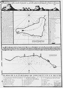
González de Ahedo commanded two Spanish ships, the San Lorenzo and the Santa Rosalia, sent by the Viceroy of Peru, Manuel de Amat y Juniet. They landed on 1770 November 15, only the second time European had seen Easter Island, and stayed five days, thoroughly surveyed the coast, and named it Isla de San Carlos, taking possession on behalf of King Charles III of Spain. They ceremoniously signed a treaty of annexation with the inhabitants and erected three wooden crosses on top of three small hills on Poike volcano.[1]
They were amazed by the "standing idols", moai, all of which they could see were erect.[2]
References
| Authority control |
|---|