Port-aux-Français
| Port-aux-Français | |
|---|---|
| Village | |
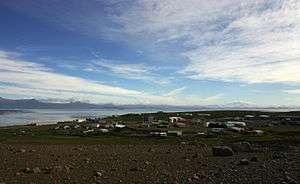 Port-aux-Français in 2004 | |
|
Port-aux-Français Location in Kerguelen Islands & Indian Ocean 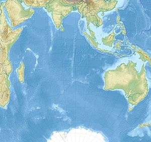 Port-aux-Français Port-aux-Français (Indian Ocean) | |
| Coordinates: 49°20′55″S 70°13′09″E / 49.348653°S 70.219305°ECoordinates: 49°20′55″S 70°13′09″E / 49.348653°S 70.219305°E | |
| Country | France |
| Territory | French Southern and Antarctic Lands (TAAF) |
| District | Kerguelen Islands |
Port-aux-Français is the capital settlement of the Kerguelen Islands, French Southern and Antarctic Lands, in the south Indian Ocean. The port station is located on the Gulf of Morbihan, at 49°21′00″S 70°13′08″E / 49.35°S 70.219°E.
Research station
The station was selected in 1949 by the chief of mission Pierre Sicaud because of its sheltered position which was suitable for a runway that was never built. From 1955 to 1957, and using Australian equipment, a French slaughterhouse company called Sidap constructed a sealing factory. The factory opened following the first marriage on the islands, that of Marc Pechenart and Martine Raulin on 16 December 1957. The factory closed in 1960, and the equipment was sent to Réunion in 2005. It has about 45 inhabitants in winter; the population can rise to more than 120 in summer.
Port-aux-Français has a shallow seaport and a quay for unloading supply ships, including the Marion Dufresne. The station, in addition to logistics necessary to its operation, consists of scientific laboratories (biology, geophysics), technical installations (meteorology, telecommunications, satellite tracking, et cetera), a cinema and a small medical centre.
Tidal gauges
The base of Port-aux-Français is equipped with a recently installed marigraphic station, having 3 measuring devices:
- two tide gauges to measure pressure at sea bottom
- a radar measuring the sea level.
The two marigraphs and the radar send data to a local server, which relays them hourly to the Internet via the Argos satellite system.
Climate
Port-aux-Français has an ocean moderated mild tundra climate (Köppen climate classification ET).[1] Temperatures (without windchill) tend to remain fairly stable throughout the year, rarely reaching over 18 °C (64 °F) or falling below −8 °C (18 °F).[2] The average temperature in February, the warmest month, is 7.5 °C (45.5 °F) with a maximum of 11.5 °C (52.7 °F) during the day and 4.3 °C (39.7 °F) during the night. In winter, August and July are the coldest months, averaging 4.8 to 5.0 °C (40.6 to 41.0 °F) during the day and −0.8 °C (30.6 °F) at night.
Snowfall is possible in all months, even in summer though it is more common during the winter months than during the summer months. The climate is windier than in most places, with a recorded gust of 80 m/s (290 km/h; 180 mph).[3] The lowest recorded temperature was −9.5 °C (14.9 °F) on 11 August 2014, which beats the old record of −9.4 °C (15.1 °F) set in June 1953.[4] The highest temperature was 23.0 °C (73.4 °F) on 30 January 1959.[5]
| Climate data for Port-aux-Français, Kerguelen Islands (1981–2010 averages, extremes 1950–present) | |||||||||||||
|---|---|---|---|---|---|---|---|---|---|---|---|---|---|
| Month | Jan | Feb | Mar | Apr | May | Jun | Jul | Aug | Sep | Oct | Nov | Dec | Year |
| Record high °C (°F) | 25.8 (78.4) |
23.6 (74.5) |
22.3 (72.1) |
23.1 (73.6) |
16.8 (62.2) |
14.5 (58.1) |
13.2 (55.8) |
15.0 (59) |
15.8 (60.4) |
19.1 (66.4) |
19.9 (67.8) |
22.1 (71.8) |
25.8 (78.4) |
| Average high °C (°F) | 11.9 (53.4) |
12.2 (54) |
11.1 (52) |
9.4 (48.9) |
7.1 (44.8) |
5.4 (41.7) |
5.1 (41.2) |
5.2 (41.4) |
5.8 (42.4) |
7.4 (45.3) |
9.1 (48.4) |
10.9 (51.6) |
8.4 (47.1) |
| Daily mean °C (°F) | 8.2 (46.8) |
8.4 (47.1) |
7.6 (45.7) |
6.1 (43) |
4.1 (39.4) |
2.7 (36.9) |
2.3 (36.1) |
2.3 (36.1) |
2.8 (37) |
4.0 (39.2) |
5.5 (41.9) |
7.2 (45) |
5.1 (41.2) |
| Average low °C (°F) | 4.5 (40.1) |
4.7 (40.5) |
4.0 (39.2) |
2.9 (37.2) |
1.1 (34) |
0.0 (32) |
−0.5 (31.1) |
−0.5 (31.1) |
−0.3 (31.5) |
0.7 (33.3) |
1.9 (35.4) |
3.5 (38.3) |
1.8 (35.2) |
| Record low °C (°F) | −1.5 (29.3) |
−1.0 (30.2) |
−1.8 (28.8) |
−4.4 (24.1) |
−7.2 (19) |
−8.5 (16.7) |
−8.9 (16) |
−9.5 (14.9) |
−7.6 (18.3) |
−5.1 (22.8) |
−4.4 (24.1) |
−3.3 (26.1) |
−9.5 (14.9) |
| Average precipitation mm (inches) | 51.1 (2.012) |
43.8 (1.724) |
64.9 (2.555) |
57.9 (2.28) |
67.3 (2.65) |
64.7 (2.547) |
64.0 (2.52) |
58.9 (2.319) |
54.1 (2.13) |
45.3 (1.783) |
49.4 (1.945) |
55.8 (2.197) |
677.2 (26.661) |
| Average precipitation days (≥ 1.0 mm) | 8.4 | 6.7 | 9.3 | 9.1 | 10.8 | 10.2 | 11.1 | 9.7 | 9.1 | 7.8 | 7.9 | 9.3 | 109.5 |
| Average snowy days | 1 | 0 | 2 | 4 | 6 | 10 | 11 | 13 | 12 | 11 | 7 | 2 | 79 |
| Mean monthly sunshine hours | 190.0 | 162.5 | 143.0 | 110.9 | 93.2 | 70.2 | 83.6 | 105.1 | 125.8 | 153.6 | 175.1 | 189.0 | 1,601.8 |
| Source #1: Météo France[6] | |||||||||||||
| Source #2: Weatherbase (snow days)[2] | |||||||||||||
See also
References
- ↑ Peel, M. C. and Finlayson, B. L. and McMahon, T. A. (2007). "Updated world map of the Köppen–Geiger climate classification" (PDF). Hydrol. Earth Syst. Sci. 11: 1633–1644. doi:10.5194/hess-11-1633-2007. ISSN 1027-5606.
- 1 2 "Weatherbase: Historical Weather for Port Aux Francais, France". Weatherbase. Retrieved February 28, 2013.
- ↑ "Climate Normals for Port Aux Francais 1961-1990". National Oceanic and Atmospheric Administration. Retrieved February 28, 2013.
- ↑ http://www.ogimet.com/cgi-bin/gsynres?ind=61998&decoded=yes&ndays=2&ano=2014&mes=08&day=12&hora=00
- ↑ http://docs.lib.noaa.gov/rescue/cd008A_pdf/0025873d.pdf
- ↑ "Kerguelen (984)" (PDF). Fiche Climatologique: Statistiques 1981–2010 et records (in French). Meteo France. Archived from the original (PDF) on 27 February 2018. Retrieved 26 February 2018.
| Wikimedia Commons has media related to Port-aux-Français Station. |
| General |
| .svg.png) |
|---|---|---|
| Geographic regions | ||
| Waterways | ||
| Famous explorers | ||