French Southern and Antarctic Lands
| French Southern and Antarctic Lands Terres australes et antarctiques françaises (TAAF) | |
|---|---|
 Coat of arms
| |
|
Motto: "Liberté, Égalité, Fraternité" | |
|
Anthem: "La Marseillaise" | |
_(Madagascar_centered).svg.png) Location of French Southern and Antarctic Lands (circled in red) in the Indian Ocean (light blue) | |
| Capital | Saint-Pierre on Réunion Island |
| Official languages | French |
| Government | |
| Emmanuel Macron | |
• Préfet | Cécile Pozzo di Borgo |
| Territoire d'outre-mer | |
• Date | 1955 |
| Area | |
• Total | 439,781 km2 (169,800 sq mi) |
| Population | |
• Census | 0 |
| Currency | Euro (EUR) |
| ISO 3166 code | TF |
| Internet TLD | .tf |
|
Flag of the French Southern and Antarctic Lands: see CIA World Factbook | |
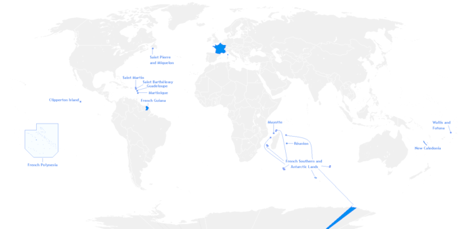
The French Southern and Antarctic Lands[1] (French: Terres australes et antarctiques françaises, TAAF) is an overseas territory (French: Territoire d'outre-mer or TOM) of France. It consists of:
- Kerguelen Islands (Archipel des Kerguelen), a group of volcanic islands in the southern Indian Ocean, southeast of Africa, approximately equidistant between Africa, Antarctica and Australia;
- St. Paul and Amsterdam islands (Îles Saint Paul et Amsterdam), a group to the north of Kerguelen;
- Crozet Islands (Îles Crozet), a group in the southern Indian Ocean, south of Madagascar;
- Adélie Land (Terre Adélie), the French claim on the continent of Antarctica;
- the Scattered Islands (Îles Éparses), a dispersed group of islands around the coast of Madagascar.
The territory is sometimes referred to as the French Southern Lands (French: Terres australes françaises) or French Southern Territories, usually to emphasize non-recognition of French sovereignty over Adélie Land as part of the Antarctic Treaty system.
The territory has no permanent civilian population.[2] Those resident consist of visiting military personnel, officials, scientific researchers and support staff.
Administration
The French Southern and Antarctic Lands have formed a territoire d'outre-mer (an overseas territory) of France since 1955. Formerly, they were administered from Paris by an administrateur supérieur assisted by a secretary-general; since December 2004, however, their administrator has been a préfet, currently Cécile Pozzo di Borgo, with headquarters in Saint-Pierre on Réunion Island.
The territory is divided into five districts:
| District | Capital | Population | Area | EEZ | |
|---|---|---|---|---|---|
| Winter | Summer | (km2) | |||
| Saint Paul / Île Amsterdam | Martin-de-Viviès | 25 | 45 | 61 | 502,533 |
| Archipel Crozet | Alfred Faure | 25 | 45 | 352 | 567,475 |
| Archipel des Kerguelen | Port-aux-Français | 70 | 110 | 7,215 | 563,869 |
| Terre Adélie | Dumont d'Urville Station | 30 | 110 | 432,000 | — |
| Îles Éparsesa | Saint-Pierreb | 56 | 56 | 38.6 | 593,276 |
| TAAF | Saint-Pierrec | 150 | 310 | 439,781 | 2,274,277 |
a According to new law 2007-224 of February 21, 2007, the Scattered Islands constitute the TAAF's fifth district.[3] The TAAF website does not mention their population. The data are not included in the totals.
b The Îles Éparses principal station is on Tromelin Island. The headquarters of the district chief lies beyond the TAAF, in Saint-Pierre on Réunion Island.
c The Territory's principal station is Martin-de-Viviès on Île Amsterdam. The capital and headquarters of the Territorial administrator lies beyond the TAAF, in Saint-Pierre on Réunion Island.
Each district is headed by a district chief, who has powers similar to those of a French mayor (including recording births and deaths and being an officer of judicial police).
Because there is no permanent population, there is no elected assembly, nor does the territory send representatives to the national parliament.
Districts as per new proposal
These are the districts per new proposal:
Geography
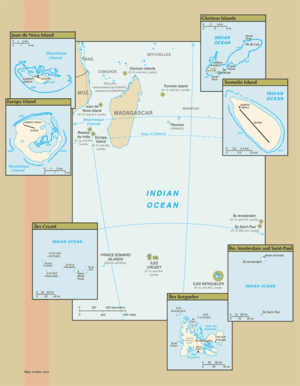
Adélie Land (in Antarctica) and Banc du Geyser and Bassas da India (in the Îles Éparses district) are not shown.
The territory includes Amsterdam Island, Saint-Paul Island, Crozet Islands, and the Kerguelen Islands in the southern Indian Ocean near 43°S, 67°E, along with Adélie Land, the sector of Antarctica claimed by France, named by the French explorer Jules Dumont d'Urville after his wife.
Adélie Land (about 432,000 km2 or 167,000 sq mi) and the islands, totaling 7,781 km2 (3,004 sq mi), have no indigenous inhabitants, though in 1997 there were about 100 researchers whose numbers varied from winter (July) to summer (January).
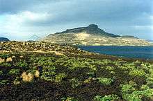
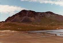
Amsterdam Island and Saint-Paul Island are extinct volcanoes and have been delineated as the Amsterdam and Saint-Paul Islands temperate grasslands ecoregion. The highest point in the territory is Mont Ross on Kerguelen Island at 1,850 m (6,070 ft). There are very few airstrips on the islands, only existing on islands with weather stations, and the 1,232 km (766 mi) of coastline have no ports or harbors, only offshore anchorages.
The islands in the Indian Ocean are supplied by the special ship Marion Dufresne sailing out of Le Port in Réunion Island. Terre Adélie is supplied by Astrolabe sailing out of Hobart in Tasmania.
However, the territory has a merchant marine fleet totaling (in 1999) 2,892,911 GRT/5,165,713 tonnes deadweight (DWT), including seven bulk carriers, five cargo ships, ten chemical tankers, nine container ships, six liquefied gas carriers, 24 petroleum tankers, one refrigerated cargo ship, and ten roll-on-roll-off (RORO) carriers. This fleet is maintained as a subset of the French register that allows French-owned ships to operate under more liberal taxation and manning regulations than permissible under the main French register. This register, however, is to vanish, replaced by the International French Register (Registre International Français, RIF).
The territory contains the only land mass that is antipodal to the Contiguous United States. The far northern tip of the Kerguelen Islands, near Baie de l'Oiseau (48°40′09″S 69°01′23″E / 48.669199°S 69.02298°E), is directly opposite the globe to the small area north of US Highway 2 between Chester, Montana, and Rudyard, Montana, and south of the Canada–US border. Amsterdam Island and Saint-Paul Island lie antipodal to two small areas in south-eastern Colorado, near the cities of Lamar and Cheyenne Wells, respectively.[4]
Flora and fauna
| Designations | |
|---|---|
| Official name | Réserve Naturelle Nationale des Terres Australes Francaises |
| Designated | 15 September 2008 |
| Reference no. | 1837[5] |
Economy
The territory's natural resources are limited to fish and crustaceans. Economic activity is limited to servicing meteorological and geophysical research stations and French and other fishing fleets.
The main fish resources are Patagonian toothfish and spiny lobster. Both are poached by foreign fleets; because of this, the French Navy and occasionally other services patrol the zone and arrest poaching vessels. Such arrests can result in heavy fines and/or the seizure of the ship.
France used to sell licenses to foreign fisheries to fish the Patagonian toothfish; because of overfishing, it is now restricted to a small number of fisheries from Réunion Island.
The territory takes in revenues of about €16 million a year.
Codes
The French Southern Territories (i.e. the TAAF excluding Adélie Land) have been given the following country codes: FS (FIPS) and TF (ISO 3166-1 alpha-2).
See also
References
- ↑ "List of countries, territories and currencies". Interinstitutional style guide. Publications Office. 2008-06-12. Retrieved 2008-06-29.
- ↑ "The TAAF do not have any permanent population." "The French Southern and Antarctic Lands". French Southern and Antarctic Lands administration. Retrieved 31 May 2016.
- ↑ "Les îles Éparses". Archived from the original on May 2, 2007. Retrieved 2007-03-03.
- ↑ "Colorado land antipodes". Usends.com. 2010-12-22. Archived from the original on 2013-10-21. Retrieved 2013-10-21.
- ↑ "Réserve Naturelle Nationale des Terres Australes Francaises". Ramsar Sites Information Service. Retrieved 25 April 2018.
External links
| Wikimedia Commons has media related to French Southern and Antarctic Lands. |
| Wikivoyage has a travel guide for French Southern and Antarctic Lands. |

- Official website

- French Southern and Antarctic Lands – Official French website (in English)
- "French Southern and Antarctic Lands". The World Factbook. Central Intelligence Agency.
- French Southern Territories at Curlie (based on DMOZ)
- Southern & Antarctic Territories
- Crozet Archipelago
- Kerguelen Archipelago
- Terre Adélie
Districts of the French Southern and Antarctic Lands | ||
|---|---|---|
| ||

.svg.png)
.svg.png)