Svea Research Station
| Svea Station | |
|---|---|
| Antarctic base | |
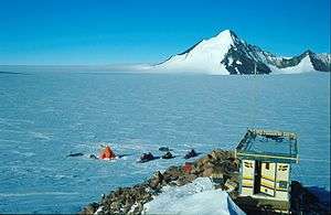 Svea field station in 2001 | |
 Svea Station Location of Svea Station in Antarctica | |
| Coordinates: 74°35′00″S 11°13′00″W / 74.583333°S 11.216667°WCoordinates: 74°35′00″S 11°13′00″W / 74.583333°S 11.216667°W | |
| Country |
|
| Location in Antarctica |
Heimefront Range Queen Maud Land |
| Administered by | Swedish Polar Research Secretariat |
| Established | 1987 |
| Population | |
| • Total |
|
| Type | Seasonal |
| Period | Summer |
| Status | Operational |
| Facilities |
|
| Website | Swdish Polar Research Secretariat |
The Svea Research Station is a Swedish research facility in Antarctica, established in 1987/1988.
It is located in the Scharffenbergbotnen valley in the Heimefrontfjella mountain range, about 400 km from the coast. Svea is a satellite station to the Wasa Research Station, and is used by small, transient research teams performing fieldwork in the area.
The station is currently the home base for two permanent monitoring projects: continual geodetic measurement using GPS technology, run by the Royal Institute of Technology in Stockholm, and a seismograph that records movements in the earth’s crust, run by the German Alfred Wegener Institute.
See also
References
This article is based on information from the Swedish Wikipedia-article about the same subject, and on information obtained from the official site of the Swedish Polar Research Secretariat.
| General |
| .svg.png) |
|---|---|---|
| Geographic regions | ||
| Waterways | ||
| Famous explorers | ||