Shirreff Base
| Shirreff Base | |
|---|---|
| Antarctic base | |
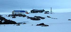 Cape Shirreff research station with the Chilean facilities on the left and the US ones on the right | |
 Shirreff Base Location of Shirreff Base in Antarctica | |
| Coordinates: 62°28′12″S 60°46′16″W / 62.469927°S 60.771241°WCoordinates: 62°28′12″S 60°46′16″W / 62.469927°S 60.771241°W | |
| Country |
|
| Location in Antarctica |
Ioannes Paulus II Peninsula Livingston Island South Shetland Islands Antarctica |
| Established | 1996 |
| Population | |
| • Total |
|
| Type | Seasonal |
| Period | Summer |
| Status | Operational |
Shirreff Base, is a seasonal field station in the South Atlantic operated by the United States of America (United States) opened in 1996. Situated on the east side of Cape Shirreff on Ioannes Paulus II Peninsula on Livingston Island in the South Shetland Islands off the Antarctic peninsula.
It is near the Chilean Base called Doctor Guillermo Mann.
Location
The base is located at 62°28′12″S 60°46′16″W / 62.469927°S 60.771241°W which is 1.58 km southeast of Cape Shirreff and 3.32 km west-northwest of Black Point (detailed Chilean mapping in 2004. Bulgarian mapping in 2005 and 2009).
Maps
- L.L. Ivanov et al., Antarctica: Livingston Island and Greenwich Island, South Shetland Islands (from English Strait to Morton Strait, with illustrations and ice-cover distribution), 1:100000 scale topographic map, Antarctic Place-names Commission of Bulgaria, Sofia, 2005.
- L.L. Ivanov. Antarctica: Livingston Island and Greenwich, Robert, Snow and Smith Islands. Scale 1:120000 topographic map. Troyan: Manfred Wörner Foundation, 2010. ISBN 978-954-92032-9-5 (First edition 2009. ISBN 978-954-92032-6-4)
- Antarctic Digital Database (ADD). Scale 1:250000 topographic map of Antarctica. Scientific Committee on Antarctic Research (SCAR), 1993–2016.
See also
References
- SCAR Composite Antarctic Gazetteer.
- Management Plan for Antarctic Specially Protected Area No. 149 Cape Shirreff and San Telmo Island.
- Photo of Shirreff Base with Black Point and Mount Friesland in the background. NOAA Fisheries Service’s Southwest Fisheries Science Center.
- Ivanov, L. General Geography and History of Livingston Island. In: Bulgarian Antarctic Research: A Synthesis. Eds. C. Pimpirev and N. Chipev. Sofia: St. Kliment Ohridski University Press, 2015. pp. 17–28. ISBN 978-954-07-3939-7
![]()


| General |
| .svg.png) |
|---|---|---|
| Geographic regions | ||
| Waterways | ||
| Famous explorers | ||