Esperanza Base
| Esperanza Base Base Esperanza | ||
|---|---|---|
| All-civilian Antarctic base | ||
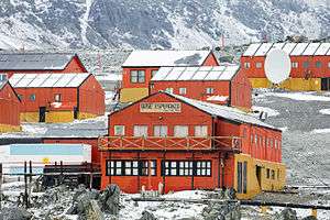 View of Esperanza Base, January 2016 | ||
| ||
|
Motto(s): Spanish: Permanencia, un acto de sacrificio ("Permanence, an act of sacrifice") | ||
 Esperanza Base Location of Esperanza Base in Antarctica | ||
| Coordinates: 63°23′51″S 56°59′52″W / 63.3975°S 56.997778°WCoordinates: 63°23′51″S 56°59′52″W / 63.3975°S 56.997778°W | ||
| Country |
| |
| Region | ||
| Location | ||
| Administered by | Argentine Antarctic Institute (under the supervision of the Argentine National Antarctic Directorate) | |
| Established | 1953 | |
| Named for |
Spanish: Base Esperanza ("Hope Base") | |
| Area | ||
| • Urban[lower-alpha 1] | 0.3744 ha (0.9252 acres) | |
| Elevation | 25 m (82 ft) | |
| Population (2014) | 55 | |
| Type | All-year round | |
| Period | Annual | |
| Status | Operational | |
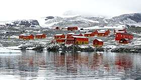
Esperanza base (Spanish: Base Esperanza, "Hope Base") is a permanent, all year-round Argentine research station in Hope Bay, Trinity Peninsula (Graham Land, Antarctic Peninsula). It is one of only two civilian settlements in Antarctica (the other being the Chilean Villa Las Estrellas). The Base's motto is "Permanencia, un acto de sacrificio" ("Permanence, an act of sacrifice").
Description
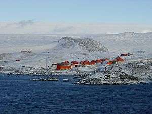
Built in 1953,[1][2][3] the base houses 55 inhabitants in winter, including 10 families and 2 school teachers. Provincial school #38 Presidente Raúl Ricardo Alfonsín (formerly named Julio Argentino Roca) was founded in 1978 and acquired independent status in 1997. It maintains the furthest South Scout troop. The base has an Argentine civil registry office where births and weddings are recorded.[4]The base has tourist facilities that are visited by about 1,100 tourists each year. The LRA 36 Radio Nacional Arcángel San Gabriel radio station started transmitting in 1979. A wind generator was installed in 2008, mounted by INVAP. video
The 43 buildings of the station have a combined space of 3,744 square metres (40,300 sq ft) covered;[5] 18,000 litres (4,800 US gal) of fuel are used annually by the four generators to produce electricity for the station. Research projects include: glaciology, seismology, oceanography, coastal ecology, biology, geology, and limnology.
People
The base has some measure of fame because it is the birthplace of Emilio Marcos Palma, the first person to be born in Antarctica. There have been at least ten other children born at the base.[6][7]
Climate
Like the rest of the Antarctic Peninsula, the base has a polar climate characterized by strong winds that descend downwards from Antarctic ice sheet.[8] These winds can exceed 250 km/h (160 mph), leading to blowing snow and reduced visibility.[8] The climate is classified as a polar tundra (ET) climate in the Köppen system.[9]
Mean monthly temperatures range from −10.5 °C (13.1 °F) in June, the coldest month to 1.4 °C (34.5 °F) in January, the warmest month.[8] During summer (December–February), the average high is between 3.7 to 4.3 °C (38.7 to 39.7 °F) while the average low is between −2.0 to −1.2 °C (28.4 to 29.8 °F).[8] In winter, mean temperatures are around −6.0 °C (21.2 °F).[8] The highest temperature recorded was 17.5 °C (63.5 °F) on 24 March 2015.[10] This reading is the highest temperature ever recorded on mainland Antarctica and its surrounding islands.[11] The lowest temperature ever recorded is −38.4 °C (−37.1 °F) on 18 July 1994.[12]
The temperature trend since 1948 is +0.0315 °C/yr (+0.0567 °F/yr) (annual), +0.0413 °C/yr (+0.0743 °F/yr) (winter) and +0.0300 °C/yr (+0.0540 °F/yr) (summer).
| Climate data for Esperanza (1981–2010, extremes 1945–present) | |||||||||||||
|---|---|---|---|---|---|---|---|---|---|---|---|---|---|
| Month | Jan | Feb | Mar | Apr | May | Jun | Jul | Aug | Sep | Oct | Nov | Dec | Year |
| Record high °C (°F) | 14.9 (58.8) |
15.5 (59.9) |
17.5 (63.5) |
15.9 (60.6) |
17.2 (63) |
13.3 (55.9) |
14.0 (57.2) |
13.0 (55.4) |
11.4 (52.5) |
17.0 (62.6) |
14.3 (57.7) |
14.6 (58.3) |
17.5 (63.5) |
| Average high °C (°F) | 4.3 (39.7) |
3.7 (38.7) |
1.2 (34.2) |
−2.1 (28.2) |
−4.0 (24.8) |
−6.2 (20.8) |
−6.3 (20.7) |
−4.6 (23.7) |
−2.3 (27.9) |
−0.4 (31.3) |
2.1 (35.8) |
3.8 (38.8) |
−0.9 (30.4) |
| Daily mean °C (°F) | 1.4 (34.5) |
0.7 (33.3) |
−2.3 (27.9) |
−6.1 (21) |
−8.2 (17.2) |
−10.4 (13.3) |
−10.5 (13.1) |
−9.0 (15.8) |
−6.5 (20.3) |
−4.3 (24.3) |
−1.1 (30) |
0.8 (33.4) |
−4.6 (23.7) |
| Average low °C (°F) | −1.2 (29.8) |
−2.0 (28.4) |
−5.6 (21.9) |
−9.7 (14.5) |
−12.1 (10.2) |
−14.3 (6.3) |
−14.8 (5.4) |
−13.2 (8.2) |
−10.4 (13.3) |
−8.0 (17.6) |
−4.2 (24.4) |
−1.9 (28.6) |
−8.1 (17.4) |
| Record low °C (°F) | −8.5 (16.7) |
−13.2 (8.2) |
−20.9 (−5.6) |
−26.0 (−14.8) |
−29.6 (−21.3) |
−30.0 (−22) |
−38.4 (−37.1) |
−32.0 (−25.6) |
−32.6 (−26.7) |
−23.2 (−9.8) |
−18.0 (−0.4) |
−9.7 (14.5) |
−38.4 (−37.1) |
| Average precipitation mm (inches) | 56.2 (2.213) |
65.0 (2.559) |
75.5 (2.972) |
59.1 (2.327) |
54.4 (2.142) |
47.4 (1.866) |
54.1 (2.13) |
72.1 (2.839) |
62.2 (2.449) |
56.4 (2.22) |
65.0 (2.559) |
59.0 (2.323) |
726.4 (28.598) |
| Average precipitation days (≥ 0.1 mm) | 14 | 14 | 17 | 17 | 14 | 11 | 13 | 15 | 15 | 15 | 16 | 16 | 177 |
| Average snowy days | 16 | 15 | 16 | 16 | 14 | 13 | 14 | 14 | 16 | 15 | 16 | 16 | 181 |
| Average relative humidity (%) | 82 | 80 | 80 | 80 | 80 | 79 | 80 | 80 | 79 | 80 | 81 | 80 | 80 |
| Mean monthly sunshine hours | 93.0 | 127.1 | 89.9 | 60.0 | 31.0 | 12.0 | 21.7 | 43.4 | 87.0 | 136.4 | 144.0 | 161.2 | 1,006.7 |
| Mean daily sunshine hours | 3.0 | 4.5 | 2.9 | 2.0 | 1.0 | 0.4 | 0.7 | 1.4 | 2.9 | 4.4 | 4.8 | 5.2 | 2.8 |
| Source #1: Servicio Meteorológico Nacional (temperature 1981–2010, precipitation and snowy days 1961–1990),[13][14][15] NOAA (precipitation 1961–1990)[16] | |||||||||||||
| Source #2: Meteo Climat (record highs and lows),[12] Deutscher Wetterdienst (sun, 1982–1990 and humidity, 1982–1995)[17] | |||||||||||||
Historic site
 | |
|
Grunden Rock lighthouse Antarctica | |
| Location |
Grunden Rock Lighthouse Esperanza Base Trinity Peninsula Antarctica |
|---|---|
| Coordinates | 63°23′43″S 56°58′32″W / 63.395139°S 56.975667°W |
| Year first constructed | n/a |
| Foundation | concrete base |
| Construction | concrete tower |
| Tower shape | cylindrical tower with lantern |
| Markings / pattern | red tower with two horizontal black bands |
| Height | 6 metres (20 ft)[18] |
| Focal height | 26 metres (85 ft)[18] |
| Light source | solar power |
| Range | 6 nautical miles (11 km; 6.9 mi)[18] |
| Characteristic | Fl W 2s.[18] |
| Admiralty number | G1389[18] |
| NGA number | 2756[18] |
| ARLHS number | ANC-002[19] |
| Managing agent | Argentine Navy |
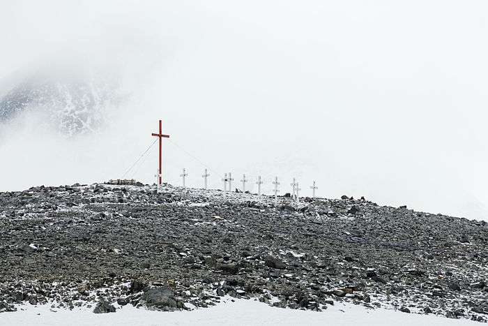
A group of items or structures of historic significance at, or close to, the base have been designated a Historic Site or Monument (HSM 40), following a proposal by Argentina to the Antarctic Treaty Consultative Meeting. These comprise a bust of General San Martin, a grotto with a statue of the Virgin of Lujan, a flagpole erected in 1955, and a cemetery with a stele commemorating Argentine expedition members who died in the area.[20]
General Martín Güemes Refuge
Refuge General Martín Güemes is the name given to two shelters in Antarctica. The first one is covered by ice, the second one is active. The refuge is Administered by the Argentine Army and depend on the Esperanza Base, which is responsible for the maintenance and the care. The two refuges are located on the Tabarin Peninsula on the eastern tip of the Trinity Peninsula on the Antarctic Peninsula 14 kilometres (8.7 mi) south of Esperanza.The refuges pay homage to Martín Miguel de Güemes, a military man who served an outstanding role in the Argentine war of independence.
General Martín Güemes I Refuge
The first refuge 63°29′00″S 57°00′00″W / 63.483333°S 57°W was located on the north east coast of the Duse Bay of the Trinity Peninsula and opened on October 23, 1953. Jorge Edgar Leal, at that time head of the newly created Esperanza Base, participated in its construction, being one of the first refuge installed by the Army and the second in the continental Antarctica. The refuge was destroyed by the ice in 1960.
General Martín Güemes II Refuge
The second refuge 63°30′14″S 57°07′25″W / 63.503911°S 57.123603°W is active and is located in the Tabarin Peninsula and was inaugurated on September 15, 1959. It has capacity for six people, food for a month, fuel, gas and first aid kit.[21]
See also
Notes
- ↑ Indoors area
References
- ↑ Interview with General Leal by the Meeting channel Archived 2014-10-27 at the Wayback Machine.
- ↑ official site Archived 2011-06-06 at the Wayback Machine.
- ↑ ESPERANZA at marambio.aq
- ↑ Registro civil "Base Esperanza" Archived January 17, 2010, at the Wayback Machine.
- ↑ Google Earth satellite images
- ↑ 60 años de Base Esperanza - Fundación Marambio
- ↑ El primer antártico es argentino Archived December 6, 2014, at the Wayback Machine. - Fundación Marambio
- 1 2 3 4 5 "Base Esperanza" (in Spanish). Servicio Meteorológico Nacional. Retrieved 4 March 2017.
- ↑ Peel, M. C.; Finlayson B. L. & McMahon, T. A. (2007). "Updated world map of the Köppen−Geiger climate classification" (PDF). Hydrol. Earth Syst. Sci. 11 (5): 1633–1644. doi:10.5194/hess-11-1633-2007. ISSN 1027-5606.
- ↑ Mccarthy, Tom (31 March 2015). "Antarctica records unprecedented high temperatures in two new readings". The Guardian. Retrieved 8 July 2015.
- ↑ "WMO Region VII (Antarctica mainland & adjoining islands): Highest Temperature". World Meteorological Organization. Retrieved 1 March 2017.
- 1 2 "Station Base Esperanza" (in French). Meteo Climat. Retrieved June 6, 2016.
- ↑ "Estadísticas Climatológicas Normales - período 1981-2010" (in Spanish). Servicio Meteorológico Nacional. Retrieved January 18, 2018.
- ↑ "B. Espernza Statistical Data (1961-1990)" (in Spanish). Servicio Meteorológico Nacional. Retrieved January 23, 2016.
- ↑ "Valores Medios de Temperatura y Precipitación-Antártida: Base Esperanza" (in Spanish). Servicio Meteorológico Nacional. Retrieved January 23, 2016.
- ↑ "Base Esperanza Climate Normals 1961–1990". National Oceanic and Atmospheric Administration. Retrieved January 23, 2016.
- ↑ "Klimatafel von Esperanza (Argentinien) / Antarkt. Halbinsel / Antarktis" (PDF). Baseline climate means (1961-1990) from stations all over the world (in German). Deutscher Wetterdienst. Retrieved January 23, 2016.
- 1 2 3 4 5 6 List of Lights, Pub. 111: The West Coasts of North and South America (Excluding Continental U.S.A. and Hawaii), Australia, Tasmania, New Zealand, and the Islands of the North and South Pacific Oceans (PDF). List of Lights. United States National Geospatial-Intelligence Agency. 2017.
- ↑ "Antarctica". The Lighthouse Directory. University of North Carolina at Chapel Hill. Retrieved 22 May 2017.
- ↑ "List of Historic Sites and Monuments approved by the ATCM (2012)" (PDF). Antarctic Treaty Secretariat. 2012. Retrieved 2013-12-31.
- ↑ "Refugio General Martín Güemes". Wikipedia Espanol. Wikimedia Foundation Inc. Retrieved September 18, 2018.
Further reading
- Antarctica. Sydney: Reader's Digest, 1985, p. 156-157.
- Child, Jack. Antarctica and South American Geopolitics: Frozen Lebensraum. New York: Praeger Publishers, 1988, p. 73.
- Lonely Planet, Antarctica: a Lonely Planet Travel Survival Kit, Oakland, CA: Lonely Planet Publications, 1996, 302-304.
- Stewart, Andrew, Antarctica: An Encyclopedia. London: McFarland and Co., 1990 (2 volumes), p. 469.
- U.S. National Science Foundation, Geographic Names of the Antarctic, Fred G. Alberts, ed. Washington: NSF, 1980.
External links
| Wikimedia Commons has media related to Esperanza Station. |
- Council Of Managers Of National Antarctic Programs: Base Esperanza
- Temperatures
- (in Spanish) Argentine Army's site about the base
- Official website Direccion Nacional del Antartico
- (in Spanish) Fundaciòn Marambio Esperanza Base page
- COMNAP Antarctic Facilities
- COMNAP Antarctic Facilities Map
| General |
| .svg.png) |
|---|---|---|
| Geographic regions | ||
| Waterways | ||
| Famous explorers | ||