Plumstead Township, Bucks County, Pennsylvania
| Plumstead Township | |
|---|---|
| Township | |
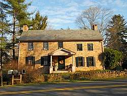 House in the Dyerstown Historic District | |
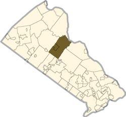 Location of Plumstead Township in Bucks County | |
 Plumstead Township Location in Pennsylvania and the United States  Plumstead Township Plumstead Township (the US) | |
| Coordinates: 40°23′00″N 75°06′59″W / 40.38333°N 75.11639°WCoordinates: 40°23′00″N 75°06′59″W / 40.38333°N 75.11639°W | |
| Country | United States |
| State | Pennsylvania |
| County | Bucks |
| Area[1] | |
| • Total | 27.28 sq mi (70.66 km2) |
| • Land | 27.16 sq mi (70.35 km2) |
| • Water | 0.12 sq mi (0.30 km2) |
| Elevation | 394 ft (120 m) |
| Population (2010) | |
| • Total | 12,442 |
| • Estimate (2016)[2] | 13,687 |
| • Density | 503.87/sq mi (194.55/km2) |
| Time zone | UTC-5 (EST) |
| • Summer (DST) | UTC-4 (EDT) |
| Area code(s) | 215 and 267 |
| FIPS code | 42-017-61616 |
| Website |
www |
Plumstead Township is a township in Bucks County, Pennsylvania, United States. The population was 12,442 at the 2010 census.
History
The Gardenville-North Branch Rural Historic District, Dyerstown Historic District, and Loux Covered Bridge are listed on the National Register of Historic Places.[3]
Geography
According to the United States Census Bureau, the township has a total area of 27.2 square miles (70.5 km²), of which, 27.2 square miles (70.3 km²) of it is land and 0.1 square miles (0.1 km²) of it (0.18%) is water. It is drained by the Delaware River, which separates it from New Jersey. Past and present villages include Carversville (also in Solebury Township,) Cross Keys (also in Doylestown Township,) Curley Hill, Danboro, Dyerstown, Fountainville, Gardenville, Griers Corner (also in Bedminster and Hilltown Townships,) Groveland, Hinkletown, Kendigtown, Keplers Corner, Landisville, Lower Black Eddy, Lumberville, Melchers Corner, Plumsteadville, Point Pleasant (also in Tinicum Township), Smiths Corner, Smithtown, and Wismer.[4]
Ralph Stover State Park is located in Plumstead Township and Tinicum Township.
Natural features include Cabin Run, Curley Hill, Geddes Run, Hickory Run, Irish Run, Moss Giel Rock, Slobbery Run, and Tohickon Creek.[4]
Neighboring municipalities
- Solebury Township (east)
- Buckingham Township (southeast)
- Doylestown Township (south)
- New Britain Township (southwest)
- Hilltown Township (southwest)
- Bedminster Township (northwest)
- Tinicum Township (north)
- Kingwood Township, New Jersey (northeast)
Demographics
| Historical population | |||
|---|---|---|---|
| Census | Pop. | %± | |
| 1930 | 2,080 | — | |
| 1940 | 2,168 | 4.2% | |
| 1950 | 2,353 | 8.5% | |
| 1960 | 3,354 | 42.5% | |
| 1970 | 4,682 | 39.6% | |
| 1980 | 5,153 | 10.1% | |
| 1990 | 6,289 | 22.0% | |
| 2000 | 11,409 | 81.4% | |
| 2010 | 12,442 | 9.1% | |
| Est. 2016 | 13,687 | [2] | 10.0% |
| [5] | |||
As of the 2010 census, the township was 94.1% White, 0.7% Black or African American, 0.1% Native American, 1.7% Asian, and 1.4% were two or more races. 4.7% of the population were of Hispanic or Latino ancestry.[6]
As of the census[7] of 2000, there were 11,409 people, 3,938 households, and 3,130 families residing in the township. The population density was 420.1 people per square mile (162.2/km²). There were 4,103 housing units at an average density of 151.1/sq mi (58.3/km²). The racial makeup of the township was 96.36% White, 0.71% African American, 0.28% Native American, 1.01% Asian, 0.01% Pacific Islander, 0.85% from other races, and 0.78% from two or more races. Hispanic or Latino of any race were 1.98% of the population.
There were 3,938 households, out of which 45.1% had children under the age of 18 living with them, 69.8% were married couples living together, 6.7% had a female householder with no husband present, and 20.5% were non-families. 15.6% of all households were made up of individuals, and 3.7% had someone living alone who was 65 years of age or older. The average household size was 2.89 and the average family size was 3.26.
In the township the population was spread out, with 30.9% under the age of 18, 4.9% from 18 to 24, 36.9% from 25 to 44, 20.8% from 45 to 64, and 6.5% who were 65 years of age or older. The median age was 34 years. For every 100 females, there were 101.0 males. For every 100 females age 18 and over, there were 98.4 males.
The median income for a household in the township was $70,332, and the median income for a family was $80,946. Males had a median income of $56,263 versus $33,633 for females. The per capita income for the township was $29,411. About 2.1% of families and 2.5% of the population were below the poverty line, including 1.8% of those under age 18 and 4.0% of those age 65 or over.
References
- ↑ "2016 U.S. Gazetteer Files". United States Census Bureau. Retrieved Aug 13, 2017.
- 1 2 "Population and Housing Unit Estimates". Retrieved June 9, 2017.
- ↑ National Park Service (2010-07-09). "National Register Information System". National Register of Historic Places. National Park Service.
- 1 2 MacReynolds, George, Place Names in Bucks County, Pennsylvania, Doylestown, Bucks County Historical Society, Doylestown, PA, 1942, P1.
- ↑ http://www.dvrpc.org/data/databull/rdb/db82/appedixa.xls
- ↑ https://www.usatoday.com/news/nation/census/profile/PA
- ↑ "American FactFinder". United States Census Bureau. Retrieved 2008-01-31.
External links
| Wikimedia Commons has media related to Plumstead Township, Bucks County, Pennsylvania. |
