Eastern Neisse
| Eastern Neisse (Nysa Kłodzka) | |
| River | |
 | |
| Country | Poland |
|---|---|
| Regions | Lower Silesian Voivodeship, Opole Voivodeship |
| Source | |
| - location | Jodłów, Lower Silesian Voivodeship, Poland |
| - coordinates | 50°9′45″N 16°45′8″E / 50.16250°N 16.75222°E |
| Mouth | Oder |
| - location | Rybna, Opole Voivodeship, Poland |
| - coordinates | 50°49′9″N 17°39′30″E / 50.81917°N 17.65833°ECoordinates: 50°49′9″N 17°39′30″E / 50.81917°N 17.65833°E |
| Length | 189 km (117 mi) |
| Basin | 4,570 km2 (1,764 sq mi) |
| Discharge | mouth |
| - average | 37.7 m3/s (1,331 cu ft/s) |
| Progression | Oder→ Baltic Sea |
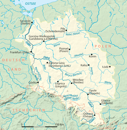
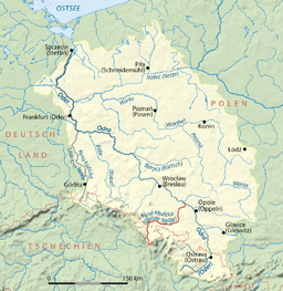 Oder basin, Nysa Kłodzka in red | |
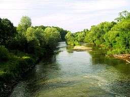
The Eastern Neisse,[1] also known by its Polish name of Nysa Kłodzka (German: Glatzer Neiße, Czech: Kladská Nisa), is a river in southwestern Poland, a left tributary of the Oder, with a length of 188 km (21st longest) and a basin area of 4,570 km² (3,742 in Poland).[2]
Prior to World War II it was part of Germany. During the Yalta Conference it was discussed by the Western Allies as one possible line of the western Polish border. Attempts were made to negotiate a compromise with the Soviets on the new Polish-German frontier; it was suggested that the Eastern Neisse be made the line of demarcation. This would have meant that (East) Germany could have retained approximately half of Silesia, including most of Wrocław (formerly Breslau). However the Soviets rejected the suggestion at the Potsdam Conference and insisted that the southern boundary between Germany and Poland be drawn further west, at the Lusatian Neisse.[3][1]
Floods
The Eastern Neisse originates in the Śnieżnik mountain range of the Sudetes, near the border with the Czech Republic. It is partially regulated. The river has often left its banks and flooded nearby towns, at times destroying them completely. Town chronicles from Kłodzko mention floods in the following years:
- 14th century: 1310
- 15th century: 1441, 1464, 1474
- 16th century: 1500, 1522, 1524, 1560, 1566, 1570, 1587, 1589, 1591, 1598,
- 17th century: 1602, 1603, 1605, 1610, 1611, 1612, 1625, 1646, 1652, 1655, 1689, 1693, 1696
- 18th century: 1702, 1703, 1713, 1724, 1735, 1736, 1740, 1755, 1763, 1767, 1775, 1785, 1787, 1789, 1799
- 19th century: 1804, 1806, 1827, 1828, 1829, 1831, 1850, 1854, 1879, 1881, 1883, 1891, 1897
- 20th century: 1900, 1903, 1907, 1938, 1952, 1997, 1998
Towns
Until 1945, these communities were situated on German territory and largely populated by Germans before they were driven out at the end of the Second World War. German names are indicated in italics.
- Bardo (Wartha)
- Bystrzyca Kłodzka (Habelschwerdt)
- Kamieniec Ząbkowicki (Kamenz N.S.)
- Kłodzko (Glatz)
- Lewin Brzeski (Löwen)
- Międzylesie (Mittelwalde) - both names mean "Middle Wood"
- Nysa (Neiße)
- Otmuchów (Ottmachau)
- Paczków (Patschkau)
See also
| Wikimedia Commons has media related to Nysa Kłodzka. |
- Lusatian Neisse (Lužická Nisa, Nysa Łużycka)
- Raging Neisse (Nysa Szalona)
- Rivers of Poland
- Geography of Poland
Notes
- 1 2 Plokhy S.M. Yalta: The Price of Peace, New York: Viking, 2010.
- ↑ Statistical Yearbook of the Republic of Poland 2017, Statistics Poland, p. 85-86
- ↑ Brogan, Patrick (1990). The Captive Nations: Eastern Europe, 1945-1990. Avon books, p. 18. ISBN 0380763044
Tributaries of the Oder / Odra | ||
|---|---|---|
| Main tributaries of the left bank |
|  |
| Main tributaries of the right bank |
| |
| Distributary | ||
| Cities | ||
Silesia topics | |||||||||||||||||||||||||||||
|---|---|---|---|---|---|---|---|---|---|---|---|---|---|---|---|---|---|---|---|---|---|---|---|---|---|---|---|---|---|
| |||||||||||||||||||||||||||||
| |||||||||||||||||||||||||||||
| |||||||||||||||||||||||||||||
| |||||||||||||||||||||||||||||
| |||||||||||||||||||||||||||||