Schwedt
| Schwedt | ||
|---|---|---|
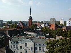 Old town | ||
| ||
 Schwedt Location of Schwedt within Uckermark district 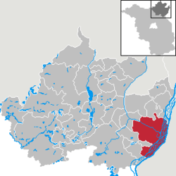 | ||
| Coordinates: 53°03′N 14°16′E / 53.050°N 14.267°ECoordinates: 53°03′N 14°16′E / 53.050°N 14.267°E | ||
| Country | Germany | |
| State | Brandenburg | |
| District | Uckermark | |
| Government | ||
| • Mayor | Jürgen Polzehl (SPD) | |
| Area | ||
| • Total | 200.12 km2 (77.27 sq mi) | |
| Elevation | 6 m (20 ft) | |
| Population (2017-12-31)[1] | ||
| • Total | 30,075 | |
| • Density | 150/km2 (390/sq mi) | |
| Time zone | CET/CEST (UTC+1/+2) | |
| Postal codes | 16303 | |
| Dialling codes | 03332, 033336 | |
| Vehicle registration | UM | |
| Website | www.schwedt.eu | |

Schwedt (or Schwedt/Oder; German pronunciation: [ˈʃveːt]) is a town in northeastern Brandenburg, Germany. With the official status of a Große kreisangehörige Stadt (major district town), it is the largest town of the Uckermark district, located near the Oder River close to the border with Poland.
Overview
The formerly agrarian town today has one of the largest oil refineries (PCK Raffinerie GmbH) in Germany, established in 1958 and connected to the Russian Druzhba pipeline network, and is the largest location of paper industry (UPM) in Europe. Most industries were located in the remote area during communist rule in the 1960s and 1970s.
Large residential areas were built for the workers moving to Schwedt. About 9% of the town's flats are in prefab concrete buildings (Plattenbau) dating from the era. As many jobs were lost after German reunification and the return to market economy, Schwedt has lost a quarter of its population since 1990. In recent decades, Schwedt became a model town for the demolition of Plattenbau housing to combat urban decay.
Geography
Schwedt is situated in the east of the historic Uckermark region stretching from the Oder to the Havel River. It is situated on an sandur at the western edge of the Oder floodplain running along the German-Polish border, which in 1995 was declared as the Lower Oder Valley National Park nature reserve. Across the river and the border, about 10 km (6.2 mi) to the southeast, is the Polish town of Chojna (formerly Königsberg in der Neumark). The nearest German towns are Angermünde (about 18 km (11 mi) to the west) and Gartz (18 km (11 mi) down the Oder).
Local districts
In a 1974 municipal reform, the neighbouring village of Heinersdorf was incorporated into Schwedt, followed by Blumenhagen, Gatow and Kunow in 1993, by Kummerow in 1998, by Criewen and Zützen in 2001, Stendell in 2002, and the former town Vierraden in 2003. With 200.12 km2 (77.27 sq mi) Schwedt is among the 100 largest German municipalities by area.
Nearest cities and towns
Gartz (Germany), Penkun (Germany), Szczecin (Poland), Gryfino (Poland), Cedynia (Poland), Chojna (Poland), Mieszkowice (Poland), Moryń (Poland), Trzcińsko-Zdrój (Poland), Myślibórz (Poland), Pyrzyce (Poland)
History
After the Migration Period, the area had been settled by Polabian Slavs. From 937 onwards the lands of the Slavic Ukrani tribes in the west were subued by the Saxon forces of Margrave Gero and incorporated into his vast Marca Geronis, while the lands east of the Oder were held by Pomeranian tribes under pressure by the Polish forces of Duke Mieszko I. The Saxon Northern March was lost in the Great Slav Rising of 983, and not before 1147 the Saxon count Albert the Bear again invaded the lands on the Oder river, which remained disputed between the newly established Margraviate of Brandenburg and the Pomeranian dukes.
The settlement of Schwedt was first mentioned in a 1265 deed. In the course of the Brandenburg–Pomeranian conflict, the Brandenburg margrave Louis II the Roman ceded it to Duke Barnim III of Pomerania in 1354. It was again besieged by the first Hohenzollern margrave Frederick I in 1434, but to no avail. In 1481 the Thuringian counts of Hohnstein acquired the estates; they granted town privileges to Schwedt as well as to neighbouring Vierraden and introduced the Protestant Reformation.
The rise of Schwedt came to an end with the extinction of the Hohnstein counts in 1609 and the disastrous Thirty Years' War, when the town on the road from Stettin to Berlin was plundered several times. In 1631 King Gustavus Adolphus of Sweden, after landing in Pomerania, camped here on his way to the Battle of Breitenfeld. Six years later the Swedish field marshal Johan Banér set the town on fire, after its citizens refused to capitulate.
During the Great Northern War, the Treaty of Schwedt was signed in the town.
Near the end of World War II, over two months of heavy fighting destroyed an estimated 85 percent of the town, including its castle, the Schwedter Schloss. The Soviet Army occupied Schwedt on April 26, 1945, two weeks before the final defeat of Nazi Germany.[2] During the 1960s, the government of the DDR expanded housing and encouraged people to move to Schwedt, a trend that ended with the fall of Communism.
Demography
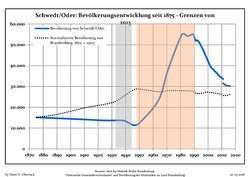 Development of population since 1875 within the current Boundaries (Blue Line: Population; Dotted Line: Comparison to Population development in Brandenburg state; Grey Background: Time of Nazi Germany; Red Background: Time of communist East Germany)
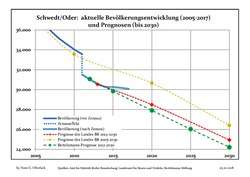 Recent Population Development and Projections (Population Development before Census 2011 (blue line); Recent Population Development according to the Census in Germany in 2011 (blue bordered line); Projection by the Brandenburg state for 2005-2030 (yellow line); Projection by the Brandenburg state for 2014-2030 (red line); Projection by the Bertelsmann Foundation for 2012-2030 (green line)
| Schwedt/Oder: Population development within the current boundaries (2017)[3] | ||||||||||||||||||||||||||||||||||||||||||||||||||||||||||||||||||||||||||||||||||||||||||||||||||||||||||||||||||||||||||||||||||||||
|---|---|---|---|---|---|---|---|---|---|---|---|---|---|---|---|---|---|---|---|---|---|---|---|---|---|---|---|---|---|---|---|---|---|---|---|---|---|---|---|---|---|---|---|---|---|---|---|---|---|---|---|---|---|---|---|---|---|---|---|---|---|---|---|---|---|---|---|---|---|---|---|---|---|---|---|---|---|---|---|---|---|---|---|---|---|---|---|---|---|---|---|---|---|---|---|---|---|---|---|---|---|---|---|---|---|---|---|---|---|---|---|---|---|---|---|---|---|---|---|---|---|---|---|---|---|---|---|---|---|---|---|---|---|---|
|
|
| ||||||||||||||||||||||||||||||||||||||||||||||||||||||||||||||||||||||||||||||||||||||||||||||||||||||||||||||||||||||||||||||||||||
Notable people
- Leonhardt von Blumenthal (1810-1900), Prussian Field Marshal,
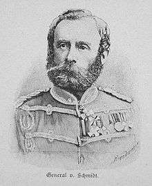
- Karl von Schmidt (1817-1875), Prussian cavalry commander
- Paul von Hintze (1864-1941), naval officer, diplomat and politician
- Max Lemke (1895-1985), a German officer, Major-General last in World War II
- Heinz von Cleve (1897-1984), German actor [4]
- Horst Wendlandt (1922-2002), film producer
- Jörg Hoffmann – (born 1970), freestyle swimmer
- Britta Steffen – (born 1983), Freestyle swimmer - former holder of the world record in women's 50 and 100 metre freestyle.
- Julia Brendler (born 1975), actress
International relations
Schwedt is twinned with:
References
- ↑ "Bevölkerung im Land Brandenburg nach amtsfreien Gemeinden, Ämtern und Gemeinden 31. Dezember 2017 (Fortgeschriebene amtliche Einwohnerzahlen auf Grundlage des Zensus 2011)". Amt für Statistik Berlin-Brandenburg (in German). 2018.
- ↑ [Template:Waybackarchiv Schwedt war menschenleer. In: Märkische Oderzeitung. 27. April 2005]
- ↑ Detailed data sources are to be found in the Wikimedia Commons.Population Projection Brandenburg at Wikimedia Commons
- ↑ Geburtsregister der Stadt Schwedt, Eintrag Nr. 182 vom 1. Juli 1897.
External links
| Wikimedia Commons has media related to Schwedt. |

- Official website (in German)
- Official website (in English)
- official website of National Park "Unteres Odertal" (in German)
- official website of PCK Raffinerie GmbH (in German)