Görlitz (district)
| Görlitz | ||
|---|---|---|
| District | ||
| ||
 | ||
| Country |
| |
| State | Saxony | |
| Capital | Görlitz | |
| Area | ||
| • Total | 2,106 km2 (813 sq mi) | |
| Population (31 December 2017)[1] | ||
| • Total | 256,587 | |
| • Density | 120/km2 (320/sq mi) | |
| Time zone | UTC+01:00 (CET) | |
| • Summer (DST) | UTC+02:00 (CEST) | |
| Vehicle registration | GR, LÖB, NOL, NY, WSW, ZI | |
| Website |
www | |
Görlitz (German: Landkreis Görlitz; Upper Sorbian: Wokrjes Zhorjelc; Czech: Zemský okres Zhorelec) is a district (Kreis) in the Free State of Saxony, Germany. It is named after its capital city Görlitz. It borders (from the west and clockwise) the district of Bautzen, the state Brandenburg, Poland and the Czech Republic.
History
The district was established in August 2008 by merging three smaller districts: the district of Löbau-Zittau, Niederschlesischer Oberlausitzkreis (Lower Silesian Upper Lusatia district) and the urban district of Görlitz.
Geography
The district comprises the south-eastern part of Lusatia and west part of Silesia, including part of the Lausitzer Bergland. The Lusatian Neisse forms its eastern border, the Spree flows through the western part of the district.
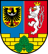
Coat of arms
The coat of arms of Görlitz district contains references to the various territories the district has been part of in the past. The black eagle with the crescent over its chest refers to Silesia. The crowned lion with two tails refers to Bohemia. The wall refers to the city of Bautzen and Upper Lusatia, and the lime leaves refer to the Sorbian community.
Towns and municipalities
| Towns | Municipalities | ||
|---|---|---|---|
References
- ↑ "Aktuelle Einwohnerzahlen nach Gemeinden 2017] (Einwohnerzahlen auf Grundlage des Zensus 2011)" (PDF). Statistisches Landesamt des Freistaates Sachsen (in German). October 2018.
External links
![]()
- Official website (German)
| Urban districts | |
|---|---|
| Rural districts | |
| Former urban districts | |
| Former rural districts | |