Notre-Dame-du-Sacré-Cœur-d'Issoudun, Quebec
| Notre-Dame-du-Sacré-Cœur -d'Issoudun Issoudun | |
|---|---|
| Parish municipality | |
 | |
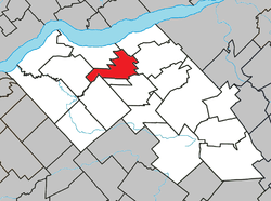 Location within Lotbinière RCM | |
 Issoudun Location in southern Quebec | |
| Coordinates: 46°35′N 71°37′W / 46.58°N 71.62°WCoordinates: 46°35′N 71°37′W / 46.58°N 71.62°W[1] | |
| Country |
|
| Province |
|
| Region | Chaudière-Appalaches |
| RCM | Lotbinière |
| Constituted | January 4, 1909 |
| Government[2] | |
| • Mayor | Annie Thériault |
| • Federal riding |
Lotbinière— Chutes-de-la-Chaudière |
| • Prov. riding | Lotbinière-Frontenac |
| Area[2][3] | |
| • Total | 60.60 km2 (23.40 sq mi) |
| • Land | 60.00 km2 (23.17 sq mi) |
| Population (2011)[3] | |
| • Total | 869 |
| • Density | 14.5/km2 (38/sq mi) |
| • Pop 2006-2011 |
|
| • Dwellings | 338 |
| Time zone | UTC−5 (EST) |
| • Summer (DST) | UTC−4 (EDT) |
| Postal code(s) | G0S 1L0 |
| Area code(s) | 418 and 581 |
| Highways |
|
| Website |
www |
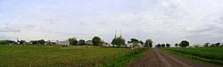
Notre-Dame-du-Sacré-Cœur-d'Issoudun is a parish municipality in the Lotbinière Regional County Municipality in the Chaudière-Appalaches region of Quebec, Canada. Its population is 869 as of the Canada 2011 Census. It is simply known as Issoudun, given the length of the official name.
The name honours the origin of a group of Missionaries of the Sacred Heart who came to Quebec City in 1900, from Issoudun, France.
On August 11, 1957, a Maritime Central Airways DC-4 crashed near Issoudun, killing 79 people.[1]
References
External links

- Commission de toponymie du Québec
- Ministère des Affaires municipales, des Régions et de l'Occupation du territoire
Places adjacent to Notre-Dame-du-Sacré-Cœur-d'Issoudun, Quebec | ||||||||||
|---|---|---|---|---|---|---|---|---|---|---|
| ||||||||||
| Municipalities | |
|---|---|
| Parishes | |
| Villages | |
| |
This article is issued from
Wikipedia.
The text is licensed under Creative Commons - Attribution - Sharealike.
Additional terms may apply for the media files.