Saint-Édouard-de-Lotbinière, Quebec
| Saint-Édouard-de-Lotbinière | |
|---|---|
| Parish municipality | |
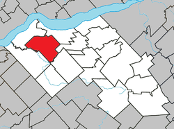 Location within Lotbinière RCM. | |
 Saint-Édouard-de-Lotbinière Location in southern Quebec. | |
| Coordinates: 46°34′N 71°50′W / 46.567°N 71.833°WCoordinates: 46°34′N 71°50′W / 46.567°N 71.833°W[1] | |
| Country |
|
| Province |
|
| Region | Chaudière-Appalaches |
| RCM | Lotbinière |
| Constituted | December 1, 1862 |
| Government[2] | |
| • Mayor | Alain Soucy |
| • Federal riding |
Lotbinière— Chutes-de-la-Chaudière |
| • Prov. riding | Lotbinière-Frontenac |
| Area[2][3] | |
| • Total | 98.50 km2 (38.03 sq mi) |
| • Land | 98.54 km2 (38.05 sq mi) |
|
There is an apparent contradiction between two authoritative sources | |
| Population (2011)[3] | |
| • Total | 1,248 |
| • Density | 12.7/km2 (33/sq mi) |
| • Pop 2006-2011 |
|
| • Dwellings | 531 |
| Time zone | UTC−5 (EST) |
| • Summer (DST) | UTC−4 (EDT) |
| Postal code(s) | G0S 1Y0 |
| Area code(s) | 418 and 581 |
| Highways |
|
| Website |
www.municipalite. st-edouard.qc.ca |
Saint-Édouard-de-Lotbinière is a parish municipality in the Lotbinière Regional County Municipality in the Chaudière-Appalaches region of Quebec, Canada. Its population is 1,248 as of the Canada 2011 Census. It is named after reverend Édouard Faucher, founder and first priest of the parish, and René-Louis Chartier de Lotbinière, first owner of the seigneurie in which Saint-Édouard lay.
References
Places adjacent to Saint-Édouard-de-Lotbinière, Quebec | ||||||||||
|---|---|---|---|---|---|---|---|---|---|---|
| ||||||||||
| Municipalities | |
|---|---|
| Parishes | |
| Villages | |
| |
This article is issued from
Wikipedia.
The text is licensed under Creative Commons - Attribution - Sharealike.
Additional terms may apply for the media files.