Les Etchemins Regional County Municipality
| Les Etchemins | |
|---|---|
| Regional county municipality | |
 | |
| Coordinates: 46°24′N 70°21′W / 46.400°N 70.350°WCoordinates: 46°24′N 70°21′W / 46.400°N 70.350°W[1] | |
| Country |
|
| Province |
|
| Region | Chaudière-Appalaches |
| Effective | January 1, 1982 |
| County seat | Lac-Etchemin |
| Government[2] | |
| • Type | Prefecture |
| • Prefect | Hector Provençal |
| Area[2][3] | |
| • Total | 1,819.40 km2 (702.47 sq mi) |
| • Land | 1,810.33 km2 (698.97 sq mi) |
| Population (2011)[3] | |
| • Total | 17,254 |
| • Density | 9.5/km2 (25/sq mi) |
| • Pop 2006-2011 |
|
| • Dwellings | 8,651 |
| Time zone | UTC−5 (EST) |
| • Summer (DST) | UTC−4 (EDT) |
| Area code(s) | 418 and 581 |
| Website |
www |
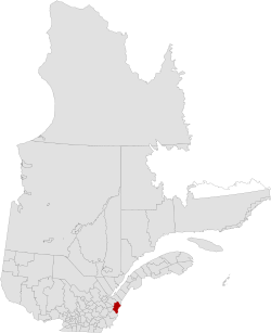
Les Etchemins is a regional county municipality in the Chaudière-Appalaches region of eastern Quebec, Canada. It is named for the Etchemin River which finds its source in the region, as well as Etchemin Lake. Lac-Etchemin is the seat of the RCM. Les Etchemins can be found on the Maine border, southeast of Quebec City.
Subdivisions
There are 13 subdivisions within the RCM:[2]
Transportation
Access Routes
Highways and numbered routes that run through the municipality, including external routes that start or finish at the county border:[4]
See also
References
External links
Adjacent Counties & Equivalent Territories | |
|---|---|
| Regional county municipalities and equivalent territories | |
|---|---|
| Municipalities | |
This article is issued from
Wikipedia.
The text is licensed under Creative Commons - Attribution - Sharealike.
Additional terms may apply for the media files.