North Bihar
| North Bihar उत्तर बिहार شمال بہار | |
|---|---|
| Coordinates: 26°04′N 85°27′E / 26.07°N 85.45°ECoordinates: 26°04′N 85°27′E / 26.07°N 85.45°E | |
| Country |
|
| State | Bihar |
| Time zone | UTC+5:30 (IST) |
| Lok Sabha | About 21 |
| Vidhan Sabha | 127+2 |
| Districts | 18+1 |
| Main Languages | Maithili, Hindi, Urdu |
| Largest Cities | Muzaffarpur, Purnea, Darbhanga, Motihari |
| Largest District | East Champaran |
| Website |
www |
North Bihar is a term used for the region of Bihar which lies north of the Ganga river and east of Gandak river.[1]
Towns and cities

- Naugachia is a sub division in Bhagalpur district. It is famous for Banana farming; and known as Kelanchal of Bihar.[2]
- Purnia is the headquarters of Purnia division and Purnia district. It is also the birthplace of former Indian cricketer Kirti Azad.
- Katihar is the headquarters of Katihar district. Katihar is known for Jute production.[3]
- Kishanganj is the headquarters of Kishanganj district. It is the easternmost district of Bihar. A part of this district of known as chicken neck region of India.[4]
- Araria is the headquarters of Araria district. NH 57 connect Araria to other parts of the state.
- Madhepura is the headquarters of Madhepura district. This district was curved out from Saharsa district. This is a flood-prone district of Kosi region.
- Supaul is the headquarters of Supaul district. A bridge on kosi region was built in 2012 near Nirmali in Supaul, which linked the two parts of Mithila region.[5]
- Saharsa is the headquarters of Saharsa district and Kosi division.
- Khagaria is the headquarters of Khagaria district. Two major rivers of North Bihar Ganga river and the Kosi river flows through the district.[6]
- Begusarai is the headquarters of Begusarai district. Barauni and Begusarai are the main industrial hub of North Bihar. Barauni is one of the important railway junctions of Bihar.[7]
- Samastipur is the headquarters of Samastipur district.
- Darbhanga is the headquarters of Darbhanga district and Darbhanga division. Darbhanga is the cultural capital of bihar as well as The capital of Mithilanchal. It is the 2nd largest city in North Bihar.
- Madhubani is the headquarters of Madhubani district. Jainagar in Madhubani district connects North Bihar to Janakpurdham in Mithila region of Nepal.
- Hajipur is the headquarters of Vaishali district, located on northern bank of Ganga river, opposite to Patna on southern bank.
- Muzaffarpur[8][9][10] is the largest city as well as the economic and financial capital of North Bihar. It the headquarters of Muzaffarpur district and Tirhut division. All the important roadways (like NH 27, NH 28, NH 57, NH 77, NH 102) and railways (like Muzaffarpur-Hajipur, Muzaffarpur-Motihari, Muzaffarpur-Sitamarhi, Muzaffarpur-Samastipur) have their junction in the city. This makes Muzaffarpur-the city with best connectivity in North Bihar.[11]
- Sitamarhi is the headquarters of Sitamarhi district. It has vedic importance as Goddess Sita is believed to be unearthed here.[12]
- Sheohar is the headquarters of Sheohar district, the smallest district of North Bihar. It was curved out from Sitamarhi District.[13]
- Motihari is the headquarters of East Champaran district. Mahatma Gandhi had launched non-cooperation movement here. It has been announced to establish a Central University in Motihari. This would be the first nationalized University in North Bihar.[14]
- Bettiah is the headquarters of West Champaran district. It is the westernmost district of North Bihar and Northernmost district of Bihar state as whole.[15]
Languages
Maithili is the mother tongue of most of the people from North Bihar.[16] Different variances of Maithili is spoken in the region.[17]
- Bajjika variety of Maithili or the Western Maithili is spoken in East Champaran, West Champaran, Muzaffarpur district, Vaishali district, Sitamarhi district, Sheohar district.
- Central dialect or the Standard dialect of Maithili is spoken in wider region including Darbhanga division, Kosi division and Purnia division. However, some linguists classify the Maithili spoken in Purnia division as Eastern dialect of Maithili.
- Jolaha dialect of Maithili is spoken by Muslims of North Bihar.
Proposed state
There is an ongoing movement in the Maithili speaking region of Bihar for a separate Mithila state. What will be the capital of the state has yet to be decided, however, Darbhanga is the most likely candidate. Other potential capitals include Muzaffarpur, Purnia and Begusarai.[18]
Economy
Agricultural economy
Agriculture is the main economic activity of the region.
The above industries have generated considerable employment and have also been helpful in establishing a number of small industries including a few cottage industries. The most important item that is manufactured in Muzaffarpur city is railway wagon. While Darbhanga is well known for producing quality makhana (fox nut) most of them are exported to other parts of India and dudhia malda variety of mangoes.
Rivers and floods
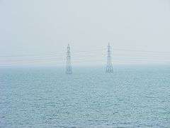
There are several rivers flowing through this region from north to south and merge in the Ganges river.[19] These rivers along with floods bring every year fertile soil to the region. However, sometimes government sponsored floods causes loss of thousands of lives. Major rivers of North Bihar are Mahananda, Gandak, Kosi, Bagmati, Kamala, Balan, Budhi Gandak.[20]
Natural floods
Since the beginning of human civilization, rivers have been an important part of human life. North Bihar has 7 major rivers and several tributaries to them. All these rivers receive water from the Himalaya. This is the reason that these rivers never have a shortage of water. Every year, any of these rivers had been bringing valuable floods for the people of North Bihar. Flood waters used to enter the agricultural land, leave their quite fertile silt and recede to the river. This pattern of humane flood was a boon for North Bihar. This made her land extremely fertile. But, natural floods are no more in North Bihar.
Man-made floods
Soon after independence, the Congress Government of Bihar made several attempts to domesticate these rivers. High barriers or Bandhs were made on their both banks. This resulted in inhumane and destructive floods. Bandhs caused deposition of silts in the bottom of rivers, because of which, depth of rivers decreased, and so their water holding capacity also decreased. This is the reason these rivers bring more frequent floods now. With flood water, sand comes in force and gets deposited on the land. This way the land of the region in turning barren. Floods, which were once a boon for North Bihar, has now turned to be a curse for it.
Kosi flood 2008
 Flooded North Bihar | |
| Date | 18 August 2008 |
|---|---|
| Location | North Bihar |
| Deaths | 434[21] (Dead bodies were found until 27 November 2008) |
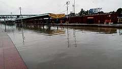
The 2008 Kosi flood was one of the most disastrous floods in the history of North Bihar, an impoverished and densely populated region in India. A breach in the Kosi embankment near the Indo-Nepal border (at Kusha in Nepal) occurred on 18 August 2008. The river changed course and inundated areas which hadn't experienced floods in many decades.[22] The flood affected over 2.3 million people in North Bihar.[23]
The flood killed 250 people and forced nearly 3 million people from their homes in North Bihar.[24] More than 300,000 houses were destroyed and at least 340,000 hectares (840,000 acres) of crops were damaged.[24] Villagers in North Bihar ate raw rice and flour mixed with polluted water. Hunger and disease were widespread. The Supaul district was the worst-hit; surging waters swamped 1,000 square kilometres (247,000 acres) of farmlands, destroying crops.[25]
 The Kosi before it flooded in August 2008
 The Kosi during the August 2008 flood
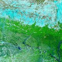
 Satellite image of flood waters in Bihar as of 31 August 2008; Image:UNOSAT
2017 North Bihar Floods
 | |
| Date | August 2017 |
|---|---|
| Location | North Bihar, India |
| Deaths | 514 |
2017 Floods affected 19 districts of North Bihar causing death of 514 people.[26][27][28][29][30] This flood was result of sudden increase in water discharge through rivers- Gandak, Burhi Gandak and Bagmati, Kamla, Kosi and Mahananda- due to heavy rain in the catchment areas of the major rivers of north Bihar in Nepal.[31] Araria district accounted for 95 deaths alone,[32] followed by Sitamarhi (34), West Champaran (29), Katihar (26), East Champaran (19) while 22 have died in Madhubani, Supaul(13) and Madhepura(15). 11 deaths were reported in Kishanganj, while Darbhanga accounted for 19 deaths, Purnea (9), Gopalganj (9), Sheohar(4), Muzaffarpur(7), Samastipur(1) and Saharsa(4) registered four deaths each while Khagaria and Saran accounted for 7 deaths each. Around 1.71 crore people are hit by the floods.[33][34][35][36]
See also
References
- ↑ "About North Bihar". North Bihar. Archived from the original on 12 October 2012. Retrieved 10 October 2012.
- ↑ "Naugachia". Archived from the original on 12 October 2012. Retrieved 10 October 2012.
- ↑ TOI. "Katihar Jute". The Times Of India. Archived from the original on 31 December 2017. Retrieved 31 December 2017.
- ↑ "About Kishanganj". STel. Archived from the original on 31 December 2017. Retrieved 31 December 2017.
- ↑ Shoumojit Banerjee (9 February 2012). "Mithilanchal gets back its lifeline". The Hindu. Chennai, India. Archived from the original on 10 May 2018. Retrieved 31 December 2017.
- ↑ "Rivers near Khagaria". Archived from the original on 31 December 2017. Retrieved 31 December 2017.
- ↑ "Khagaria". Wikimapia. Archived from the original on 31 December 2017. Retrieved 31 December 2017.
- ↑ East Central Railway (PDF). Indian Railway. p. 2. Archived (PDF) from the original on 29 May 2012.
- ↑ "BJP MP poser to Nitish". Times of India. 29 November 2011. Retrieved 31 December 2017.
- ↑ AAHSKK: ALPSANKHYAK AVAM HARIJAN SAMAJ KALYAN KENDRA. "An AGO in Muzaffarpur". Archived from the original on 14 August 2014. Retrieved 21 September 2012.
- ↑ District - Muzaffarpur (PDF). Patna, India: Road constructor Department, Government of Bihar. p. 1. Archived (PDF) from the original on 4 March 2016.
- ↑ "Sitamarhi district". Sitamarhi Temple. Archived from the original on 23 June 2012. Retrieved 10 October 2012.
- ↑ "Sheohar district". Bihar News Information Portal. Archived from the original on 31 December 2017. Retrieved 31 December 2017.
- ↑ "Central University at Motihari in Bihar, says govt". The Times of India. PTI. 18 August 2012. Retrieved 31 December 2017.
- ↑ "West Champaran". Brand Bihar. Archived from the original on 10 September 2013. Retrieved 31 December 2017.
- ↑ "Bihari Languages". You Bihar. Archived from the original on 12 October 2012. Retrieved 11 October 2012.
- ↑ "Languages of Bihar". Tour Travel World. Archived from the original on 15 October 2012. Retrieved 11 October 2012.
- ↑ Braja Bihārī Kumāra. Small States Syndrome in India. Concept Publishing Company. p. 146. Archived from the original on 31 December 2017.
- ↑ "Bihar's scary new flood".
- ↑ "Rivers of Bihar | Bihar Articles". Bihar.ws. Archived from the original on 23 July 2012. Retrieved 4 May 2012.
- ↑ A report by the Department of disaster management, Government of Bihar
- ↑ "A Dalit watch report on the flood camps in Bihar". India Water Portal. 22 June 2011. Archived from the original on 31 December 2017. Retrieved 31 December 2017.
- ↑ "Half of Bihar under water, 30 lakh suffer". CNN IBN. 1 September 2008. Archived from the original on 3 September 2008. Retrieved 31 December 2017.
- 1 2 Michael Coggan in New Delhi (29 August 2008). "Death toll rises from Indian floods - Just In (Australian Broadcasting Corporation)". ABC. Archived from the original on 5 November 2017. Retrieved 31 December 2017.
- ↑ Sunil Kataria (29 August 2008). "Bihar villagers desperate as floods spread". Reuters. Archived from the original on 31 December 2017. Retrieved 31 December 2017.
- ↑ Abhay Singh (29 August 2017). "Floods in state not man-made, says minister". Times of India. TNN. Archived from the original on 31 December 2017. Retrieved 31 December 2017.
- ↑ "Flood Situation Improves In Bihar, Number Of Dead At 514". NDTV. 28 August 2017. Archived from the original on 31 December 2017. Retrieved 31 December 2017.
- ↑ "Flood situation worsens in Bihar, death toll rises to 253". Times of India. PTI. 20 August 2017. Archived from the original on 31 December 2017. Retrieved 31 December 2017.
- ↑ "Bihar floods: 119 dead; bridge collapse caught on camera". Times of India. 18 August 2017. Archived from the original on 27 October 2017. Retrieved 31 December 2017.
- ↑ "Bihar floods: Death toll rises to 202 in 18 districts; thundershowers likely to continue today". 20 August 2017. Archived from the original on 25 August 2017. Retrieved 31 December 2017.
- ↑ "Alert sounded in north Bihar plains". Times of India. TNN. 12 August 2017. Archived from the original on 31 December 2017. Retrieved 31 December 2017.
- ↑ "Death toll in Bihar floods mounts to 304; situation grim in UP". Times of India. PTI. 21 August 2017. Archived from the original on 31 December 2017. Retrieved 31 December 2017.
- ↑ "Bihar Flood Deaths Rise To 440; Prime Minister Announces Rs. 500 Crore Relief". NDTV. 27 August 2017. Archived from the original on 19 September 2017. Retrieved 31 December 2017.
- ↑ "Bihar floods' death toll touches 440, 1.71 crore people still affected". Archived from the original on 27 August 2017.
- ↑ "Bihar floods cost 39 more lives, UP staggers". Archived from the original on 10 May 2018.
- ↑ "Bihar floods: Death toll rises to 304, 1.38 crore people still battling deluge in 18 districts". The Hindu Business Line. PTI. Archived from the original on 28 August 2017. Retrieved 31 December 2017.