Darlington, South Australia
| Darlington Adelaide, South Australia | |||||||||||||||
|---|---|---|---|---|---|---|---|---|---|---|---|---|---|---|---|
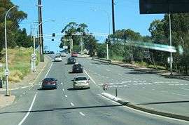 Flagstaff Hill Road, Darlington | |||||||||||||||
| Population | 1,081 (2006 census)[1] | ||||||||||||||
| Postcode(s) | 5047 | ||||||||||||||
| Location | 14 km (9 mi) south of Adelaide city centre | ||||||||||||||
| LGA(s) | |||||||||||||||
| Region | Southern Adelaide[2] | ||||||||||||||
| County | Adelaide[3] | ||||||||||||||
| State electorate(s) | Black | ||||||||||||||
| Federal Division(s) | Boothby | ||||||||||||||
| |||||||||||||||
Darlington is a suburb of Adelaide, South Australia part of which is in the City of Onkaparinga and the City of Marion. For many years, Darlington was the southern entrance to Adelaide's urban area on Main South Road. It hosted many service stations of different brands. It represents the convergence of Flagstaff Road to Main South Road from the south, with Seacombe Road to the west, Diagonal Road to the northwest and Marion Road to the north with South Road continuing northeast.
In about 1851 the village of Darlington was created and named by Samuel William Lewis, the licensed victualler of the Flagstaff Inn,[4] after the market town in County Durham in North East England named Darlington.[5] Lewis was the licensed victualler of the Flagstaff Inn during these years 1848-1853 - 1858 - 1860-1864.
Lewis was a stone mason by trade and he was contracted to erect the first two public memorials in the colony. The first was a memorial to Colonel William Light erected in 1843[5] over the site of his grave in Light Square.[6] The second was the monument to Matthew Flinders at Stamford Hill near Port Lincoln in 1844.
See also
References
- ↑ Australian Bureau of Statistics (25 October 2007). "Darlington (State Suburb)". 2006 Census QuickStats. Retrieved 28 March 2011.
- ↑ "Southern Adelaide SA Government region" (PDF). The Government of South Australia. Retrieved 17 April 2017.
- ↑ "Search result for "County of Adelaide, CNTY" with the following data sets selected - "Counties" and "Local Government Areas"". Property Location SA Map Viewer. Government of South Australia. Retrieved 24 April 2017.
- ↑ Bowden, Tom (9 October 2013). "The A-Z story of the history behind Adelaide's suburbs". The Advertiser. Retrieved 27 July 2016.
- 1 2 "Darlington". Property Location Browser. Government of South Australia. 7 January 2010. SA0017954. Retrieved 27 July 2016.
- ↑ "Adelaide Park Lands and Squares: Light Square Report" (PDF). Adelaide City Council. Adelaide City Council. 29 October 2007. Retrieved 27 July 2016.
Coordinates: 35°01′48″S 138°33′25″E / 35.030°S 138.557°E