Papineau-Cameron
| Papineau-Cameron | |
|---|---|
| Township (single-tier) | |
|
Township of Papineau-Cameron Canton de Papineau-Cameron | |
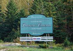 | |
 Papineau-Cameron | |
| Coordinates: 46°18′N 78°44′W / 46.300°N 78.733°WCoordinates: 46°18′N 78°44′W / 46.300°N 78.733°W | |
| Country |
|
| Province |
|
| District | Nipissing |
| Government | |
| • Type | Township |
| • Mayor | Robert Corriveau |
| Area | |
| • Land | 566.39 km2 (218.68 sq mi) |
| Population (2016)[1] | |
| • Total | 1,016 |
| • Density | 1.8/km2 (5/sq mi) |
| Time zone | UTC-5 (EST) |
| • Summer (DST) | UTC-4 (EDT) |
| Postal code | P0H 1V0 |
| Area code(s) | 705 |
| Website | www.papineaucameron.ca |
Papineau-Cameron is a municipal township in northeastern Ontario, Canada, in Nipissing District. The township is located on the south side of the Mattawa and Ottawa Rivers along Highway 17.
In 2007, Papineau-Cameron, along with the town of Mattawa and the townships of Bonfield, Mattawan and Calvin cooperated to create a newly branded Mattawa Voyageur Country tourist region in order to promote the area.[2]
Communities
The township includes the communities of Klock, Morel, and Rankin.
Demographics
According to the Canada 2011 Census:[3]
- Population: 978
- Change (2001-2006): -7.6 %
- Dwellings: 439
- Area (km²): 566.74
- Density (persons per km²): 1.7
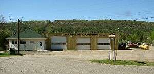
Municipal building of Papineau-Cameron
See also
References
- ↑ "2011 Census Profile".
- ↑ Adams, K. "Mattawa sports a new look", Baytoday.ca, July 17, 2007. Accessed March 28, 2008.
- ↑ "2011 Census Profile".
Places adjacent to Papineau-Cameron | |
|---|---|
| Cities | 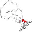 | |
|---|---|---|
| Towns | ||
| Townships | ||
| First Nations | ||
| Indian reserves | ||
| Unorganized areas | ||
| Local services boards | ||
| ||
This article is issued from
Wikipedia.
The text is licensed under Creative Commons - Attribution - Sharealike.
Additional terms may apply for the media files.