Lake Tahoe – Nevada State Park
| Lake Tahoe Nevada State Park | |
| Nevada State Park | |
 Cave Rock | |
| Country | |
|---|---|
| State | |
| Counties | Washoe, Douglas |
| City and village | Carson City, Incline Village |
| Elevation | 7,874 ft (2,400 m) [1] |
| Coordinates | 39°10′17″N 119°53′33″W / 39.17139°N 119.89250°WCoordinates: 39°10′17″N 119°53′33″W / 39.17139°N 119.89250°W [1] |
| Area | 14,301 acres (5,787 ha) |
| Established | 1958 (Sand Harbor) |
| - Established | 1967 (Cave Rock) |
| - Established | 1969 (Spooner Lake) |
| Management | Nevada Division of State Parks |
 Location in Nevada | |
| Website: Sand Harbor: Lake Tahoe Nevada State Park | |
Lake Tahoe–Nevada State Park is a state park comprising multiple management units and public recreation areas on the northeast shores of Lake Tahoe in the state of Nevada. The park covers approximately 14,301 acres (5,787 ha).[2] The Marlette Lake Water System, which is listed on the National Register of Historic Places and as a Historic Civil Engineering Landmark, lies within park boundaries.
Park units
- Sand Harbor
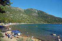
Sand Harbor features a large sandy beach, picnicking facilities, nature trail, boat launch, and visitors center and is the site of the Lake Tahoe Shakespeare Festival.[3] The Sand Harbor unit covers 55 acres (22 ha).[4]
- Cave Rock
Cave Rock is a day-use area along U.S. 50 with boat launch, picnic areas, and sandy beach. The site, located beneath Cave Rock and the Cave Rock Tunnel,[5] measures slightly more than three acres (1.2 ha).[6].
- Spooner Lake
Spooner Lake is located near the intersection of U.S. Route 50 and State Route 28 at "Spooner Summit." The unit's 1,140 acres (460 ha) are used for hiking, picnicking, fishing, and wildlife viewing. The site is the primary starting point for the Marlette/Hobart Backcountry trails and the main vehicle entrance to both areas. Snow Valley Peak may be reached by hiking along North Canyon Creek from Spooner Lake north almost to Marlett Lake and then east to the summit.[7]

- Marlette/Hobart Backcountry
The Marlette/Hobart Backcountry covers 12,183 acres (4,930 ha)[2] in the Carson Range.[8] Among the area's multiple trails are the Flume Trail, which has views of Lake Tahoe, and a portion of the Tahoe Rim Trail. The area encompasses Marlette Lake and Hobart Reservoir, which were created to feed the Marlette Lake Water System during the area's early mining and logging years. Remnants of abandoned mills can be seen. Two rustic cabins and several backpacking campsites provide overnight amenities.[7]
- Highway 28 Corridor
The park areas along Nevada State Route 28 cover 40 acres (16 ha) that include Hidden Beach, a secluded sandy beach just south of Incline Village accessible by trail or water, and Memorial Point, a roadside park that connects by trail to Sand Harbor.[2][3]
References
- 1 2 "Lake Tahoe State Park". Geographic Names Information System. United States Geological Survey.
- 1 2 3 "Lake Tahoe Nevada State Park Resource Management Plan" (PDF). Nevada Division of State Parks. July 2010. Archived from the original (PDF) on January 10, 2011. Retrieved April 1, 2011.
- 1 2 "Sand Harbor". Nevada State Parks. Department of Conservation and Natural Resources. Retrieved December 21, 2016.
- ↑ "Sand Harbor: Lake Tahoe Nevada State Park Brochure" (PDF). Nevada Division of State Parks. September 2011. Archived from the original (PDF) on June 12, 2015. Retrieved December 21, 2016.
- ↑ "Cave Rock". Nevada State Parks. Department of Conservation and Natural Resources. Retrieved January 30, 2018.
- ↑ "Inventory of State Lands" (PDF). Nevada Division of State Lands. May 2016. Retrieved January 30, 2018.
- 1 2 "Spooner Lake & Backcountry". Nevada State Parks. Department of Conservation and Natural Resources. Retrieved January 30, 2018.
- ↑ "Chapter 5: Inventory" (PDF). Nevada 2005 State Recreational Trails Plan. Nevada Division of State Parks, Planning and Development Section. pp. 79–84. Archived from the original (PDF) on December 21, 2016. Retrieved December 21, 2016.
External links
| Wikimedia Commons has media related to Lake Tahoe–Nevada State Park. |
- Sand Harbor—Lake Tahoe Nevada State Park Nevada State Parks
- Spooner Lake & Backcountry—Lake Tahoe Nevada State Park Nevada State Parks
- Cave Rock—Lake Tahoe Nevada State Park Nevada State Parks