Golconda, Nevada
| Golconda, Nevada | |
|---|---|
| Census-designated place | |
 | |
 Golconda Location within the state of Nevada | |
| Coordinates: 40°57′12″N 117°29′21″W / 40.95333°N 117.48917°WCoordinates: 40°57′12″N 117°29′21″W / 40.95333°N 117.48917°W | |
| Country | United States |
| State | Nevada |
| County | Humboldt |
| Area | |
| • Total | 9.0 sq mi (23.4 km2) |
| • Land | 9.0 sq mi (23.4 km2) |
| • Water | 0 sq mi (0 km2) |
| Population (2010) | |
| • Total | 214 |
| • Density | 24/sq mi (9.1/km2) |
| Time zone | UTC-8 (Pacific (PST)) |
| • Summer (DST) | UTC-7 (PDT) |
| FIPS code | 32-28500 |
| Reference no. | 105 |
Golconda is a census-designated place in southeastern Humboldt County, Nevada, United States. As of the 2010 census it had a population of 214.[1] It is located along Interstate 80 on the Humboldt River in the northwestern part of the state. Although it is unincorporated, Goldonda has a post office, which has been in operation since 1869.[2]
History
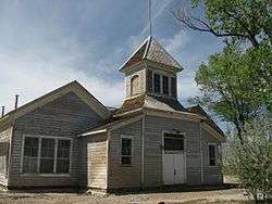
Golconda was founded in 1869.[3] The community was named for the ancient diamond mining center of Golkonda in India.[4] The settlement had its start when discovery of copper, silver, gold, and lead brought entrepreneurs who opened mines and mills in the district. The town was a diverse society including both native-born European Americans as well as other groups including individuals of French, Portuguese, Paiute, and Chinese descent who all lived and worked in the small community. During 1898-1910, the town had a train depot, several hotels, a school, businesses, newspapers, and two brothels. Its population peaked at about six hundred in 1907-08. Although boosters predicted growth for Golconda, after 1910 the mines played out, leaving the region as an area of ranches and farms. Most of the town's buildings from its mining heyday are gone, and Golconda today is a minor stop on Interstate 80.[5]
Geography
The community lies at an elevation of approximately 4,350 feet (1,330 m) 12 mi (19 km) east of Winnemucca across the Sonoma Range and 5.7 mi (9.2 km) west of Golconda Summit, a nearby mountain pass on Edna Mountain.[6] The Osgood Mountains lie across the Humboldt River to the north.
According to the United States Census Bureau, the Golconda CDP has an area of 9.0 square miles (23.4 km2), all land.[1]
References
- 1 2 "Geographic Identifiers: 2010 Demographic Profile Data (G001): Golconda CDP, Nevada". U.S. Census Bureau, American Factfinder. Retrieved January 24, 2013.
- ↑ U.S. Geological Survey Geographic Names Information System: Golconda Post Office
- ↑ Federal Writers' Project (1941). Origin of Place Names: Nevada (PDF). W.P.A. p. 37.
- ↑ Gannett, Henry (1905). The Origin of Certain Place Names in the United States. Govt. Print. Off. p. 139.
- ↑ John M. Gomes, "Golconda's Glory Days, 1898-1910," Nevada Historical Society Quarterly, June 2007, Vol. 50#2 pp 145-167
- ↑ USGS Winnemucca, Nevada, 30 x 60 minute quadrangle, US Geological Survey 1986
Municipalities and communities of Humboldt County, Nevada, United States | ||
|---|---|---|
| City | 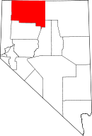 | |
| CDPs | ||
| Unincorporated communities | ||
| Ghost towns | ||
| Indian Reservations | ||
| Footnotes | ‡This populated place also has portions in an adjacent county or counties | |