Mottsville, Nevada
| Mottsville, Nevada | |
|---|---|
| Unincorporated community | |
_just_to_the_north.jpg) Mottsville, viewed from SR 207 | |
 Mottsville | |
| Coordinates: 38°55′43″N 119°50′16″W / 38.92861°N 119.83778°WCoordinates: 38°55′43″N 119°50′16″W / 38.92861°N 119.83778°W | |
| Country | United States |
| State | Nevada |
| County | Douglas |
| Elevation | 4,777 ft (1,456 m) |
| Time zone | UTC-8 (Pacific (PST)) |
| • Summer (DST) | UTC-7 (PDT) |
| Area code(s) | 775 |
| Nevada Historical Marker | 121[1] |
Mottsville is an unincorporated community in Douglas County, Nevada, United States. Mottsville is located at the junction of Nevada State Route 206 and Nevada State Route 207 4 miles (6.4 km) west-southwest of Minden.
History - Settlement on the Emigrant Trail where Hiram Mott and son Israel settled in 1851
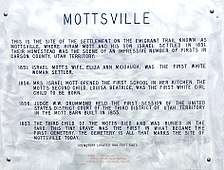 Mottsville, Nevada historical marker that commemorates early Nevada history
References
- ↑ "Nevada Historical Markers". Nevada State Historic Preservation Office. Archived from the original on 4 February 2013. Retrieved 24 February 2013.
Municipalities and communities of Douglas County, Nevada, United States | ||
|---|---|---|
| CDPs | 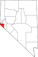 | |
| Unincorporated communities | ||
This article is issued from
Wikipedia.
The text is licensed under Creative Commons - Attribution - Sharealike.
Additional terms may apply for the media files.