| [3] |
Name on the Register[4] |
Image |
Date listed[5] |
Location |
City or town |
Description |
|---|
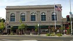
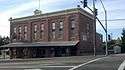
| 1 |
Auburn City Hall and Fire House |
|
December 19, 2011
(#11000935) |
1103 High St.
38°53′54″N 121°04′13″W / 38.898228°N 121.070367°W / 38.898228; -121.070367 (Auburn City Hall and Fire House) |
Auburn |
|
| 2 |
Auburn Fire House No. 1 |
|
December 19, 2011
(#11000936) |
El Dorado St. & Lincoln Way
38°54′14″N 121°03′59″W / 38.903808°N 121.066458°W / 38.903808; -121.066458 (Auburn Fire House No. 1) |
Auburn |
|
| 3 |
Auburn Fire House No. 2 |
|
December 19, 2011
(#11000937) |
Corner of Washington, Main, & Commercial Sts.
38°53′45″N 121°04′50″W / 38.895947°N 121.080442°W / 38.895947; -121.080442 (Auburn Fire House No. 2) |
Auburn |
|
| 4 |
Auburn Grammar School |
|
March 2, 2012
(#11000938) |
1225 Lincoln Way
38°53′52″N 121°04′30″W / 38.897897°N 121.074897°W / 38.897897; -121.074897 (Auburn Grammar School) |
Auburn |
|
| 5 |
Auburn Masonic Temple |
|
December 19, 2011
(#11000939) |
948 Lincoln Way
38°53′56″N 121°04′15″W / 38.898953°N 121.070856°W / 38.898953; -121.070856 (Auburn Masonic Temple) |
Auburn |
|
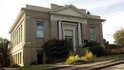
| 6 |
Auburn Public Library |
|
March 31, 2011
(#11000153) |
175 Almond St.
38°53′59″N 121°04′19″W / 38.899722°N 121.071944°W / 38.899722; -121.071944 (Auburn Public Library) |
Auburn |
|
| 7 |
Irene Burns House |
|
April 9, 2013
(#13000141) |
405 Linden Ave.
38°53′55″N 121°04′00″W / 38.898548°N 121.066761°W / 38.898548; -121.066761 (Irene Burns House) |
Auburn |
|
| 8 |
California Granite Company |
|
July 3, 2012
(#12000375) |
5255 Pacific St.
38°47′21″N 121°14′08″W / 38.789207°N 121.235602°W / 38.789207; -121.235602 (California Granite Company) |
Rocklin |
|
| 9 |
Carnegie Library |
|
April 10, 2009
(#09000199) |
557 Lincoln St.
38°45′13″N 121°17′07″W / 38.753722°N 121.285278°W / 38.753722; -121.285278 (Carnegie Library) |
Roseville |
|
| 10 |
Chapel of the Transfiguration |
|
August 18, 2011
(#11000534) |
855 W. Lake Blvd.
39°09′12″N 120°08′50″W / 39.153333°N 120.147222°W / 39.153333; -120.147222 (Chapel of the Transfiguration) |
Tahoe City |
|
| 11 |
Colfax Freight Depot |
|
December 17, 1999
(#99001564) |
7 Main St.
39°06′04″N 120°57′11″W / 39.101029°N 120.953009°W / 39.101029; -120.953009 (Colfax Freight Depot) |
Colfax |
|
| 12 |
Colfax Passenger Depot |
|
January 15, 1999
(#98001605) |
Main St. and Railroad Ave.
39°05′58″N 120°57′08″W / 39.099444°N 120.952222°W / 39.099444; -120.952222 (Colfax Passenger Depot) |
Colfax |
|
| 13 |
Earl Crabbe Gymnasium |
|
July 31, 2017
(#100001384) |
Agard St.
38°53′42″N 121°04′13″W / 38.895043°N 121.070333°W / 38.895043; -121.070333 (Earl Crabbe Gymnasium) |
Auburn |
|
| 14 |
DeWitt General Hospital |
|
February 12, 2016
(#16000003) |
1st St. & Bell Ave.
38°56′31″N 121°06′14″W / 38.941890°N 121.103830°W / 38.941890; -121.103830 (DeWitt General Hospital) |
Auburn |
|
| 15 |
Dutch Flat Historic District |
|
March 28, 1973
(#73000419) |
Main and Stockton Sts.
39°12′17″N 120°50′05″W / 39.204722°N 120.834722°W / 39.204722; -120.834722 (Dutch Flat Historic District) |
Dutch Flat |
|
| 16 |
El Toyon |
|
March 31, 2010
(#10000118) |
211 Brook Rd.
38°53′46″N 121°03′41″W / 38.895975°N 121.061461°W / 38.895975; -121.061461 (El Toyon) |
Auburn |
|
| 17 |
Fiddyment Ranch Main Complex |
|
July 26, 2010
(#10000503) |
4440 Phillip Rd.
38°47′07″N 121°22′38″W / 38.785278°N 121.377222°W / 38.785278; -121.377222 (Fiddyment Ranch Main Complex) |
Roseville |
|
| 18 |
Griffith House |
|
December 19, 1978
(#78000733) |
7325 English Colony Way
38°51′08″N 121°09′55″W / 38.852222°N 121.165278°W / 38.852222; -121.165278 (Griffith House) |
Penryn |
|
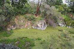
| 19 |
Griffith Quarry |
|
October 20, 1977
(#77000322) |
Taylor Rd.
38°50′58″N 121°09′44″W / 38.849444°N 121.162222°W / 38.849444; -121.162222 (Griffith Quarry) |
Penryn |
|
| 20 |
Haman House |
|
November 17, 1976
(#76000507) |
424 Oak St.
38°44′49″N 121°17′04″W / 38.746944°N 121.284444°W / 38.746944; -121.284444 (Haman House) |
Roseville |
|
| 21 |
Lake Tahoe Dam |
|
March 25, 1981
(#81000713) |
SR 89 at Truckee River
39°10′01″N 120°08′38″W / 39.166944°N 120.143889°W / 39.166944; -120.143889 (Lake Tahoe Dam) |
Tahoe City |
|
| 22 |
Lincoln Public Library |
|
December 10, 1990
(#90001814) |
590 Fifth St.
38°53′29″N 121°17′26″W / 38.891389°N 121.290556°W / 38.891389; -121.290556 (Lincoln Public Library) |
Lincoln |
|
| 23 |
Michigan Bluff-Last Chance Trail |
|
June 26, 1992
(#92000854) |
From Michigan Bluff NE to Last Chance
39°04′38″N 120°40′59″W / 39.077222°N 120.683056°W / 39.077222; -120.683056 (Michigan Bluff-Last Chance Trail) |
Michigan Bluff |
|
| 24 |
Mountain Quarries Bridge |
|
February 11, 2004
(#04000014) |
North Fork of the American River
38°54′46″N 121°02′30″W / 38.912792°N 121.041581°W / 38.912792; -121.041581 (Mountain Quarries Bridge) |
Auburn |
|
| 25 |
Newcastle Portuguese Hall |
|
March 25, 1982
(#82002225) |
Taylor Rd.
38°52′25″N 121°08′24″W / 38.873611°N 121.14°W / 38.873611; -121.14 (Newcastle Portuguese Hall) |
Newcastle |
|
| 26 |
Oddfellows Hall |
|
December 19, 2011
(#11000940) |
1256 Lincoln Way
38°53′52″N 121°04′30″W / 38.897847°N 121.074972°W / 38.897847; -121.074972 (Oddfellows Hall) |
Auburn |
Three-story red brick Italianate home of IOOF Lodge No. 7, founded in 1852. Henry T. Holmes, builder of the Hall, was a '49er and a founding father of Auburn.[6] |
| 27 |
Old Auburn Historic District |
|
December 29, 1970
(#70000138) |
Roughly bounded by Maple, Commercial, Court, Washington, Spring, and Sacramento Sts.
38°53′39″N 121°04′34″W / 38.894167°N 121.076111°W / 38.894167; -121.076111 (Old Auburn Historic District) |
Auburn |
|
| 28 |
Outlet Gates and Gatekeeper's Cabin |
|
December 13, 1972
(#72000245) |
U.S. 89 at mouth of Truckee River
39°10′00″N 120°08′33″W / 39.166667°N 120.1425°W / 39.166667; -120.1425 (Outlet Gates and Gatekeeper's Cabin) |
Tahoe City |
|
| 29 |
Placer County Bank |
|
December 19, 2011
(#11000941) |
874 Lincoln Way
38°54′01″N 121°04′09″W / 38.900356°N 121.069125°W / 38.900356; -121.069125 (Placer County Bank) |
Auburn |
|
| 30 |
Stevens Trail |
|
November 20, 2002
(#02001391) |
Roughly bounded Iowa Hill, canyon of North fork Of American R., until at Secret Ravine, top of ridge of Colfax
39°06′52″N 120°54′17″W / 39.114444°N 120.904722°W / 39.114444; -120.904722 (Stevens Trail) |
Colfax |
|
| 31 |
Strap Ravine Nisenan Maidu Indian Site |
|
January 8, 1973
(#73000420) |
1970 Johnson Ranch Dr.[7]
38°44′19″N 121°14′45″W / 38.7386°N 121.2458°W / 38.7386; -121.2458 (Strap Ravine Nisenan Maidu Indian Site) |
Roseville |
|
| 32 |
Summit Soda Springs |
|
December 15, 1978
(#78000734) |
Southeast of Soda Springs
39°14′48″N 120°19′30″W / 39.246667°N 120.325°W / 39.246667; -120.325 (Summit Soda Springs) |
Soda Springs |
|
| 33 |
Watson Log Cabin |
|
August 24, 1979
(#79000518) |
560 N. Lake Blvd
39°10′17″N 120°08′20″W / 39.171389°N 120.138889°W / 39.171389; -120.138889 (Watson Log Cabin) |
Tahoe City |
|
| 34 |
Woman's Club of Lincoln |
|
May 30, 2001
(#01000331) |
499 E St.
38°53′29″N 121°17′19″W / 38.891389°N 121.288611°W / 38.891389; -121.288611 (Woman's Club of Lincoln) |
Lincoln |
|


%2C_main_building.jpg)
%2C_facade.jpg)
.jpg)

_Public_Library.jpg)


_Portuguese_Hall%2C_facade.jpg)


%2C_entrance.jpg)