Whitney, California
| Whitney | |
|---|---|
| Unincorporated community | |
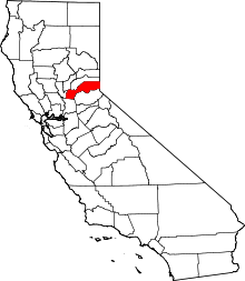
 Whitney Location in California  Whitney Whitney (the US) | |
| Coordinates: 38°50′01″N 121°18′25″W / 38.83361°N 121.30694°WCoordinates: 38°50′01″N 121°18′25″W / 38.83361°N 121.30694°W | |
| Country |
|
| State |
|
| County | Placer County |
| Elevation[1] | 131 ft (40 m) |
Whitney is an unincorporated community in Placer County, California.[1] Whitney is located on the Southern Pacific Railroad, 6 miles (9.7 km) north-northwest of Roseville.[2] It lies at an elevation of 131 feet (40 m).[1]
The name honors a local rancher, Joel Parker Whitney.[2]
Whitney's Pyramid Tomb is located in Rocklin, California at 38°49′33″N 121°14′48″W / 38.825928°N 121.246666°W and is accessible from Rocklin Monument Park from two approaches. The first if from the paved walking path of the park that begins in the cul-de-sac of Ketchikan Drive, and the second is from a footpath starting near the end of Hood Road and Sitka Drive in Rocklin, California.
References
This article is issued from
Wikipedia.
The text is licensed under Creative Commons - Attribution - Sharealike.
Additional terms may apply for the media files.