Clipper Gap, California
| Clipper Gap | |
|---|---|
| Unincorporated community | |
 Clipper Gap Location in California  Clipper Gap Clipper Gap (the US) | |
| Coordinates: 38°58′10″N 121°01′03″W / 38.96944°N 121.01750°WCoordinates: 38°58′10″N 121°01′03″W / 38.96944°N 121.01750°W | |
| Country |
|
| State |
|
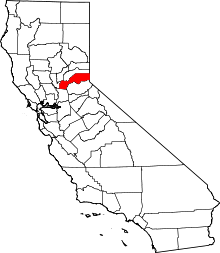
| County | Placer County |
| Elevation[1] | 1,676 ft (511 m) |
Clipper Gap (also, Clippergap)[2] is an unincorporated community in Placer County, California.[1] Clipper Gap is located 6 miles (9.7 km) north-northeast of Auburn.[2] It lies at an elevation of 1676 feet (511 m).[1]
The Clipper Gap post office opened in 1866, changed its name to Clippergap in 1894, reverted its name to Clipper Gap in 1950, and closed for good in 1960.[2]
References
This article is issued from
Wikipedia.
The text is licensed under Creative Commons - Attribution - Sharealike.
Additional terms may apply for the media files.