Foresthill, California
| Foresthill, California | |
|---|---|
| census-designated place | |
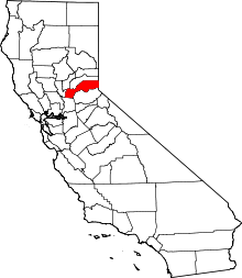
 Location in Placer County and the state of California | |
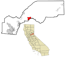
 Foresthill, California Location in the United States | |
| Coordinates: 39°1′10″N 120°50′10″W / 39.01944°N 120.83611°WCoordinates: 39°1′10″N 120°50′10″W / 39.01944°N 120.83611°W | |
| Country |
|
| State |
|
| County |
|
| Government | |
| • State Senate | Dave Cox (R) |
| • State Assembly | Ted Gaines (R) |
| • U. S. Congress | Tom McClintock (R)[1] |
| Area[2] | |
| • Total | 11.188 sq mi (28.977 km2) |
| • Land | 11.188 sq mi (28.977 km2) |
| • Water | 0 sq mi (0 km2) 0% |
| Elevation | 3,228 ft (984 m) |
| Population (2010) | |
| • Total | 1,483 |
| • Density | 130/sq mi (51/km2) |
| Time zone | UTC-8 (PST) |
| • Summer (DST) | UTC-7 (PDT) |
| ZIP code | 95631 |
| Area code(s) | 530 |
| FIPS code | 06-24834 |
| GNIS feature ID | 0277518 |
| Reference no. | 399 |
Foresthill is a census-designated place (CDP) in Placer County, California, United States. It is part of the Sacramento–Arden-Arcade–Roseville Metropolitan Statistical Area. The population was 1,483 at the 2010 census, down from 1,791 at the 2000 census.
History
Foresthill is located on a broad ridge between the North and Middle Forks of the American River on the gold-bearing gravel bed of an ancient river.
In the spring of 1850, miners came to the Forest Hill Divide in large numbers. There was one route from Auburn through Yankee Jim's and one from Coloma. At the junction of these trails, the Forest House hotel and trading post was built. The height of mining activity in Foresthill began in 1853 after a winter landslide at the head of Jenny Lind Canyon exposed numerous nuggets of gold. The Jenny Lind mine produced about $2,500 of gold a day for a while, up to a total output over $1 million by 1880. The combined production of all the mines in the Forest Hill area was estimated at $10 million by 1868[3] with gold selling for $16 an ounce.
In the 1860s, there were about 125,000 feet (38,000 m) of hard-rock tunnels dug into the hillsides in, around and under Foresthill. By 1857, this area had become an important center for trade among the many gold camps on the divide. In 1862, the Hardy-Kennedy building was erected - the first fireproof store in Foresthill. This building, now known as the Langstaff building, is still being used by the merchants of Foresthill.
By 1880, Foresthill was one of the largest towns in Placer County. The town had an 80-foot (24 m) wide main street befitting such an important place. Today the town has a marker identifying it as a California Historical Landmark.[3]
Geography
According to the United States Census Bureau Foresthill has a total area of 11.2 square miles (29 km2), all of it land.
Climate
Foresthill has a hot-summer Mediterranean climate that is characterized by cool, wet winters and hot, dry summers (Köppen climate classification Csa).
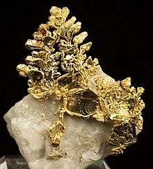
| Wikimedia Commons has media related to Eagles Nest Mine. |
| Climate data for Foresthill, California | |||||||||||||
|---|---|---|---|---|---|---|---|---|---|---|---|---|---|
| Month | Jan | Feb | Mar | Apr | May | Jun | Jul | Aug | Sep | Oct | Nov | Dec | Year |
| Record high °F (°C) | 77 (25) |
80 (27) |
85 (29) |
91 (33) |
102 (39) |
111 (44) |
113 (45) |
112 (44) |
106 (41) |
101 (38) |
87 (31) |
75 (24) |
113 (45) |
| Average high °F (°C) | 53 (12) |
60 (16) |
64 (18) |
70 (21) |
80 (27) |
89 (32) |
94 (34) |
92 (33) |
87 (31) |
77 (25) |
62 (17) |
53 (12) |
73 (23) |
| Daily mean °F (°C) | 46 (8) |
51 (11) |
54 (12) |
59 (15) |
67 (19) |
74 (23) |
79 (26) |
77 (25) |
73 (23) |
64 (18) |
53 (12) |
46 (8) |
62 (17) |
| Average low °F (°C) | 38 (3) |
42 (6) |
44 (7) |
47 (8) |
53 (12) |
60 (16) |
63 (17) |
62 (17) |
58 (14) |
51 (11) |
44 (7) |
39 (4) |
50 (10) |
| Record low °F (°C) | 22 (−6) |
21 (−6) |
26 (−3) |
34 (1) |
37 (3) |
46 (8) |
50 (10) |
49 (9) |
42 (6) |
35 (2) |
27 (−3) |
20 (−7) |
20 (−7) |
| Average precipitation inches (mm) | 4.10 (104.1) |
3.35 (85.1) |
3.21 (81.5) |
1.70 (43.2) |
0.50 (12.7) |
0.21 (5.3) |
0.07 (1.8) |
0.10 (2.5) |
0.46 (11.7) |
1.37 (34.8) |
3.93 (99.8) |
3.03 (77) |
22.03 (559.6) |
| Source: http://www.myforecast.com/bin/climate.m?city=11744&metric=false | |||||||||||||
Points of Interest
Demographics
| Historical population | |||
|---|---|---|---|
| Census | Pop. | %± | |
| U.S. Decennial Census[4] | |||
2010
The 2010 United States Census[5] reported that Foresthill had a population of 1,483. The population density was 132.6 people per square mile (51.2/km²). The racial makeup of Foresthill was 1,371 (92.4%) White, 8 (0.5%) African American, 29 (2.0%) Native American, 6 (0.4%) Asian, 2 (0.1%) Pacific Islander, 17 (1.1%) from other races, and 50 (3.4%) from two or more races. Hispanic or Latino of any race were 97 persons (6.5%).
The Census reported that 1,483 people (100% of the population) lived in households, 0 (0%) lived in non-institutionalized group quarters, and 0 (0%) were institutionalized.
There were 625 households, out of which 182 (29.1%) had children under the age of 18 living in them, 314 (50.2%) were opposite-sex married couples living together, 66 (10.6%) had a female householder with no husband present, 45 (7.2%) had a male householder with no wife present. There were 49 (7.8%) unmarried opposite-sex partnerships, and 9 (1.4%) same-sex married couples or partnerships. 140 households (22.4%) were made up of individuals and 53 (8.5%) had someone living alone who was 65 years of age or older. The average household size was 2.37. There were 425 families (68.0% of all households); the average family size was 2.76.
The population was spread out with 301 people (20.3%) under the age of 18, 118 people (8.0%) aged 18 to 24, 304 people (20.5%) aged 25 to 44, 540 people (36.4%) aged 45 to 64, and 220 people (14.8%) who were 65 years of age or older. The median age was 45.7 years. For every 100 females, there were 99.1 males. For every 100 females age 18 and over, there were 100.0 males.
There were 681 housing units at an average density of 60.9 per square mile (23.5/km²), of which 407 (65.1%) were owner-occupied, and 218 (34.9%) were occupied by renters. The homeowner vacancy rate was 1.4%; the rental vacancy rate was 6.0%. 965 people (65.1% of the population) lived in owner-occupied housing units and 518 people (34.9%) lived in rental housing units.
2000
As of the census[6] of 2000, there were 1,791 people, 673 households, and 465 families residing in the CDP. The population density was 159.9 people per square mile (61.7/km²). There were 717 housing units at an average density of 64.0 per square mile (24.7/km²). The racial makeup of the CDP was 90.34% White, 0.61% Black or African American, 2.68% Native American, 0.06% Asian, 0.45% Pacific Islander, 1.95% from other races, and 3.91% from two or more races. 5.75% of the population were Hispanic or Latino of any race.
There were 673 households out of which 38.2% had children under the age of 18 living with them, 49.6% were married couples living together, 12.9% had a female householder with no husband present, and 30.8% were non-families. 22.3% of all households were made up of individuals and 7.4% had someone living alone who was 65 years of age or older. The average household size was 2.66 and the average family size was 3.14.
In the CDP, the population was spread out with 30.2% under the age of 18, 6.4% from 18 to 24, 30.3% from 25 to 44, 23.1% from 45 to 64, and 10.1% who were 65 years of age or older. The median age was 36 years. For every 100 females, there were 105.6 males. For every 100 females age 18 and over, there were 102.8 males.
The median income for a household in the CDP was $34,348, and the median income for a family was $41,161. Males had a median income of $41,438 versus $25,813 for females. The per capita income for the CDP was $19,409. About 9.9% of families and 12.6% of the population were below the poverty line, including 17.2% of those under age 18 and 4.8% of those age 65 or over.
References
- ↑ "California's 4th Congressional District - Representatives & District Map". Civic Impulse, LLC. Retrieved March 3, 2013.
- ↑ U.S. Census Archived 2012-07-14 at WebCite
- 1 2 "Foresthill". Office of Historic Preservation, California State Parks. Retrieved 2012-10-11.
- ↑ "Census of Population and Housing". Census.gov. Retrieved June 4, 2016.
- ↑ "2010 Census Interactive Population Search: CA - Foresthill CDP". U.S. Census Bureau. Retrieved July 12, 2014.
- ↑ "American FactFinder". United States Census Bureau. Archived from the original on 2013-09-11. Retrieved 2008-01-31.