National Register of Historic Places listings in Millard County, Utah
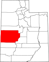
Location of Millard County in Utah
This is a list of the National Register of Historic Places listings in Millard County, Utah.
This is intended to be a complete list of the properties and districts on the National Register of Historic Places in Millard County, Utah, United States. Latitude and longitude coordinates are provided for many National Register properties and districts; these locations may be seen together in a map.[1]
There are 30 properties and districts listed on the National Register in the county, including 1 National Historic Landmark. One other site in the county was once listed, but has since been removed.
- This National Park Service list is complete through NPS recent listings posted October 11, 2018.[2]
Current listings
| [3] | Name on the Register[4] | Image | Date listed[5] | Location | City or town | Description |
|---|---|---|---|---|---|---|
| 1 | Archeological Site No. 42Md300 | August 6, 1980 (#80003911) |
Address Restricted[6] |
Delta | A depression near the Sevier River southwest of Delta, an archaeological site that has yielded hundreds of Paleoindian artifacts.[7] | |
| 2 | Thomas Clark and Millie Callister House | January 17, 2017 (#100000511) |
155 S. 100 East 38°57′54″N 112°19′15″W / 38.964990°N 112.320889°W |
Fillmore | ||
| 3 | Central Utah Relocation Center (Topaz) Site | 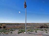 |
March 29, 2007 (#07000432) |
10500 W. 500 North 39°24′40″N 112°46′20″W / 39.411111°N 112.772222°W |
Delta | |
| 4 | Cottonwood Wash (42 MD 183) | June 4, 1985 (#85001233) |
Address Restricted[6] |
Milford | ||
| 5 | Cove Fort | 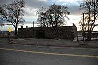 |
October 6, 1970 (#70000623) |
2 miles (3.2 km) east of Interstate 15 on State Route 161 38°36′06″N 112°34′49″W / 38.601667°N 112.580278°W |
Cove Fort | |
| 6 | Deseret (42 MD 55) | June 4, 1985 (#85001234) |
Address Restricted[6] |
Deseret | ||
| 7 | Deseret Relief Society Hall | 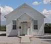 |
December 13, 1995 (#95001431) |
4365 S. 4000 West 39°17′21″N 112°39′09″W / 39.289107°N 112.652374°W |
Deseret | |
| 8 | Desert Experimental Range Station Historic District | April 11, 1994 (#94000267) |
2.5 miles (4.0 km) north of U.S. Route 21, 42 miles (68 km) west of Milford 38°36′01″N 113°44′44″W / 38.600278°N 113.745556°W |
Milford | ||
| 9 | Fillmore American Legion Hall | January 24, 2011 (#10001174) |
80 S. Main St. 38°58′02″N 112°19′26″W / 38.967222°N 112.323889°W |
Fillmore | ||
| 10 | Fillmore City Cemetery | May 9, 2012 (#12000270) |
325 E. 600 South 38°57′19″N 112°18′52″W / 38.955278°N 112.314444°W |
Fillmore | ||
| 11 | Fort Deseret | 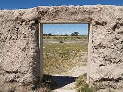 |
October 9, 1970 (#70000624) |
2 miles (3.2 km) south of Deseret on State Route 257 39°15′54″N 112°39′13″W / 39.265°N 112.653611°W |
Deseret | |
| 12 | George Hotel | 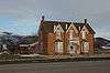 |
June 10, 2005 (#05000594) |
10 N. Main St. 38°48′06″N 112°26′13″W / 38.801667°N 112.436944°W |
Kanosh | |
| 13 | Gunnison Massacre Site | 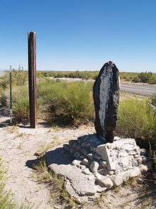 |
April 30, 1976 (#76001819) |
6 miles (9.7 km) southwest of Hinckley on the Sevier River 39°16′46″N 112°46′40″W / 39.279444°N 112.777778°W |
Hinckley | |
| 14 | Hinckley High School Gymnasium | 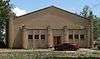 |
April 1, 1985 (#85000809) |
100 East south of 200 North 39°19′34″N 112°40′10″W / 39.326113°N 112.669347°W |
Hinckley | |
| 15 | Peter and Jessie Huntsman House | 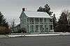 |
January 30, 1995 (#94001625) |
155 W. Center St. 38°58′08″N 112°19′38″W / 38.968889°N 112.327222°W |
Fillmore | |
| 16 | Kanosh Tithing Office | 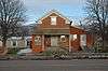 |
January 25, 1985 (#85000263) |
40 N. Main St. 38°48′08″N 112°26′11″W / 38.802222°N 112.436389°W |
Kanosh | |
| 17 | Meadow Tithing Granary | January 25, 1985 (#85000276) |
50 N. 100 West 38°53′12″N 112°24′42″W / 38.886667°N 112.411667°W |
Meadow | ||
| 18 | Millard Academy | _from_W_1.JPG) |
February 11, 1982 (#82004127) |
100 East and 200 North[8] 39°19′35″N 112°40′10″W / 39.326451°N 112.669385°W |
Hinckley | |
| 19 | Mountain Home Wash | June 4, 1985 (#85001235) |
Address Restricted[6] |
Milford | ||
| 20 | Edward and Elizabeth Partridge House | 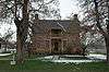 |
May 14, 1993 (#93000414) |
10 S. 200 West 38°58′07″N 112°19′44″W / 38.968611°N 112.328889°W |
Fillmore | |
| 21 | Pharo Village | October 10, 1975 (#75001813) |
Address Restricted[6] |
Scipio | ||
| 22 | The Princess Recreation Hall-Lynndyl LDS Meetinghouse | September 17, 2014 (#14000628) |
98 E. Center St. 39°31′08″N 112°22′26″W / 39.5190°N 112.374°W |
Lynndyl | ||
| 23 | Peter Quarnberg House | 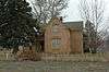 |
July 26, 1982 (#82004128) |
105 W. 100 South 39°14′36″N 112°06′20″W / 39.243333°N 112.105556°W |
Scipio | |
| 24 | Merien and Rosabelle Robins House | 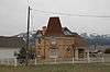 |
September 7, 2001 (#01000962) |
110 W. 200 North 39°14′55″N 112°06′20″W / 39.248611°N 112.105556°W |
Scipio | |
| 25 | Scipio Town Hall | 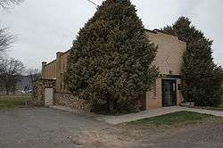 |
December 22, 1988 (#88002999) |
55 N. State St. 39°14′45″N 112°06′12″W / 39.245833°N 112.103333°W |
Scipio | |
| 26 | Site 42 MD 284 | June 4, 1985 (#85001236) |
Address Restricted[6] |
Fillmore | ||
| 27 | Thuesen-Petersen House | February 1, 1983 (#83004398) |
206 W. Center St. 39°14′43″N 112°06′30″W / 39.245278°N 112.108333°W |
Scipio | ||
| 28 | Topaz War Relocation Center Site | 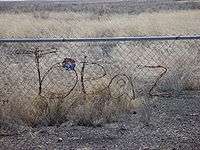 |
January 2, 1974 (#74001934) |
16 miles (26 km) northwest of Delta 39°24′49″N 112°46′28″W / 39.413611°N 112.774444°W |
Delta | |
| 29 | Utah Territorial Capitol | 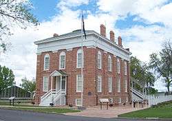 |
September 22, 1970 (#70000625) |
Center St. between Main and 100 West St. 38°58′04″N 112°19′28″W / 38.967778°N 112.324444°W |
Fillmore | |
| 30 | Van's Hall | January 27, 1995 (#94001629) |
321 W. Main St. 39°21′08″N 112°34′56″W / 39.352216°N 112.582183°W |
Delta |
Former listing
| [3] | Name on the Register | Image | Date listed | Date removed | Location | City or town | Summary |
|---|---|---|---|---|---|---|---|
| 1 | Millard High School Gymnasium | 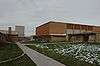 |
April 1, 1985 (#85000808) | September 3, 2009 | 35 N. 200 West 38°58′13″N 112°19′45″W / 38.9703°N 112.3292°W |
Fillmore |
See also
References
- ↑ The latitude and longitude information provided in this table was derived originally from the National Register Information System, which has been found to be fairly accurate for about 99% of listings. For about 1% of NRIS original coordinates, experience has shown that one or both coordinates are typos or otherwise extremely far off; some corrections may have been made. A more subtle problem causes many locations to be off by up to 150 yards, depending on location in the country: most NRIS coordinates were derived from tracing out latitude and longitudes from USGS topographical quadrant maps created under the North American Datum of 1927, which differs from the current, highly accurate WGS84 GPS system used by most on-line maps. Chicago is about right, but NRIS longitudes in Washington are higher by about 4.5 seconds, and are lower by about 2.0 seconds in Maine. Latitudes differ by about 1.0 second in Florida. Some locations in this table may have been corrected to current GPS standards.
- ↑ "National Register of Historic Places: Weekly List Actions". National Park Service, United States Department of the Interior. Retrieved on October 11, 2018.
- 1 2 Numbers represent an ordering by significant words. Various colorings, defined here, differentiate National Historic Landmarks and historic districts from other NRHP buildings, structures, sites or objects.
- ↑ National Park Service (2008-04-24). "National Register Information System". National Register of Historic Places. National Park Service.
- ↑ The eight-digit number below each date is the number assigned to each location in the National Register Information System database, which can be viewed by clicking the number.
- 1 2 3 4 5 6 Some listings on the NRHP are highly sensitive sites and may be subject to looting or vandalism. The NRHP lists this site as "Address Restricted."
- ↑ Simms, Steven R. (September 1987). Tipps, Betsy L., ed. "42MD300, A Paleoindian/Archaic Site near Delta, Utah" (PDF). The UPAC News. Utah Professional Archeological Council. 5 (3): 4. Retrieved February 9, 2010.
- ↑ See photo with street sign
External links

 |  | ||
| Topics | |
|---|---|
| Lists by states |
|
| Lists by insular areas | |
| Lists by associated states | |
| Other areas | |
| |
Municipalities and communities of Millard County, Utah, United States | ||
|---|---|---|
| Cities | | |
| Towns | ||
| CDPs | ||
| Unincorporated communities | ||
| Ghost towns | ||
| Indian reservation | ||
| Footnotes | ‡This populated place also has portions in an adjacent county or counties | |
This article is issued from
Wikipedia.
The text is licensed under Creative Commons - Attribution - Sharealike.
Additional terms may apply for the media files.